
Cady Ridge is a challenging and beautiful ridge walk with excellent views of Glacier Peak, tons of wildflowers early in the season and bushels of blueberries late in the season.
But the trail is more of access route than a hike in itself. If your time is limited, you can hike in about four miles to experience the ridge and views, but many will choose to hike further, either to Lake Sally Anne or as part of a weekend loop of Cady Ridge, Dishpan Gap and Meander Meadow.
Historically, Cady Ridge was used as a sheep trail, bringing livestock to high meadows for seasonal grazing, and the sheep apparently liked to go straight up hill. That's what you'll do too, on your way to gorgeous views.
From the Little Wenatchee trailhead, descend to the bridge across the Little Wenatchee River, then follow the trail downstream to a junction of the Cady Creek Trail and the Cady Ridge Trail.
Head up hill on the Cady Ridge trail. For the first mile, the trail climbs, following well laid out switchbacks, but these end as the trail rolls on to the ridge edge and the forgiving switchbacks give way to a straight-up-the-ridge route.
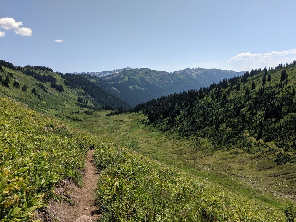
At 3.5 miles the grade eases, and views of Glacier Peak can be enjoyed. In season both berries and wildflowers abound. This is Cady Ridge proper, which is where you can stop if you're feeling breathless. If you'd like to continue onto Lake Sally Anne, stay on the trail and for the next few miles roll along the ridge the trail in a 50-foot wide clearing which appears to be the result of a fire break built long ago.
At 6.5 miles Cady Ridge intersects the Pacific Crest Trail (PCT). Turn south and in a half a mile you will come upon beautiful Lake Sally Anne.
WTA Pro Tip: Cady Ridge is one of three ways to access a beautiful backcountry loop! The Cady Ridge - Dishpan Gap - Meander Meadow Loop is 16 miles. It's gorgeous, but can be brushy as well as steep.
To avoid the brush of Meander Meadow, make a two or three night overnight trip, climb Cady Creek #1501, camp at Lake Sally Anne, Blue Lake or Meander Meadow. Visit Kodak Peak for incredible views of Glacier Peak, venture down Cady Ridge to see the wildflowers and excellent views on Cady Ridge Trail, and pick the return trail based on current conditions.
Cady Ridge

-
 Length
- 14.0 miles, roundtrip
-
 Elevation Gain
- 3,015 feet
-
 Highest Point
- 5,551 feet
When it comes to resplendent alpine meadows, the Henry M. Jackson Wilderness can't be beat. And when it comes to the finest flower romps within that wild area named for the longtime Washington senator and champion of conservation, Cady Ridge ranks supreme. A multitude of blossoms proliferate along this mile-high ridge. But it's the lupines that dominate, transforming Cady into a purple mountain majesty. And views! From the inspiring Poet Peaks, to the emerald-cloaked summits along the Cascade crest, to cloud-piercing, snow-catching, ice-harboring, horizon-dominating Glacier Peak!
Continue reading
Hiking Cady Ridge
Map & Directions
 Trailhead
Before You Go
Parking Pass/Entry Fee
Northwest Forest PassWTA Pro Tip: Save a copy of our directions before you leave! App-based driving directions aren't always accurate and data connections may be unreliable as you drive to the trailhead.
Getting There
Proceed to the junction of Highway 207 and Highway 2 at Coles Corner. This is 20 miles east of Stevens Pass, or 15 miles west of Leavenworth. Turn north on 207, and four miles later, just past the bridge over the Wenatchee River, bear left to remain on Highway 207.
Continue for 6.3 miles, then bear left on Little Wenatchee River Road. Continue 6.1 miles and bear right at junction on F6500. Continue 6.3 miles until the pavement ends, then continue for three miles on dirt road.
Note: Check trip reports for current condition of this section, as it can be rough. Park at the end of the road at the Little Wenatchee trailhead.


