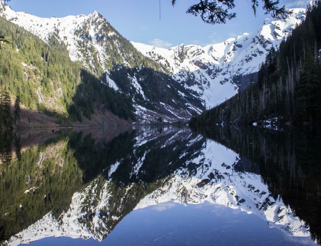

A nice hike with plenty of variety. Beautiful forest, a rushing creek, waterfalls of all shapes and sizes, history, and of course a large blue-green lake surrounded by snowy peaks. At 10.4 miles, it can be either a day-hike or a quick early season overnight. You won’t be alone, though – this is a popular trail with both hikers and backpackers.
The trail starts at the far end of the large parking lot. In just a few minutes, come to a well signed junction for the Upper Elliot and Lower Elliot trails. They’ll rejoin in approximately three miles, so the choice is yours. Consider taking one trail to the lake, and the other one on the trip back to your car.
The trail to the right drops down to the creek. You will be on a twisty trail surrounded by conifers, alders, ferns and skunk cabbage. The first mile or so is close enough to hear the creek and periodically enjoy peek-a-boo views of it. The tread is soft, and the stream crossings are small with stepping stones that may be partially submerged in the early season.
The trail to the left follows an old road. It is straight and wide, with a mild but constant uphill and then downhill grade. The trail consists of an old layer of packed gravel, and is lined with alders. Stream crossings are more difficult early season, but still manageable. There is an eroded culvert in one of the streams that is a little tricky to navigate, so take it slow and if you feel unsafe, don't go beyond your ability level.
If you opt for the upper trail views along the way will be of jagged peaks, two really nice waterfalls, small patches of wild strawberries, and lots of bleeding hearts. Be sure to avoid the Chokwich Creek Trail, which branches off to your left at 3.6 miles from the trailhead. On the trip back to the trailhead, you might not even notice this junction.
Shortly after the trails rejoin, the way gets a little rocky and the grade steepens. As you switchback up the hillside, keep your eyes and ears open for a large waterfall on your right. Continuing uphill, arrive at the root-ball of a large fallen tree. The trail switchbacks to the left here, but the adventurous will want to take a quick side trip to the right. There was once an old wood-planked road here and a bridge across the river to an old town site. The bridge is gone, but there is still a rushing waterfall worth visiting. You’ll have to contend with some fallen trees, but none of them are too bad.
After a bit more climbing, reach a well-signed junction just before the lake. The campsites and two open-air privies are to the left. There are at least 15 sites here, though none of them are particularly private. The forest is open and the camp resembles a terraced hillside.
The trail to the lake continues to the right. After a short distance, arrive at a signed day-use area. This is your best bet for a lunch overlooking the lake, or for letting your kids run around. Even though the trail is popular, there is some room to spread out here.
Goat Lake

-
 Length
- 10.4 miles, roundtrip
-
 Elevation Gain
- 1,400 feet
-
 Highest Point
- 3,161 feet
The Mountain Loop Highway is closed between Deer Creek and Bedal Campground for the winter season.
Parking Pass/Entry Fee
Northwest Forest Pass
A nice hike with plenty of variety. Beautiful forest, a rushing creek, waterfalls of all shapes and sizes, history, and of course a large blue-green lake surrounded by snowy peaks. At 10.4 miles, it can be either a day-hike or a quick early season overnight. You won’t be alone, though – this is a popular trail with both hikers and backpackers.
Continue reading
Hiking Goat Lake

WTA worked here in 2025, 2024, 2023, 2022 and 2021!
Map & Directions
 Trailhead
Before You Go
The Mountain Loop Highway is closed between Deer Creek and Bedal Campground for the winter season.
Parking Pass/Entry Fee
Northwest Forest PassWTA Pro Tip: Save a copy of our directions before you leave! App-based driving directions aren't always accurate and data connections may be unreliable as you drive to the trailhead.
Getting There
Take the Mountain Loop Highway east from Granite Falls. Pass by the Verlot Ranger Station, where you can buy a Northwest Forest Pass if you need one. Continue to the end of the pavement (about 31 miles from Granite Falls), and then go another 3.5 miles. Turn right at the road signed "Elliot and Goat Lakes." This is FR-4080, but the road number is not clearly marked. The parking lot is at the end of the good gravel road.


