

This route is located mostly in the Tronsen Meadows Non-motorized Area, which has marked ski trails and lots of options for cross-country snow travel. Since the route starts at a very popular snowmobile sno-park, the trip is better done mid-week, when the sound of snowmobiles does not intrude on the sereneness of winter.
This description follows the loop in a counterclockwise fashion, but of course, either direction is possible. Each way has its own advantages – counterclockwise uses a marked trail for all the climb, while clockwise features a half-mile ridgewalk facing Mount Rainier to the southwest.
From the Blewett Pass Sno-Park, on the south side of Highway 97 (elevation 4,100 feet), start on Road 9716 for 100 yards and go straight where the road turns left, climbing past the no snowmobiles sign. After a short, direct climb, reach the summer parking lot for the Swauk Forest Discovery Trail. A longer alternative is to follow the road up to the parking lot.
After crossing the parking lot, reach Forest Road 9716, turn right on the road and follow it for 0.25 mile to the start of Haney Meadows cross-country trail 15, on the left (elevation 4,340 feet). Follow the well-marked ski trail as it does a gradual climbing traverse through a mix of open area, forest, and burned forest from the 2012 Table Mountain Fire. At each of the trail junctions, stay on the Haney Meadows Trail. Note the junction with the Illiby Tie trail at 1.3 miles (elevation 4,550 feet). This is where the loop part of the route will close.
The trail now steepens as it traverses around to the partially burned narrow valley on the east side of Diamond Head. Along the way, it crosses a couple of open areas that skiers use for nice runs down to the trail, when the avalanche danger is low.
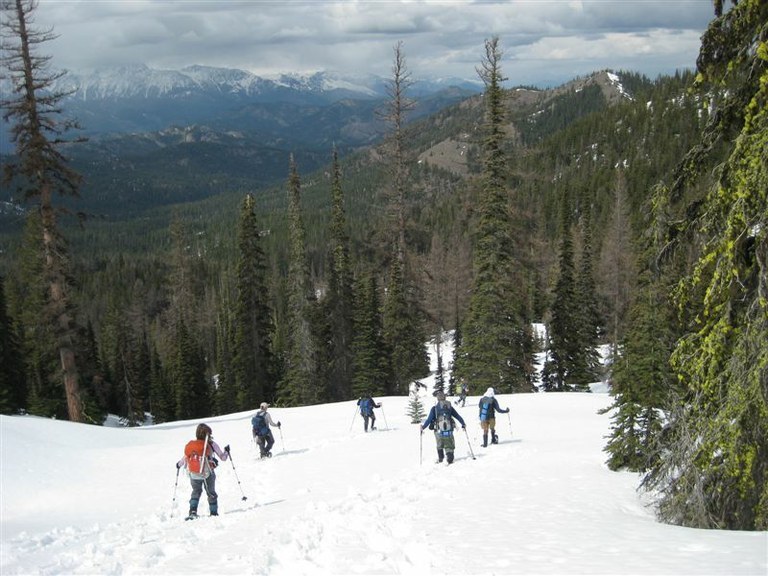
At 2.1 miles (elevation 5,260 feet), the ski trail turns east to cross the narrow gulley and climbs into the open as it climbs through an open bowl to a saddle on Windy Knob at 2.8 miles (elevation 5,730 feet). A short, steep, side route to the top of Windy Knob has good views, but better ones await up on View Ridge.
At the saddle, the trail turns to the southwest to climb through the burned forest up the toe of the ridge, before descending through a welcome pocket of surviving forest to a pass with summer trail junction signs. Shortly after the pass is a junction with the View Ridge Trail at 3.2 miles (elevation 5,730 feet).
The climb up the View Ridge Trail leads to an open ridge with dramatic views in all directions, Mount Rainier to the southwest, with Mount Stuart and the Stuart Range to the west. The high point at 3.5 miles (elevation 5,960) makes a great lunch stop on a clear day for a little R&R after the long climb.
After the high point, the trail is sparsely marked by tree trunks with partially melted aluminum disks that survived the fire. It is easiest to stay on or near the crest of the ridge on the south side.
Along the way, Haney Meadows is visible to the southeast, with a forest remnant around the summer campground. The south side of View Ridge is outside the non-motorized area and the road to the south of the ridge is a groomed snowmobile trail.
Enjoy the last views as the unmarked route continues along the ridge as it turns to the east northeast and descends through the forest to another pass at 4.3 miles (elevation 5,440 feet). From the pass, the objective is the east end of the lightly used Upper Tronsen Road Ski Trail located 0.5 mile to the northwest and about 500 feet lower.
Initially, go across the open area to its west-northwest edge and pass across the head of a secondary drainage. Continue northwesterly between an open area to the west and the main drainage about 100 yards to the east to reach the end of the ski trail at 4.9 miles (elevation 4,950 feet, at coordinates: 47.3200, -120.5405).
Follow the ski trail as it traverses westerly and descends through the partially burned forest, reaching the junction with the Illiby Tie Ski Trail at 6.2 miles (elevation 4,440 feet). Turn left onto the Illiby Tie Ski Trail, then climb up to its junction with the Haney Meadows Trail at 6.3 miles (elevation 4560 feet). Turn right onto the Haney Meadows Trail and backtrack the inbound route to reach the sno-park.
 Trailhead


