Trails for everyone, forever

Home Go Hiking Hiking Guide High Pass
link

High Pass

North Cascades > Mount Baker Area
48.9523, -121.6358 Map & Directions
Length
3.6 miles, roundtrip
Elevation Gain
765 feet
Highest Point
5,965 feet
Calculated Difficulty About Calculated Difficulty
Moderate
One the many great views seen along High Pass. Photo taken by TrailCat.
  • Wildflowers/Meadows
  • Mountain views
  • Wildlife
  • Fall foliage
  • Ridges/passes

Parking Pass/Entry Fee

Northwest Forest Pass

Discover views similar to Winchester Mountain and hike this seldom-traveled trail with views of Mount Larabee and increased chances of encountering wildlife. Continue reading

Rating
3.00 out of 5

(7 votes) Log in to rate

Hiking High Pass

Discover views similar to Winchester Mountain and hike this seldom-traveled trail with views of Mount Larabee and increased chances of encountering wildlife.

The trail to High Pass begins from the Twin Lakes Trailhead. You'll travel the first 0.2 miles uphill on the Winchester Mountain Trail — be on the lookout for the marker for the High Pass Trail fork that leads you off to to the right after the first switchback.

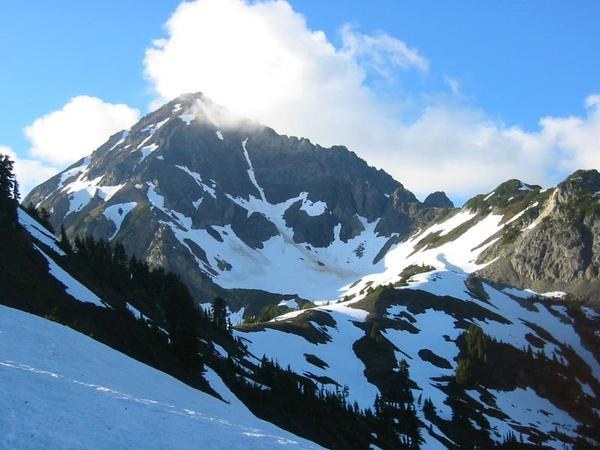
You'll continue to climb gently upward for a few hundred feet before coming to a crest that overlooks the Winchester Creek valley. Descend slightly while enjoying views of Mount Larabee and the Pleiades in the distance. Wildflowers grace the sloping hillside as you listen to the whistling of marmots in the valley below.

The trail clings to the valley's edge as you enter an avalanche chute on the northeast side of Winchester Mountain. At about a mile in you will encounter your first set of switchbacks. Tread carefully; the trail here is steep and narrow and one can easily lose their footing on the loose rocks.

Once past the switchbacks, you'll arrive at Low Pass. Enjoy views of Tomyhoi Peak and Yellow Aster Butte to the west. Walk a few hundred feet up a gentle incline to another set of short but steep switchbacks up a small butte, pausing to enjoy the peek-a-boo views of Mount Baker to the left.

At 1.5 miles in, you emerge on to a relatively flat ridge that will take you the final few hundred feet to High Pass in the shadow of Mount Larabee. You can choose to continue upwards on the trail to Larabee base camp or take the descending trail 0.3 miles to the Gargett Mine.

Hike Description Written by
Sara Thein, WTA Correspondent

High Pass

Map & Directions

Trailhead
Co-ordinates: 48.9523, -121.6358 Open in Google Maps

Before You Go

See weather forecast

Parking Pass/Entry Fee

Northwest Forest Pass

WTA Pro Tip: Save a copy of our directions before you leave! App-based driving directions aren't always accurate and data connections may be unreliable as you drive to the trailhead.

Getting There

From I-5, take exit 255 and drive State Route 542 33 miles to the Glacier Public Service Center (GPSC) just past the town of Glacier. From the GPSC, continue east on SR 542 12.5 miles. Immediately beyond the Department of Transportation’s Shuksan maintenance facility, veer left onto Twin Lakes Road. The road is narrow, rocky, and potholed, but driveable. At 4.5 miles, pass the Yellow Aster Butte trailhead, and the last reliable shoulder parking.

Beyond here, four-wheel drive is helpful, but a high clearance vehicle is essential. The rugged one-lane road passes a few camps and a vault toilet at the first lake (6.7 miles) then ends between the Twin Lakes, 7.0 miles from the turnoff onto Twin Lakes Road.

There are four camp sites, a vault toilet, and parking for about twenty vehicles, with overflow parking for several more.

More Hike Details

Trailhead

North Cascades > Mount Baker Area

High Pass (#676)

Mt. Baker-Snoqualmie National Forest, Mount Baker Ranger District

Guidebooks & Maps

Day Hiking: North Cascades (Romano - Mountaineers Books)

USGS: Mount Larrabee

USFS: Mt. Baker Ranger District and Mt. Baker Wilderness

Buy the Green Trails Mt. Shuksan No. 14 map

You can improve or add to this guidebook entry

High Pass

57 Trip Reports

Hiked here recently?

Submit a trip report!
 
Trip Reports