
A couple miles beyond Lake Stuart and a few hundred feet up lies Horseshoe Lake--a stunning, silent lake that makes for an excellent day trip for those lucky folks who get to camp at Lake Stuart. It’s also attainable as a day hike, but you’ll want to get an early start. Note that the round trip mileage given above is for a day hike from the Lake Stuart trailhead.
From Lake Stuart, follow the lakeshore trail back towards Mount Stuart pass several campsites before delving into denser forest. The rough path is relatively easy to follow, though the many downed trees that cross the trail can be frustrating, and when wet, slippery and dangerous. Take your time and watch your step here when it’s raining or if the wood is wet.
The trail winds in and out of the forest for two miles, dipping into a marshy meadow at the head of the valley before ultimately heading back into the forest. After about two miles of hiking, you'll make a righthand turn and start hiking uphill. It’s a no-nonsense route that climbs essentially straight up.
Watch your footing the entire way up, as the trail is rooty, rocky, and sometimes so straight up that it’s more like climbing a ladder than hiking uphill. Grus, or crumbled granite, can make for slippery conditions on trail, particularly where you’re hiking on larger granite slabs. The final push to the lake is nearly vertical; a thigh burner going up and one that calls for extra caution descending.
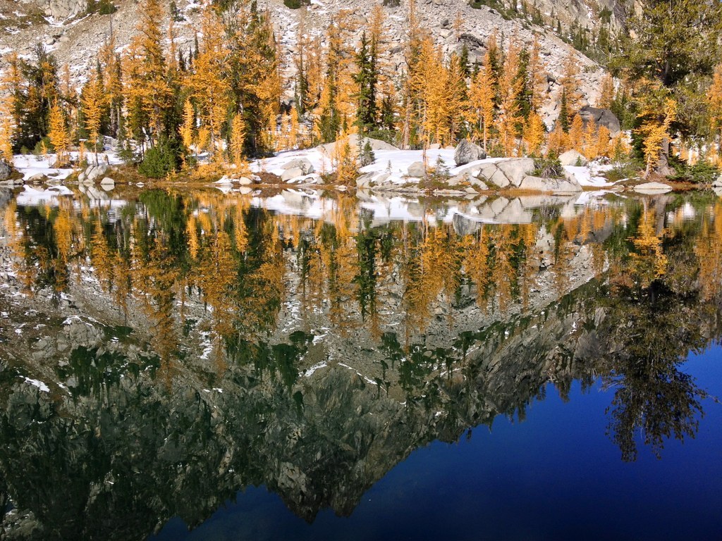
At the lake, photo opportunities abound. Granite, larches, and the water full of glacial till make for stunning photographs. There are also plenty of observation points available--look down on Horseshoe Lake and Lake Stuart, from a craggy rock outcropping, or gaze across the valley to Mount Stuart and the other rocky massifs that form the head of the valley.
WTA Pro Tip: Snow lingers here for much of the year, so expect to run into some, whether on your way to the lake, or as you wander in the meadows around it. As always, be aware of Leave No Trace ethics, and tread carefully on exposed alpine meadows.
Horseshoe Lake

-
 Length
- 16.0 miles, roundtrip
-
 Elevation Gain
- 2,928 feet
-
 Highest Point
- 6,300 feet
Parking Pass/Entry Fee
Northwest Forest Pass
A couple miles beyond Lake Stuart and a few hundred feet up lies Horseshoe Lake--a stunning, silent lake that makes for an excellent day trip for those lucky folks who get to camp at Lake Stuart. It’s also attainable as a day hike, but you’ll want to get an early start.
Continue reading
Hiking Horseshoe Lake
Map & Directions
 Trailhead
Before You Go
Parking Pass/Entry Fee
Northwest Forest PassWTA Pro Tip: Save a copy of our directions before you leave! App-based driving directions aren't always accurate and data connections may be unreliable as you drive to the trailhead.
Getting There
Drive Hwy 2 to milepost 99, found on the western edge of the Bavarian village of Leavenworth. Turn south onto Icicle Creek Road, paved with the occasional treacherous pothole (keep an eye out).
Turn left after 8.5 miles onto Eightmile Road, and continue on this dirt road for 3.8 miles to a large parking lot and the trailhead. The trail becomes washboarded as the season progresses, so high clearance vehicles are recommended. A toilet is available at the trailhead.


