Trails for everyone, forever

Home Go Hiking Hiking Guide June Lake

June Lake

South Cascades > Mount St. Helens
46.1372, -122.1568 Map & Directions
Length
2.86 miles, roundtrip
Elevation Gain
445 feet
Highest Point
3,140 feet
Calculated Difficulty About Calculated Difficulty
Easy/Moderate
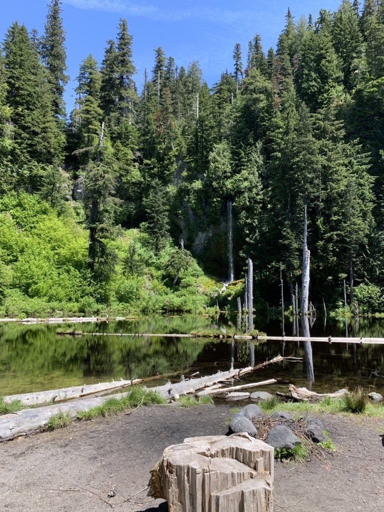
Quiet little June Lake. Photo by naturegirlangie. Full-size image
Saved to My Backpack

This sweet little hike on the south side of Mount St. Helens is a good destination for families seeking a short day hike, but it is also one access point for the round-the-mountain Loowit Trail, and a popular snowshoeing location, so it sees a fair amount of traffic year-round. Continue reading

  • Dogs allowed on leash
  • Good for kids
  • Lakes
  • Mountain views
  • Ridges/passes
  • Waterfalls
  • Wildflowers/Meadows
  • Wildlife

Parking Pass/Entry Fee

None
Rating
3.78 out of 5

(9 votes) Log in to rate

Hiking June Lake

The trail begins at the edge of a paved parking area just off Forest Road 83. An information kiosk at the edge of the lot has a map of the Mount St. Helens National Volcanic Monument as well as information for visitors; if you haven't already got a map in your pack, snap a shot of this map to carry with you as you hike. 

A brown sign with arrows clearly marks the start of the trail leading toward June Lake Ski Trail and the 1.5-mile-long Pika Ski Trail. This trail provides both a family-friendly hike and the shortest access to the Loowit Trail (but please keep in mind that the June Lake parking area is day-use only, so overnight backpackers on the Loowit Trail will need to access the trail elsewhere), making this a well-traveled trail for day hikers and snowshoers.

Climb gently, starting at June Creek and working your way in and out of second-growth forest. You will continue along or above the creek, which can be heard in its canyon below. The trail is primarily dirt, sand and rocks with some roots and log steps along the way.  Along the trail, depending on the season, you may see ferns, huckleberry bushes, wild strawberries, lupine, trillium, avalanche lilies or beargrass, while Mount St. Helens plays peek-a-boo through the trees to your left.

A mile in, the trail descends gradually and crosses a bridge. Just past the bridge, you will come to the unsigned intersection on the left for Pika Ski trail. At this intersection, continue forward on the trail toward June Lake. Just before you get to the lake, the trail opens up to an area of pumice soils with short trees and rocks. Here, the June Lake Trail continues ahead and climbs steeply to connect with the Loowit Trail. Since you're heading to June Lake, turn right, making your way through the trees to the lakeshore.

Sitting pretty at 3,140 feet, June Lake is a charming little lake formed by a 2,000-year-old lava flow, which blocked June Creek, a tributary of Swift Creek. The cool, clear water is lovely on a sunny day, dotted with logs growing small shrubs and trees, which cast reflections on the water. 

The sound and sight of a 70-foot waterfall across the lake adds magic to the area as it spills over a basalt cliff onto a mass of bright green mossy rocks. Smaller waterfalls cascade down the rocks on either side as a bald eagle soars above. Peer into the water along the silty lake bottom and you may see Cascade frogs, periwinkles and salamanders. It's a perfect place to have a picnic before returning the way you came or continuing on to other connecting trails. 

Toilet Information

  • No toilet at trailhead

More information about toilets

WTA worked here in 2022, 2018, 2016, 2015 and 2010!

Hike Description Written by
Angie Regensburg, WTA Correspondent

June Lake

Map & Directions

Trailhead
Co-ordinates: 46.1372, -122.1568 Open in Google Maps

Before You Go

The parking lot is day-use only. Overnight backpackers will need to use another trailhead to access the Loowit trail.

See weather forecast

Parking Pass/Entry Fee

None

WTA Pro Tip: Save a copy of our directions before you leave! App-based driving directions aren't always accurate and data connections may be unreliable as you drive to the trailhead.

Getting There

From Woodland, take exit 21 from I-5 and drive east on SR 503 for 29 miles to Cougar. Continue east on SR 503 (which becomes Forest Road 90) for 7 miles. Turn left onto FR 83. Although paved, the road has potholes and some major slumps so drive attentively. Follow FR 83 road for 7 miles to the signed trailhead turnoff on the left. Go 0.2 mile to the trailhead. The paved parking area has room for 8 vehicles. Overflow parking is on gravel and dirt.

Note: The parking area is signed to warn backpackers on the Loowit Trail not to leave their vehicles here overnight or they will be ticketed.

More Hike Details

Trailhead

South Cascades > Mount St. Helens

June Lake (#216B)

Mount St. Helens National Volcanic Monument

Guidebooks & Maps

Day Hiking: Mount St. Helens (Romano & Theisen - Mountaineers Books)

Day Hiking: South Cascades (Nelson & Bauer - Mountaineers Books)

The Disabled Hiker’s Guide to Western WA and OR (Syren Nagakyrie)

Green Trails Mount St. Helens National Volcanic Monument No.332S

Buy the Green Trails Mount St. Helens NVM No. 332S map

You can improve or add to this guidebook entry!

June Lake

76 Trip Reports

Hiked here recently?

Submit a trip report!
 
Trip Reports