
Get up close and personal with an enchanting glacier-sculpted landscape at Olympic National Park’s Lake Angeles.
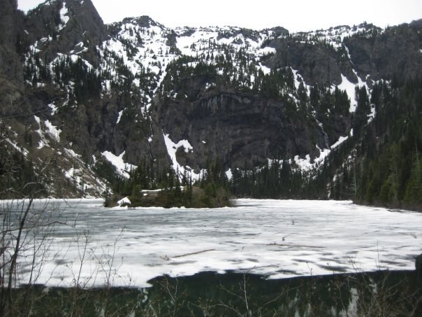
Over thousands of years, glaciers have carved away at the Olympics, leaving behind smoothed rocks, sharp ridges and lake-filled basins such as that of Lake Angeles in Olympic National Park. This teardrop-shaped 20-acre lake, filling a deep glacial cirque, is one of the largest alpine lakes in the Olympics. At the center of the lake, an island sits amid the emerald waters as cascades stream down the surrounding rocky walls, making for an idyllic hiking getaway.
Just a few miles from Olympic’s Heart O’ the Hills Campground, the Lake Angeles Trail steadily climbs 2,300 feet in 3.5 miles. The well-worn path starts on a moderate grade and travels through shaded second-growth forest. Uniform rows of dense hemlock are evidence of a fire that swept through the area more than a century ago. Ferns and fungi dot the landscape. Early-season blooms include trillium and Indian-pipe.
As you climb, the trail crosses a footbridge over Ennis Creek and continues climbing the divide between the Ennis and Lake Creek drainages. Above Ennis Creek the forest grows considerably drier, and vegetation starts giving way to mosses, rock and stunted alpine vegetation. The grade levels near a pond and large meadow. This is a good place to catch your breath and watch for black-tailed deer and ruffed grouse.
Arriving at the lake, views of Klahhane Ridge and Mount Angeles tower high overhead. Several campsites exist at the north end of the lake, inviting you to spend the night. (Permits required. Visit the Wilderness Information Center in Port Angeles.) Please note, no campfires allowed. Spend your day basking in the scenery, or continue another 3 miles (and another 1,800 feet of elevation gain) to the Klahhane Ridge–Heather Park–Switchback junction.
Lake Angeles

-
 Length
- 7.4 miles, roundtrip
-
 Elevation Gain
- 2,350 feet
-
 Highest Point
- 4,196 feet
Parking Pass/Entry Fee
National Park PassPermits Required
Backcountry camping permit. Reserve online (fee)
Get up close and personal with an enchanting glacier-sculpted landscape at Olympic National Park’s Lake Angeles.
Continue reading
Hiking Lake Angeles
Map & Directions
 Trailhead
Before You Go
Parking Pass/Entry Fee
National Park PassPermits Required
Backcountry camping permit. Reserve online (fee)WTA Pro Tip: Save a copy of our directions before you leave! App-based driving directions aren't always accurate and data connections may be unreliable as you drive to the trailhead.
Getting There
From Port Angeles leave US 101 near milepost 249, following Race Street south 1.2 miles to Hurricane Ridge Road (Heart o' the Hills Parkway) and passing the Olympic National Park Visitors Center and Wilderness Information Center. Proceed on Hurricane Ridge Road for 5 miles. Just before the park entrance booth, turn right (west) to reach a large trailhead parking area.


