Trails for everyone, forever

Home Go Hiking Hiking Guide Layser Cave

Layser Cave

South Cascades > White Pass/Cowlitz River Valley
46.4615, -121.8600 Map & Directions
Length
0.25 miles, roundtrip
Elevation Gain
100 feet
Highest Point
2,400 feet
Calculated Difficulty About Calculated Difficulty
Easy
Heading out of Layser Cave. Photo by kokay. Full-size image
  • Dogs allowed on leash
  • Good for kids
  • Mountain views
  • Old growth

Parking Pass/Entry Fee

Northwest Forest Pass
Saved to My Backpack

The short Layser Cave interpretive trail is a quick detour off the main route south of Randle that transports visitors into the Gifford Pinchot National Forest. The trail takes just a half-hour to hike and provides a nice immersion into the human history of the area. Continue reading

Rating
2.89 out of 5

(9 votes) Log in to rate

Hiking Layser Cave

The short Layser Cave interpretive trail is a quick detour off the main route south of Randle that transports visitors into the Gifford Pinchot National Forest. The trail takes just a half-hour to hike and provides a nice immersion into the human history of the area.

The trailhead is inconspicuous at a curve in the road about 1.6 miles in from Forest Road 23. The trail drops down gently, via a set of wooden stairs that lead to a rolling trail through ferns. It's an eighth of a mile before you reach a view of the Cispus Valley and Mount Adams as well as the Dark Divide peaks: Tongue Mountain and Juniper Ridge.

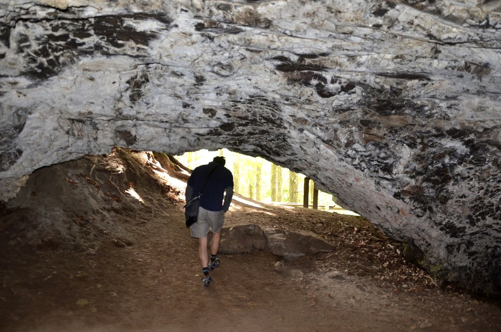
Past the viewpoint, the trail slopes slightly upward to the caves entrance, where an interpretive sign indicates that Native Americans hunted deer and elk, driving them into a box canyon. Rediscovered by Tim Layser in 1982, it is one of the most extensive archaeological sites in this part of the state.

The cavern itself is small -- just 40 feet by 60 feet. Let other visitors explore if you're here with other visitors. And of course, be sure to pack out everything you pack in.

Obsidian arrowheads from Oregon hint at evidence of trade and early human migration, and animal bones and stone tools found in the cave have allowed archeologists to trace human presence here back nearly 7,000 years.

Toilet Information

  • No toilet at trailhead

More information about toilets

Layser Cave

Map & Directions

Trailhead
Co-ordinates: 46.4615, -121.8600 Open in Google Maps

Before You Go

See weather forecast

Parking Pass/Entry Fee

Northwest Forest Pass

WTA Pro Tip: Save a copy of our directions before you leave! App-based driving directions aren't always accurate and data connections may be unreliable as you drive to the trailhead.

Getting There

From Highway 12 in Randle, turn south on State Route 131 (signed Mount St. Helens). At 1 mile, turn left onto the Cispus Road (Forest Service Road 23). In 7 miles, turn left on Spur Road No. 083.

There will be a sign stating that your destination is one-quarter mile ahead, but the road you turn on doesn't actually have a sign for Layser Cave until one-quarter mile after you turn off. The hard-to-see trailhead is on a hairpin curve that goes up and to the left.

More Hike Details

Trailhead

South Cascades > White Pass/Cowlitz River Valley

Layser Cave (#290)

Gifford Pinchot National Forest administered by Okanogan-Wenatchee National Forest

Guidebooks & Maps

Best Hikes with Kids: Western Washington and the Cascades Joan Burton (Mountaineers Books)

Green Trails McCoy Peak No. 333

Buy the Green Trails McCoy Peak No. 333 map

You can improve or add to this guidebook entry!

Layser Cave

33 Trip Reports

Hiked here recently?

Submit a trip report!
 
Trip Reports