Trails for everyone, forever

Home Go Hiking Hiking Guide Mount Storm King
WTA is a nonprofit that needs you

We're just as excited as you to get the summer hiking season started. We're psyched our website, app and work for trails help you get outside.

But we're a nonprofit that runs on donations from regular people. If everyone who visited this site this holiday weekend donated $9/month, it would fully fund our work for the next 2 years. Time spent outdoors is priceless, but every donation large or small helps us support those experiences for everyone. Thank you and happy hiking!


Please take 2 minS to chip in $9

link

Mount Storm King

Olympic Peninsula > Northern Coast
48.0582, -123.7892 Map & Directions
Length
4.0 miles, roundtrip
Elevation Gain
2,065 feet
Highest Point
2,600 feet
Calculated Difficulty About Calculated Difficulty
Moderate/Hard
View from the top of Mount Storm King's climber's trail. Photo by Anna Roth. Full-size image
  • Mountain views
  • Dogs not allowed
  • Summits
  • Fall foliage

Parking Pass/Entry Fee

None
Saved to My Backpack

Hikers flock to Mount Storm King for that signature shot, standing on a rocky outcropping above Lake Crescent. But it's a grind to get there, and the climb to the summit can be dangerous in bad weather. Luckily, there are several outcroppings about halfway to the top offering similar views. It's still a steep hike to get to them, but at least it's shorter. Continue reading

Rating
4.23 out of 5

(44 votes) Log in to rate

Hiking Mount Storm King

Hikers flock to Mount Storm King for that signature shot, standing on a rocky outcropping above Lake Crescent. But it's a grind to get there, and the climb to the summit can be dangerous in bad weather. Luckily, there are several outcroppings about halfway to the top offering similar views. It's still a steep hike to get to them, but at least it's shorter.

Start at the Storm King Ranger Station, on the southeast side of Lake Crescent. Hop on the wide trail that passes in front of the ranger station, and soon pass under Highway 101. Signed for Marymere Falls, the flat trail may lull you into a false sense of security. Make no mistake, your climb will come.

After just a few minutes of hiking (it'll clock in at about a half mile), arrive at huge boulder and a sign propped against it, pointing the way uphill via a 180-degree turn. This is your turnoff for Storm King. You might want to take a few layers off.

Shift it into low gear and begin your climb. Passing first through damp forest, the trail switchbacks steeply before flattening out moderately at a half mile from the turnoff. The forest opens, and becomes drier as you traverse through giant pines. Keep climbing, and you'll notice the forest around you changing. Pines give way (or at least share space) with madronas and manzanitas; hardy, twisted trees and shrubs with reddish bark that add color to the surrounding trunks of massive cedars and hemlocks.

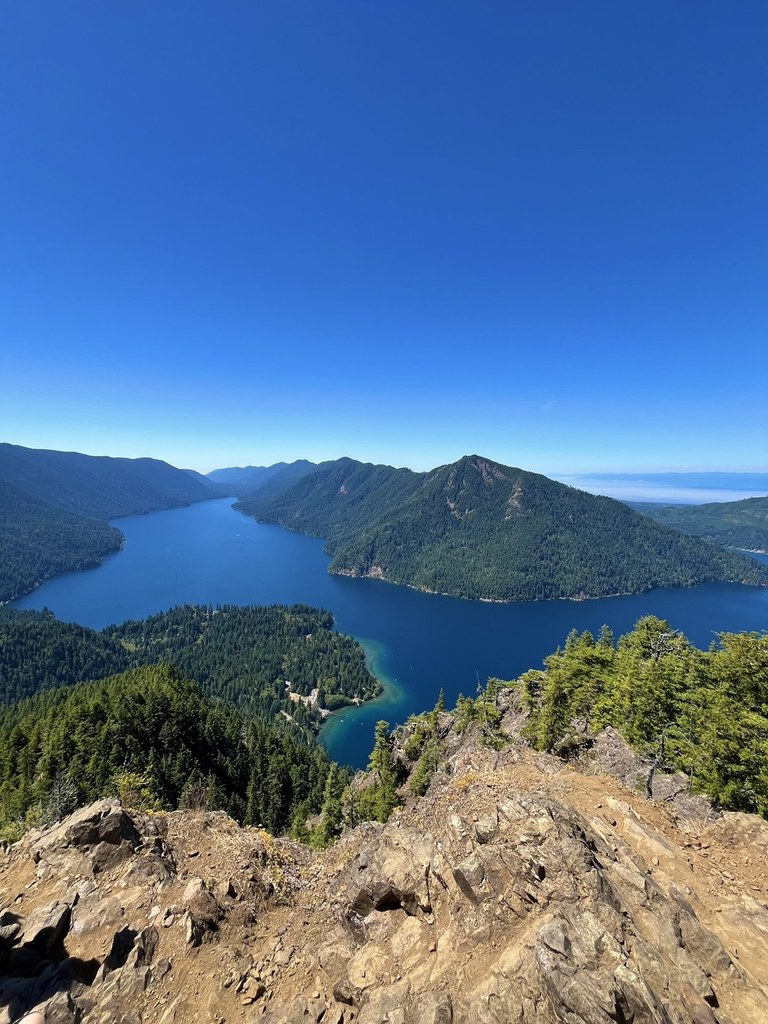
Begin looking for views when the madronas appear. There are several viewpoints, offering peek-a-boo views of both the Barnes Creek valley and the deep blue waters of Lake Crescent. At 1.3 miles, arrive at a shoulder where you have a through-the-trees view of Lake Crescent and the Strait of Juan de Fuca. This is the end of the maintained trail. If you want to continue, the trail does so, but it becomes gradually fainter and rougher, culminating in a climber's trail.

This climber’s trail is unmaintained and quite exposed. The ropes leading to the top are not installed or maintained by the land manager, so know that if you rely on them you are doing so at your own risk. Be aware of the risks and know your skill level before attempting this section.  And remember, don't climb up anything you wouldn't want to climb down.

Extending your trip: Back at the junction with Marymere Falls, turn left and go see the falls before heading back to the trailhead. It's a short hike, and the sweet little loop takes you past not only a gorgeous waterfall, but also wide, quietly burbling Barnes Creek. It's a nice cool down after the beating you got on Storm King.

Hike Description Written by
Anna Roth, WTA Staff

Mount Storm King

Map & Directions

Trailhead
Co-ordinates: 48.0582, -123.7892 Open in Google Maps

Before You Go

See weather forecast

Parking Pass/Entry Fee

None

WTA Pro Tip: Save a copy of our directions before you leave! App-based driving directions aren't always accurate and data connections may be unreliable as you drive to the trailhead.

Getting There

Drive west on Highway 101 from Port Angeles for 20 miles. At milepost 228 turn right into a large parking area signed for Lake Crescent and Marymere Falls. Continue 0.2 miles to the Storm King Ranger Station (on the shores of Lake Crescent).

The paved, horseshoe parking area is near the Ranger Station and restrooms, as well as a boat launch. Begin your hike on the Marymere Falls Nature Trail.

More Hike Details

Trailhead

Olympic Peninsula > Northern Coast

Mount Storm King (#49)

Olympic National Park

Guidebooks & Maps

Day Hiking: Olympic Peninsula (Romano - Mountaineers Books)

Custom Correct Lake Crescent–Happy Lake Ridge

Download a map to plan you hike

Buy the Green Trails Lake Crescent No. 101 map

You can improve or add to this guidebook entry!

Mount Storm King

354 Trip Reports

Hiked here recently?

Submit a trip report!
 
Trip Reports