
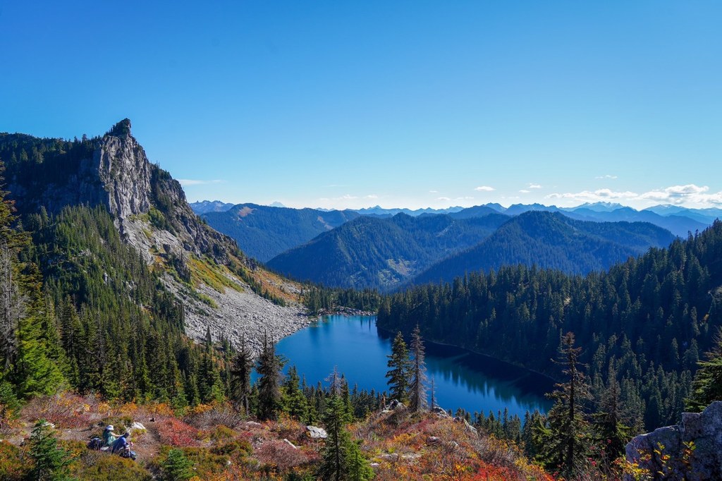
Mount McCausland delivers mountain views, lake views, and even solitude at the summit. The cost? The first three miles of the trail is easy, but the last half-mile to the summit is steep and occasionally brushy. Taking a break on that climb is no hardship though: the hillside is carpeted in berries and the views start early.
Start at the Smithbrook trailhead, an area brushy with neck-high fireweed. Proceed through the brush on a moderate grade and quickly arrive at a more open trail through a nice forest. Pass a rocky area with giant boulders as you ascend up moderately graded switchbacks. At 1.5 miles, arrive at a junction with the Pacific Crest Trail. If you go in September, bring some fresh fruit to share with the thru-hikers bound for Canada -- you'll see quite a few from here on out.
Head left (southbound) on the PCT, enjoying a relatively flat section of trail. The open forest provides periodic views of the rocky wall on the opposite side of the valley. This is a great place to teach young children the joy of hiking. The trail is lined with blueberries and huckleberries–the perfect fuel for going just a little further.
Approximately three miles from the trailhead, just before dropping to Lake Valhalla, you’ll find a turn-off for Mt. McCausland on your right. The trail is unmarked, but an obvious switchback heads up the hillside. You’ll quickly arrive in a meadow of low blueberry and huckleberry bushes. The sudden increase in the quantity of berries should give you an idea of the relative popularity of Mount McCausland versus Lake Valhalla and the PCT below you.
The switchbacks shorten and then disappear entirely as the trail charges straight up the mountain. Bring hiking poles; there are some big steps here and the trail surface is a little loose. Views of Lake Valhalla and Lichtenberg Mountain start right away, and you can still enjoy views from this trail even if you decide that attaining the summit is not part of your hiking agenda. Making it to the summit will grant additional views northeast of layers of mountains and tiny Dow Lake.
It is possible to access Mount McCausland from Steven's Pass, which saves you some miles driving, but adds on miles hiking. If you choose to access this mountain this way, you'll have a 12.6 mile roundtrip hike, and you will need a Northwest Forest Pass.
WTA Pro Tip: Save your energy, if possible, and when you’re done with Mount McCausland, head down to Lake Valhalla. It’s only half a mile from the junction and there is a nice sandy beach to relax on.
Mount McCausland

-
 Length
- 7.0 miles, roundtrip
-
 Elevation Gain
- 1,800 feet
-
 Highest Point
- 5,747 feet
Parking Pass/Entry Fee
None
Mount McCausland delivers mountain views, lake views, and even solitude at the summit. The cost? The first three miles of the trail is easy, but the last half mile to the summit is steep and occasionally brushy. Taking a break on that climb is no hardship, though: the hillside is carpeted in berries and the views start early.
Continue reading
Hiking Mount McCausland
Map & Directions
 Trailhead
Before You Go
Parking Pass/Entry Fee
NoneWTA Pro Tip: Save a copy of our directions before you leave! App-based driving directions aren't always accurate and data connections may be unreliable as you drive to the trailhead.
Getting There
From I-5, take Hwy 2 east. Four miles after the pass, the highway divides. Look for signs for FR 6700, and a few hundred yards past the divide, take a left turn onto FR 6700. This is also known as the Smithbrook Road. Be careful crossing the westbound lanes of Hwy 2 here: the visibility is poor and the road on the opposite of the highway is difficult to see.
The Smithbrook Road is in decent condition and suitable for passenger cars, though there are bumpy sections and a few isolated areas of potholes. Pass a couple of dispersed campsites and arrive at the trailhead at 2.6 miles. The parking area is large enough for approximately 20 cars, but there are no pit toilets.


