Trails for everyone, forever

Home Go Hiking Hiking Guide Oneonta Trail to Triple Falls

Oneonta Trail to Triple Falls

Southwest Washington > Columbia River Gorge - OR
45.5902, -122.0684 Map & Directions
Length
4.02 miles, roundtrip
Elevation Gain
700 feet
Highest Point
708 feet
Calculated Difficulty About Calculated Difficulty
Moderate
Triple Falls along the Oneonta Trail is a great dayhike destination. Photo by Anna Roth. Full-size image
  • Dogs allowed on leash
  • Fall foliage
  • Ridges/passes
  • Rivers
  • Waterfalls

Parking Pass/Entry Fee

None
Saved to My Backpack

Lined with waterfalls, stunning basalt cliffs and plenty of spots to turn around, the Oneonta Trail is a wonderful destination for a day hike, and even includes campsites for backpacking. However, the trail was part of the Eagle Creek Fire, so the upper section of the trail is in a former burn; unideal to hike in windy conditions. Continue reading

Rating
5.00 out of 5

Hiking Oneonta Trail to Triple Falls

This long, steep trail is one of the most challenging routes that leads to Larch Mountain, 7.7 miles away. Luckily, Triple Falls, just 1.7 miles into the trail, is one of the biggest draws of this hike, and a perfectly reasonable destination for most. And for those who want to go a little further on, there's a bridge at 3.06 miles with a shaded boulder field that would offer a 6.12 mile trip with about 1500 feet of elevation gain.

To reach Triple Falls, from the trailhead, switchback up the Horsetail Falls trail for 0.2 miles to a T intersection. Turn right, and follow Horsetail Falls west. For a mile, you'll traverse just above the Columbia River Historic Highway, passing Ponytail Falls and Middle Oneonta Falls before connecting with the Oneonta Trail.

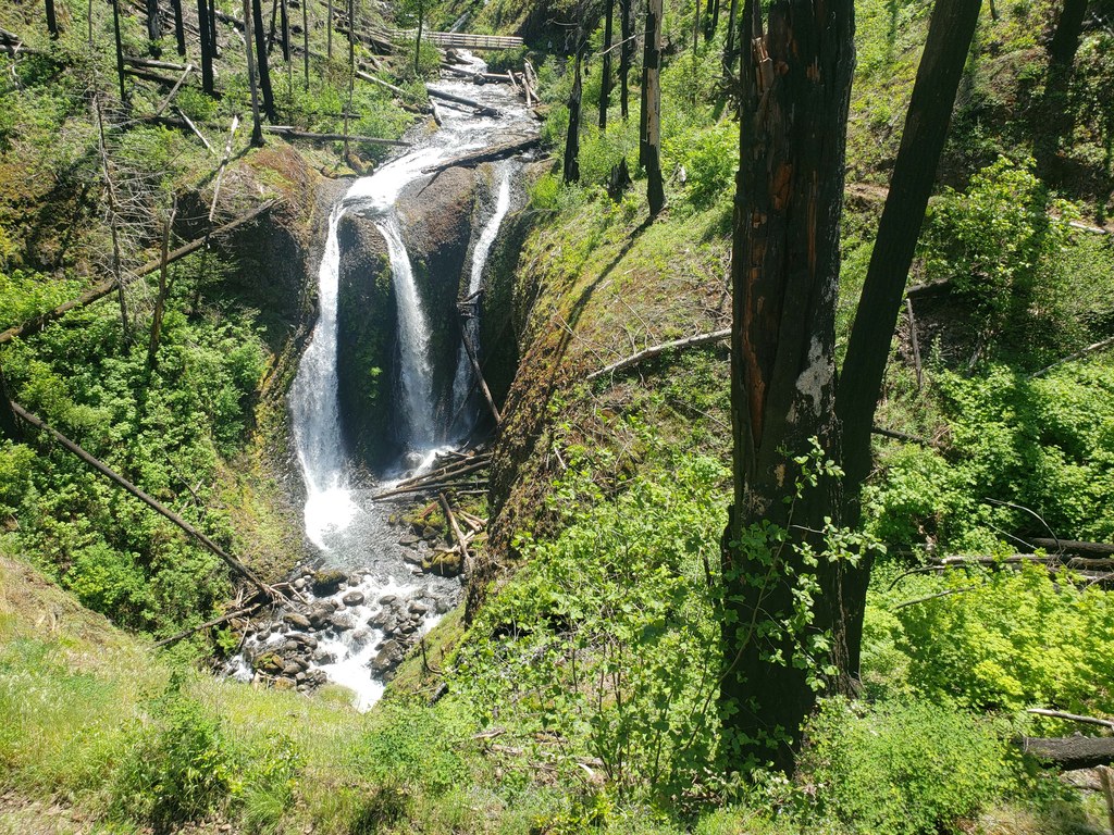
At the intersection with the Oneonta trail, head uphill (left). Now you're on a moderately-steep and relatively exposed, rocky trail. Keep kids close and dogs leashed here; the trail has steep dropoffs through this section. Its about another mile to Triple Falls, which you will see well before you arrive to where the trail crosses the river.

Before you arrive at the crossing for Triple Falls, there's a nice viewpoint of the waterfall, but be careful with your footing in this area.

If you want to continue past Triple Falls, continue over the river and head upstream again. The trail here becomes a little brushier and stays closer to the river for a little more than a mile to a river crossing with a bridge and a nice shaded boulder field, great for snacks.

Continue past the bridge and in just about 0.2 miles arrive at a camping area and intersection with the Horsetail Creek trail. Past this intersection, its 2.2 fairly steep miles to a junction with the Franklin Ridge trail. From here, you can continue along the Franklin Ridge trail to loop up with the Larch Mountain Trail, or you can continue on the Oneonta Trail for 2.3 miles to the summit of Larch Mountain.

Toilet Information

  • No toilet at trailhead

More information about toilets

Oneonta Trail to Triple Falls

Map & Directions

Trailhead
Co-ordinates: 45.5902, -122.0684 Open in Google Maps

Before You Go

See weather forecast

Parking Pass/Entry Fee

None

WTA Pro Tip: Save a copy of our directions before you leave! App-based driving directions aren't always accurate and data connections may be unreliable as you drive to the trailhead.

Getting There

From Portland, drive east on I-84 to Bridal Veil, Exit 28. Continue on the off ramp to the intersection with the historic highway and turn left. Continue 6 miles to the parking area; a small pullout on the south side of the highway.

From Hood River, drive west on I-84 to exit 35. Continue west on the historic highway about 1.5 miles to the parking lot which is a small pullout on the south side of the highway.

More Hike Details

Trailhead

Southwest Washington > Columbia River Gorge - OR

Oneonta Trail (#424), Horsetail Falls (#438)

Columbia River Gorge National Scenic Area

You can improve or add to this guidebook entry!

Oneonta Trail to Triple Falls

9 Trip Reports

Hiked here recently?

Submit a trip report!
 
Trip Reports