

If you’re contrarian by nature, you’ll appreciate the Paul Peak Trail, which flouts convention at every turn. Instead of climbing from the start, it drops into a lush forest. And instead of topping out at some show-stopping panorama, it ends unceremoniously, 3.1 miles from the start, at its junction with the Wonderland Trail. Indeed, Paul Peak Trail never climbs its namesake, skirting its flank instead.
But you don’t have to prefer the road less traveled to savor what Paul Peak Trail has to offer: an old-growth forest, an uncommon view of Mount Rainier, and a fair amount of solitude, particularly for a hike inside Mount Rainier National Park.
The trailhead is situated at a tidy parking lot that, along with accommodating about eight to ten vehicles, boasts two unisex toilets and several trash and recycling receptacles. Once you’ve displayed your national park pass or receipt on your dashboard, head downhill on the soft, well-groomed trail. You’ll drop about 250 feet in the first half mile or so before reaching the sturdy log bridge that crosses lively Meadow Creek. In this first part of the hike, ancient firs and hemlocks tower over a mossy understory of classic Pacific Northwest plants, including salal, Oregon grape, sword ferns, and trillium.
Once you cross Meadow Creek, the path becomes more undulating and even gains ground in places. Douglas squirrels and garter snakes scurry for cover among mossy boulders and decomposing logs teaming with life.
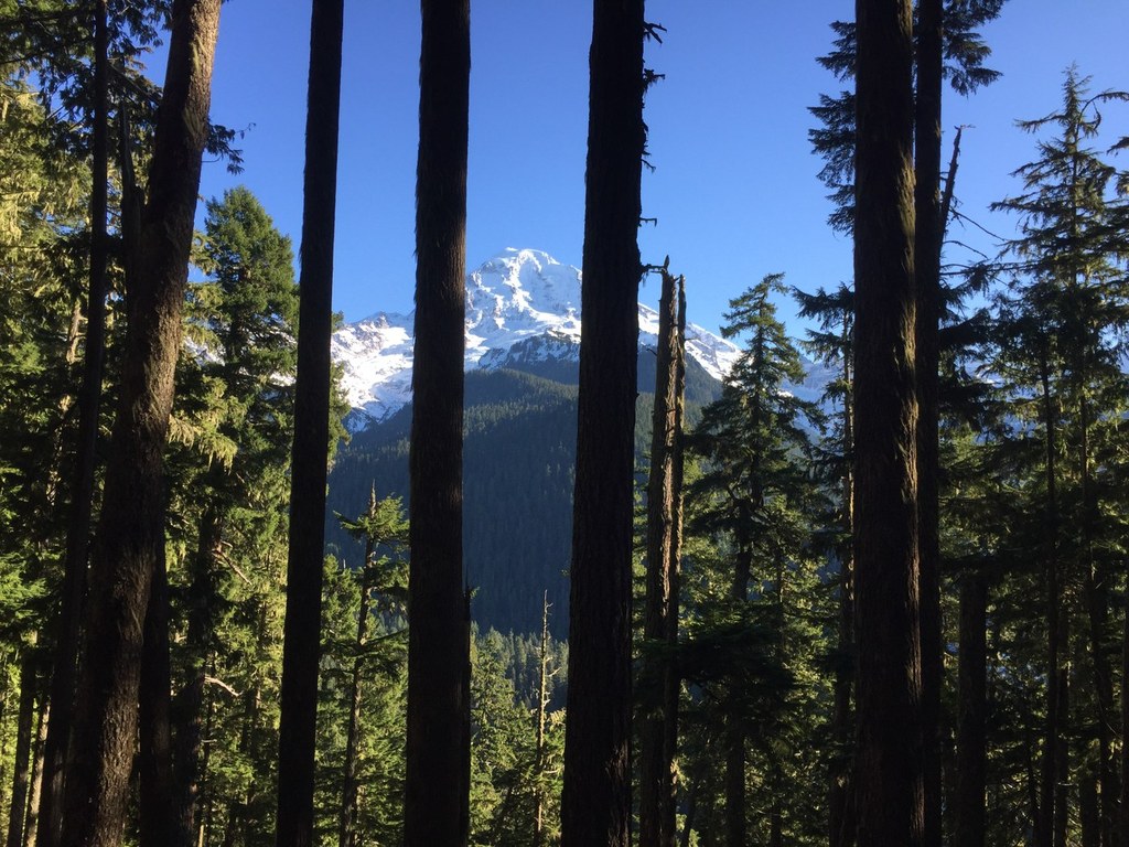
As the forest thins, you begin a long series of gentle, gradually descending switchbacks. Here, on Paul Peak’s sturdy flank, you’ll encounter the scattered debris, still evident, from a powerful 2004 windstorm. Snags and blowdowns litter the landscape. But along with unleashing a fair amount of destruction, the storm opened up a succession of views of Mount Rainier. Even if you’re an old hand when it comes to the mountain, you’ll find this view of Mount Rainier’s northwest face unique.
Several switchbacks later, you’ll reach a signed junction where Paul Peak Trail meets the Wonderland Trail and the two trails form a T. Since this is officially the end of the Paul Peak Trail, you can turn around here at the 3.1-mile mark and return the way you came, totaling 6.2 miles round-trip. Or you can take a right on the Wonderland Trail and continue your descent; Mowich River is less than a half mile away. At the river, take a moment to enjoy a well-earned rest. Grab a seat on a beached log and picnic alongside the ants. Those with camping gear can continue on to a campsite on the other side of the river, assuming the bridge is in working order and safe to cross.
When you’ve had your fill of the river’s soothing lullaby, turn back for the return trip to the parking lot. Yes, it’s mostly uphill. But you’ll be surprised at the gentle grade. In fact, shaded by all those trees and distracted by the local flora and fauna, you’ll hardly break a sweat.
WTA Pro Tip: Looking to extend your hike significantly? When you reach the junction with the Wonderland Trail, take a left and head back uphill toward Mowich Lake. The campground is 3.2 miles away. Not far enough? Just before you reach the lake, take a right at the Y and connect up with the trail to Spray Park. Miles of trails and stunning scenery await you. If you plan on camping, get a permit before you start out!

 Trailhead


