Trails for everyone, forever

Home Go Hiking Hiking Guide Redlining Heritage Trail - Pioneer Square

Alert: On Oct. 1 the federal government began a partial shutdown that will impact National Parks, National Wildlife Refuges and U.S. Forest Service lands in Washington. Here's the latest information we have for hikers and campers


Redlining Heritage Trail - Pioneer Square

Puget Sound and Islands > Seattle-Tacoma Area
47.5993, -122.3324 Map & Directions
Length
1.1 miles, roundtrip
Elevation Gain
25 feet
Highest Point
10 feet
Calculated Difficulty About Calculated Difficulty
Easy
  • Dogs allowed on leash

Parking Pass/Entry Fee

None
Saved to My Backpack

A short one-mile loop in the Pioneer Square neighborhood of Seattle outlining the redlined neighborhood in the area. Continue reading

Rating
0.00 out of 5

(0 votes) Log in to rate

Hiking Redlining Heritage Trail - Pioneer Square

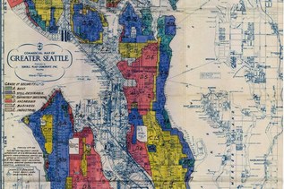
Part of a much larger 14-mile route, this section of the Redlining Heritage Trail encircles the Pioneer Square neighborhood of downtown Seattle.

This section begins at the National Park Service Klondike Gold Rush museum site on Jackson and 2nd. Turn left towards the water, and walk a block to S. Main street, then turn north and walk through Occidental Square Park. 

Turn left (again, towards the water) and walk a block and a half to the water. This site marks the former Native American restricted pier, the only place that Native people were allowed to haul out canoes and live in the city after 1865.

Double back and walk east along Washington Street 6 blocks to 2nd Ave S. Before you turn right, take a look across the street at the Chief Seattle Club, which provides housing and programming for Native people in Seattle today. 

Continuing on, it's one block down to the ILWU warehouse, built in 1900, it no longer houses ILWU, but the union is still active today. The corner of S Jackson and 4th Street marks the next landmark, the Canton Building, built by Chin Gee Hee in 1889 (one of the first to go up after the Seattle fire. It has been many businesses over the years, but it's one of the last piece of Seattle's early Chinatown. 

Look across Jackson at the clock tower and large brick building of King Street Station, the final stop on this leg of the Redlining tour. For many, this was their introduction to the city of Seattle, whether they were coming for the gold rush, as train porters or as day laborers.

Toilet Information

  • No toilet at trailhead

More information about toilets

Wheelchair Accessibility

Pioneer Square has sidewalks throughout, but the streets are rugged and uneven. Wheelchair users may need assistance or power chairs to navigate steep curb cuts or uneven sections of asphalt along this route.

Hike Description Written by
Anna Roth, WTA Correspondent

Redlining Heritage Trail - Pioneer Square

Map & Directions

Trailhead
Co-ordinates: 47.5993, -122.3324 Open in Google Maps

Before You Go

See weather forecast

Parking Pass/Entry Fee

None

WTA Pro Tip: Save a copy of our directions before you leave! App-based driving directions aren't always accurate and data connections may be unreliable as you drive to the trailhead.

Getting There

Begin your route at the Klondike Historic Gold Rush Museum on 2nd and Jackson.

More Hike Details

Trailhead

Puget Sound and Islands > Seattle-Tacoma Area

City of Seattle

You can improve or add to this guidebook entry!

Redlining Heritage Trail - Pioneer Square

1 Trip Report

Hiked here recently?

Submit a trip report!
 
Trip Reports