
Starting at a little under 7,000 feet in elevation and never dropping below 6,200 feet, your hike on Buckskin Ridge will provide miles of dramatic views.
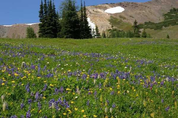
Get to know the area by trying to identify nearby peaks and the bright array of colorful wildflowers. Revel in Indian paintbrush, yellow aster, lupine, and countless other varieties as you gaze upon the lush fields below you. In autumn, stately larch groves add their color to the landscape, and in spring, babbling brooks accompany hikers on their way.
From the roadside trailhead, 100 feet of elevation gain awaits you; the elevation gain and loss is constant on this hike, but that just allows for constantly varying angles of the beauty that surrounds you.
As you head up the ridge, enter the majestic Pasayten Wilderness. The route takes you along Gold Ridge drops about two hundred feet along a nicely graded trail through talus slopes. Just past the talus, enter wildflower-filled meadows, larch groves and subalpine forest.
Dayhikes of this sort are hard to come by because it starts so high and stays high, keeping you in the subalpine zone for the entirety of the hike, but chances are you won’t meet many people on the trail. Stay on Gold Ridge for as long as you’d like. There’s no hurry to speed to your destination -- the journey is as enthralling as a hike can be.
It's about 4.6 miles to the quaint little lake, a shallow pool that sits among stubby firs in a grassy meadow. Small trout make their home here, so anglers, don’t forget your fishing rod.
When you've cooled off at the lake and taken in as many sights as you can, head back to your car, enjoying ever more new views of the wilderness around you.
WTA Pro Tip: Stay at the Harts Pass campground before or after your hike. Be warned that there is no water, and you must bring your own firewood, but the sunsets and sunrises here are not to be missed.
Silver Lake

-
 Length
- 10.0 miles, roundtrip
-
 Elevation Gain
- 2,800 feet
-
 Highest Point
- 6,950 feet
Parking Pass/Entry Fee
Northwest Forest Pass
There are few places where you start your hike at 7,000 feet without any effort. Spectacular views, a dizzying array of wildflowers and larch groves -- this hike is simply gorgeous and a pure Pasayten experience.
Continue reading
Hiking Silver Lake

WTA worked here in 2018!
Map & Directions
 Trailhead
Before You Go
Parking Pass/Entry Fee
Northwest Forest PassWTA Pro Tip: Save a copy of our directions before you leave! App-based driving directions aren't always accurate and data connections may be unreliable as you drive to the trailhead.
Getting There
Take the North Cascades Highway to the turnoff for Mazama, just past milepost 180. Turn left at the intersection and follow the road to Harts Pass. The pavement ends in a little more than 6 miles, where the road becomes Forest Road 54. Follow this narrow road for 12 miles to Harts Pass, driving carefully and watching for oncoming traffic or wildlife. Pass the campground and guard station, and veer right toward Slate Peak, then proceed about 2 miles to the trailhead at the second switchback.


