
The Spider Gap - Buck Creek Pass Loop penetrates some of the most glorious country of the Glacier Peak Wilderness. Take a long weekend and enjoy some of the best backcountry in the state. Along the way, you'll see massive wildflower meadows, glaciers, alpine lakes, high mountain passes and supreme views of Glacier Peak.
Start along the popular Spider Meadow-Phelps Creek trail (also written up here as a day hike). Follow Phelps Creek for a long, but relatively easy five miles to the mile-long expanse of Spider Meadow. This is a favorite destination of weekend backpackers, so you may wish to camp further along — either in Phelps Basin at the far end of the meadow or in one of the camps near the tarns at the base of Spider Glacier.
At the end of Spider Meadow, choose the steep trail to the left to ascend to Upper Lyman Lakes. It's steep, but it's just a warm-up for the most harrowing part of the loop. Bringing trekking poles or an ice ax is highly recommended for climbing up Spider Glacier (if the snow has melted out, you can also pick your way to the right of the glacier over rocks) to Spider Gap (your high point at 7100 feet).
There is a boot-beaten path from the Gap as you head down to Upper Lyman Lakes, which can be quite treacherous when snow or ice-covered. Make sure to time your trip late enough in the summer to make it down safely -- or turn around at Spider Gap. Note some GPS tools (Gaia) show a high route (trail 1256.4) off the top of the Gap, re-joining the trail at Lower Lyman Lakes campsite. Despite this, the high trail runs out with no plausible path off the ridge. It should be avoided unless hikers are willing to scramble and have route finding skills.
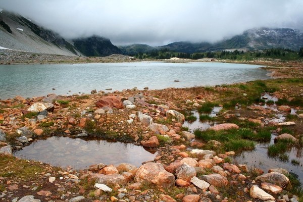
There are plenty of campsites around Lyman Lake (elev. 5500 feet), and it provides a good basecamp for exploring the area. Take short side trips to Lyman Falls or hike down the trail to large Hart Lake and relax on its pebbly shore. Or push on -- there's still plenty to see on the loop. Cloudy Pass is another 1.5 miles past Lower Lyman Lake, and Suiattle Pass is another mile beyond that. Note that water may be limited in this area late in summer, so be sure to stock up at Lyman Lakes.
By the time you reach Suiattle Pass, the views have really opened up. Enjoy in-your-face views of the wilderness around you, especially of the mountain it's named for, Glacier Peak. At the pass, you join with the Pacific Crest Trail (PCT) for a few miles of sensory overload. One side trip to seriously consider is Image Lake. While it's about a seven-mile roundtrip detour, the path and the destination are completely worth it. Photographers from far and wide have been known to make the trek to Image Lake to capture Glacier Peak reflected in its calm waters.
Whether you take the detour or save Image Lake for another day, continue on the loop, following the PCT and crossing Miners Creek until you reach a junction with Trail 789, which leads to Buck Creek Pass. You'll be tempted again with side trips up Middle Ridge and Flower Dome, both worthy destinations.
After exploring Buck Creek Pass, it's a long 9.6 miles back to the trailhead near the Phelps Creek Campground and another three miles along the road back to your car.
Spider Gap - Buck Creek Pass Loop

-
 Length
- 34.0 miles, roundtrip
-
 Elevation Gain
- 7,650 feet
-
 Highest Point
- 7,100 feet
Take a long weekend and enjoy some of the best backcountry in the state on this long loop hike. Along the way, you'll see massive wildflower meadows, glaciers, alpine lakes, high mountain passes and supreme views of Glacier Peak.
Continue reading
Hiking Spider Gap - Buck Creek Pass Loop

WTA worked here in 2011 and 2010!
Map & Directions
 Trailhead
Before You Go
Parking Pass/Entry Fee
Northwest Forest PassWTA Pro Tip: Save a copy of our directions before you leave! App-based driving directions aren't always accurate and data connections may be unreliable as you drive to the trailhead.
Getting There
From Everett head east on US 2 for 85 miles to Coles Corner. (From Leavenworth travel west on US 2 for 15 miles.) Turn left onto State Route 207 (Lake Wenatchee) and proceed 4.2 miles to a Y intersection after crossing the Wenatchee River. Bear right onto the Chiwawa Loop Road, and after 1.3 miles turn left onto the Chiwawa River Road (Forest Road 62). Proceed for 22 miles (the pavement ends at 10.8 miles) to a junction. Bear right onto FR 6211 and proceed for 2.3 very rough miles to the trailhead at the road's end (elev. 3500 ft). The hike ends just north of the Phelps Creek Campground, requiring a 3-mile road walk back to your car at the end.


