Trails for everyone, forever

Home Go Hiking Hiking Guide Tamanawas Falls

Alert: On Oct. 1 the federal government began a partial shutdown that will impact National Parks, National Wildlife Refuges and U.S. Forest Service lands in Washington. Here's the latest information we have for hikers and campers


Tamanawas Falls

Southwest Washington > Columbia River Gorge - OR
45.3973, -121.5717 Map & Directions
Length
3.6 miles, roundtrip
Elevation Gain
650 feet
Highest Point
3,450 feet
Calculated Difficulty About Calculated Difficulty
Easy/Moderate
The falls. Photo by Ken Giesbers. Full-size image
Saved to My Backpack

This trail has easy access, is relatively flat and is only 3.6 miles round trip. The payoff is a broad and picturesque curtain of water, dropping 109 feet over a basalt ledge. Continue reading

  • Dogs allowed on leash
  • Good for kids
  • Old growth
  • Rivers
  • Waterfalls

Parking Pass/Entry Fee

Northwest Forest Pass
Rating
0.00 out of 5

(0 votes) Log in to rate

Hiking Tamanawas Falls

The trail starts out northbound on the East Fork Trail, crossing the East Fork of the Hood River, then, at ½ mile, comes to a junction. Continue straight, now on the Tamanawas Falls Trail, which crosses Cold Spring Creek on a stout bridge. From there, the trail climbs gently along the creek, mostly in forest. As you get close to a view of the falls, there is one rocky slide area where children may need assistance.

Originally called Giffords Falls, the falls were officially renamed in 1971. The current name derives from the Chinook word for “friendly guardian spirit.”

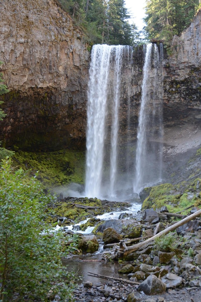
Tamanawas Falls crashes down onto rocks, creating a mist that the winds often carry toward the viewpoint. Still, this is a favorite spot to eat lunch. When finished, return the way you came.

Toilet Information

  • Toilet at trailhead

More information about toilets

Tamanawas Falls

Map & Directions

Trailhead
Co-ordinates: 45.3973, -121.5717 Open in Google Maps

Before You Go

See weather forecast

Parking Pass/Entry Fee

Northwest Forest Pass

WTA Pro Tip: Save a copy of our directions before you leave! App-based driving directions aren't always accurate and data connections may be unreliable as you drive to the trailhead.

Getting There

The trailhead is along state route 35 on the east side of Mount Hood. From the town of Hood River along the Columbia River, travel south on SR 35 for 24 miles. From Government Camp on the southwest side of Mount Hood, travel east on U.S. 26 for 2.5 miles then continue straight on SR  35 another 15 miles to the roadside trailhead.

More Hike Details

Trailhead

Southwest Washington > Columbia River Gorge - OR

Tamanawas Falls (#650A), East Fork (#650)

Mt. Hood National Forest / Hood River Ranger District

You can improve or add to this guidebook entry!

Tamanawas Falls

4 Trip Reports

Hiked here recently?

Submit a trip report!
 
Trip Reports