

Can't decide between walking along an ocean bluff with water stretched out for miles before you or wandering through forest under the drooping branches of moss-covered cedars? The Kettles Trail System on Whidbey Island offers you an opportunity to do both!
Hiking in the more than 35 miles of trails south of Fort Ebey State Park is like a Choose Your Own Adventure story; you can meander about for hours and never walk the same trail twice. This system is also linked to the Pacific Northwest Trail, which runs from Glacier National Park to Cape Alava, but for a good day hike, you can simply continue south to Coupeville and end your day with a nice dinner in town.
Overview
The trails have whimsical names like Hokey-Ka-Dodo, Whippersnapper, and Humpty Dump but others speak to the surrounding foliage: those branded Madrona Hill, Cedar Hollow, Salal Run and Alder Grove let you know what types of vegetation you'll be walking through. Others like Confusion, Windsucker Hill and Escape give you a clue as to their characteristics!
Most are an easy to moderate level, any steeper sections are brief. The highest point, about 200 feet above sea level is found on a knob close to the Madrona Hill and Confusion trails off the main Kettles Trail from SR 20 to Fort Ebey. The available online maps are a good guideline, but expect to find a few stray footpaths as you go along. These may be better marked on the kiosks and markers within the system.
There are bathrooms and water available within the state park but the trailheads on SR 20 do not have services. Maps are available on the National Park website or in Fort Ebey State Park itself. There are kiosks at trailheads and the trails are well marked. The trailheads along SR 20 are located on the west side between Libbey Road and run 1.3 miles south. If you're coming from the north from Coupeville, begin looking on the left at .7 miles from the overpass bridge over SR 20.
The gates at these trailheads are all marked with the Kettles name. of the trails are open to non-mechanical bikes and equestrian riders in addition to hikers but there is plenty of room to share. For hikers only, Kyle's Kettle Trail is an option on the north side of the trail system accessed best once you turn from Hill Valley Rd into Fort Ebey State Park proper.
The main Kettle Trail runs 0.75 miles from Coupeville along Highway 20. This section is paved until it turns and joins the other nature trails within the recreational area shared by Island County and the State Park. All the trails fall within the Ebey National Historical Reserve, part of the National Park System.
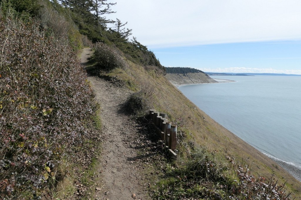
There are views of the saltwater shoreline from the Bluff Trail but most of the trails meander through the second growth forest of the reserve, also filled with lower foliage of Rhododendron and Oregon Grape. You can even add on some time in the old army gun batteries showcased within the state park or take a trail from the park down to the shoreline where you may glimpse some paragliders sailing down off the bluffs.
Remember when you get to where this trail overlooks the bluff to keep your eye out for bald eagles perched on the scraggly trees next to you as they look out for that day's dinner!
Geology
The Kettles Trail System is named after the geological features known as kettles, glacial depressions left in the landscape from the receding Vashon Glacier. Immense chunks of ice cleaved off and deposited on the terrain left depressions as the ice melted away. Most of these are now covered with trees and foliage, making them hard to distinguish but it is possible if you know what to look for. They look like ravines that curve up on all sides -- similar to an elongated bowl rather than run out on one or two sides like a funnel. The Cedar Grove Trail offers a great example of this.
 Trailhead


