Trails for everyone, forever

Home Go Hiking Hiking Guide Thomas, Blue and Tombstone Lakes
link

Thomas, Blue and Tombstone Lakes

South Cascades > Mount Adams Area
46.0057, -121.8391 Map & Directions
Length
7.0 miles, roundtrip
Elevation Gain
1000 feet
Highest Point
4780 feet
Calculated Difficulty About Calculated Difficulty
Moderate
Fall colors at Blue Lake. Photo by Susan Saul. Full-size image
  • Wildflowers/Meadows
  • Dogs allowed on leash
  • Established campsites
  • Good for kids
  • Lakes
  • Fall foliage

This heavily-used trail passes numerous lakes and meadows and is an excellent foray into the Indian Heaven Wilderness. Hikers will find amble opportunities for a lakeside lunch spot. Continue reading

Rating
2.75 out of 5

(8 votes) Log in to rate

Hiking Thomas, Blue and Tombstone Lakes

More than 20 lovely lakes and tarns lie alongside or just off this scenic hike into the Indian Heaven backcountry. You can visit five of the lakes clustered in the first mile on a hike that can be done even by families with small hikers. For a longer hike, ascend through the forest to a plateau dotted with Indian Heaven’s glorious huckleberry-filled meadows and lakes and tarns, to reach sapphire-hued Blue Lake.

The trail begins in a partially-logged area but soon climbs into uncut forest of western hemlock and silver fir. Reach the wilderness boundary at 0.5 mile. Soon, after 300 feet of elevation gain, the trail squeezes between Dee and Heather lakes on the left and Thomas Lake on the right. Designated campsites are on the east and west shores of Thomas Lake, the largest and most scenic lake of this group. It is stocked with brook trout.

Continue on the trail to a junction where the left fork is a short spur trail to Eunice Lake. The main trail begins to climb steeply up the ridge above Eunice Lake, which might be glimpsed through the trees. This trail was originally known as “Brader Way,” named for John Brader, an old sheepherder who grazed his flocks in the Indian Heaven high meadows until 1944.

The trail levels out and passes through the first of many meadows. The trail climbs again, passing an unmarked spur trail over the ridge to the right to Brader Lake. When you reach small Naha Lake on your right, you will know that most of the climbing is done. The trail soon leads out of the forest into heather and huckleberry meadows, with East Crater visible ahead above the trees.

At 2.1 miles, reach a well-signed, sharp right turn in the trail. Rock Lake is straight ahead through the trees, so you might want to pause here for a look.

The scenery from Rock Lake to Blue Lake is stunning, some of the finest Indian Heaven landscape. The trail proceeds southeast through a paradise of small lakes and park-like meadows. Natural earth mound gardens dot the meadows. Lake Umtux, on the right, is the largest and one of the few named lakes. There actually are 13 lakes located on or near the trail in the Umtux complex.

This landscape was created by the Indian Heaven volcanic field. Lava once flowed from the numerous volcanic cones, such as East Crater, that rise above the plateau.

At 2.7 miles, the trail descends into the forest and arrives at Sahalee Tyee Lake in 0.3 mile, losing 100 feet of elevation. This lake, more than 25 feet deep, is believed to be in the crater of an ancient volcano. This is an area where Native Americans built slow-burning fires in trenches, preserving berries for later use by drying them over the radiant heat. The lake’s name is translated loosely in Chinook Jargon as “the chief’s high, heavenly ground” and was the original name for the entire Indian Heaven country.

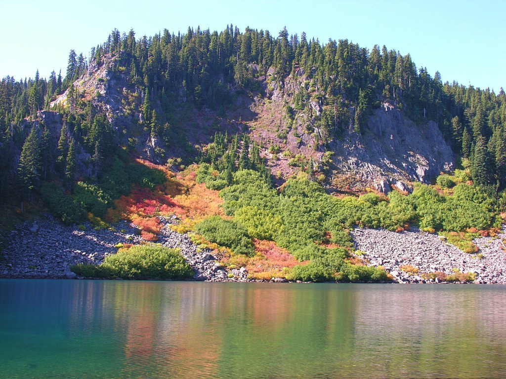
Descend another 0.2 mile to Blue Lake, backed by the cliffs of Gifford Peak, and in 3.3 miles, meet the junction with the Pacific Crest Trail at the southeast corner of the lake. Designated campsites are located around the lake.

If you want more hiking, check out small Tombstone Lake on a 0.3-mile spur trail off the PCT to the southeast of Blue Lake. The lake likely got its name from the rock jutting out of the small lake, which to some, resembles a tombstone you might see in an old cemetery.

Pro-Tip: Wait for the mosquitoes to diminish before visiting. In late summer and early fall, the area bursts with bountiful berries and vivid colors.

Hike Description Written by
Susan Saul, WTA Correspondent

Thomas, Blue and Tombstone Lakes

Map & Directions

Trailhead
Co-ordinates: 46.0057, -121.8391 Open in Google Maps

Before You Go

See weather forecast

WTA Pro Tip: Save a copy of our directions before you leave! App-based driving directions aren't always accurate and data connections may be unreliable as you drive to the trailhead.

Getting There

Directions from I-5

If heading north, take exit 21 for WA-503. Turn right onto Lewis River Road and continue for 0.8 miles until the traffic circle. Take the first exit to continue east on WA-503/Lewis River Road.

If heading south, take exit 22 for Dike Access Road. Take the third exit on the traffic circle to go east on Dike Access Road. At the next traffic circle, take the first exit to continue east on on Old Pacific Highway. Continue for 0.8 miles then make a slight left onto E Scott Ave. At the traffic circle, take the second exit to continue east on WA-503/Lewis River Road. 

Continue on WA-503 for 30.6 miles through Cougar until the road becomes NF-90. Continue on NF-90 for 19.5 miles as you pass along the north side of the Swift Reservoir, then take a right onto NF-51/Curly Creek Road. Continue on Curly Creek Road for 5 miles and then take a left onto NF-30/Wind River Highway. Go 1.5 miles then take a right onto gravel NF-6507. Continue on this road for another 4.2 miles before turning left at the junction with NF-65. The trailhead will be a half mile up on the right.

Directions from WA-14

Turn north from the WA-14 onto the Wind River Highway toward Carson. Continue for 14.3 miles then take a right onto NF-30/Wind River Highway, just past the Carson National Fish Hatchery. Continue on this paved two-lane road for 14.6 miles and then turn right onto NF-6507. Continue on this road for another 4.2 miles before turning left at the junction with NF-65. The trailhead will be a half mile up on the right.

Directions from US-12

Turn south onto WA-131 out of Randle. Continue for 2.7 miles as the road becomes NF-25. Continue for 42 miles, going over Elk Pass, until you reach the edge of the Swift Reservoir at Pine Creek, then take a left onto NF-90. Continue for 4.2 miles then take a right onto FR-51/Curly Creek Road. Continue on Curly Creek Road for 5 miles and then take a left onto NF-30/Wind River Highway. Go 1.5 miles then take a right onto gravel NF-6507. Continue on this road for another 4.2 miles before turning left at the junction with NF-65. The trailhead will be a half mile up on the right.

Trailhead Amenities: vault toilet, picnic table, garbage can, fee station (envelope) to purchase parking pass.

More Hike Details

Trailhead

South Cascades > Mount Adams Area

Thomas Lake (#111), Tombstone Lake (#55)

Gifford Pinchot National Forest, Mount Adams Ranger District

Guidebooks & Maps

Day Hiking: Mount Adams and Goat Rocks (Tami Asars - Mountaineers Books, 2014);

100 Hikes/Travel Guide: Northwest Oregon & Southwest Washington (William L Sullivan - Navillus Press, 2019)

Mount Adams Wilderness/Indian Heaven Wilderness/Trapper Creek Wilderness, US Forest Service, 2005

Buy the Green Trails Indian Heaven No. 365S map

You can improve or add to this guidebook entry

Thomas, Blue and Tombstone Lakes

32 Trip Reports

Hiked here recently?

Submit a trip report!
 
Trip Reports