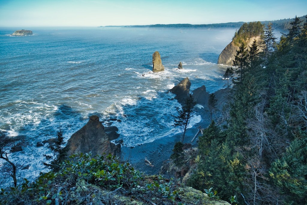

Bring a tide table and a good book on this scenic traverse of the wild Olympic Coast. While much of your hike will be across sandy beaches, there are several places that will require you wait for the tide to go out. Along the way, plan to climb up steep headlands with cable ladders, ropes and your hands and knees. The absolute elevation gain is minimal, but all of those ups and downs add up to nearly 3000 feet. It's a challenge, but a good one.
The best way to hike this stretch of coast is to leave one car at the Oil City trailhead and drive the other one to your start at Third Beach near La Push. Plan at least two - and even better - three days for your walk. Make sure you bring along an excellent map and heed all instructions about where to cross and when.
It's about a mile and a half through forest from the trailhead down to Third Beach. After crossing the beach, you will reach your first ladder to take you above Taylor Point. Watch your footing - it is slippery all along here when wet! And time your arrival back down at the beach for low tide. Scotts Bluff Camp is a great place to camp or push further to Strawberry Point.
Toleak Point beckons, along with some nice sea stacks. One of many photo opportunities along the way and also an excellent place to camp. Past Toleak there are some natural arches. At the second one, look for the ladder up the headland. At the top you will cross Goodman Creek, which runs high in spring. Back down on the beach is a lonely stretch of sand - you'll likely have it to yourself.
Finally, the last stretch requires waiting for low tide or heading up high to avoid the crashing waves - avoid round Hoh Head in any condition. As you approach the Hoh River, follow the Oil City Trail back to your car.
South Coast Wilderness Trail - Toleak Point

-
 Length
- 17.0 miles, one-way
-
 Elevation Gain
- 2,000 feet
-
 Highest Point
- 350 feet
Parking Pass/Entry Fee
NonePermits Required
Backcountry camping permit. Apply online (fee)
Bring a tide table and a good book on this scenic traverse of the wild Olympic Coast. While much of your hike will be across sandy beaches, there are several places that will require you wait for the tide to go out. Along the way, plan to climb up steep headlands with cable ladders, ropes and your hands and knees. It's a challenge, but a good one.
Continue reading
Hiking South Coast Wilderness Trail - Toleak Point

WTA worked here in 2010!
Map & Directions
 Trailhead
Before You Go
Parking Pass/Entry Fee
NonePermits Required
Backcountry camping permit. Apply online (fee)WTA Pro Tip: Save a copy of our directions before you leave! App-based driving directions aren't always accurate and data connections may be unreliable as you drive to the trailhead.
Getting There
From Port Angeles follow Highway 101 west for 55 miles to the junction with State Route 110 (signed Mora-La Push). From Forks, the junction is 2 miles north. Continue west on Highway 110. In 7.7 miles, at Quillayute Prairie, 110 splits. Take the left fork (La Push Road) and proceed 3.8 miles to the trailhead, located on the south side of the road. Privy available.
To reach the opposite trailhead at Oil City, head south on Highway 101 to between mile post 177 and 178, just north of the Hoh River. Turn onto Oil City Road, which is both paved and dirt in sections, to the very end. This trailhead has lots of parking and a privy.


