
Car Wash Falls, a waterfall that went right over the old road up the Stehekin valley, provided a nice rinse for cars when it was running low, but a crushing tumult of water when levels were high. In 2003, these falls pounded down on the road so hard it blasted a section of it out into the river, and the park service elected to leave the road washed out, moving all hikers onto a trail bypass on the Pacific Crest Trail towards Bridge Creek.
Hikers have always been able to bypass this road section, even when it was an option to drive into the upper valley. Now, this section is a must-do in order to access most trails in the upper valley.
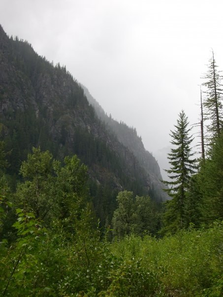
Beginning from High Bridge, hike along the road on a somewhat steep grade for a mile past Tumwater Camp. After another mile, cross the Stehekin River on a large bridge and hop onto the PCT northbound for Bridge Creek. The trail rolls moderately through beautiful forest and one remarkable section of old burn vibrant with magenta fireweed almost five feet tall. Soon though, it plunges back into dark forest, becoming slightly more rooty and rugged for another three miles until you arrive at Bridge Creek Camp.
This campground is open to horses, hikers, and groups, and a backcountry camping permit is required to stay overnight here. Please make arrangements through North Cascades National Park complex. The Pacific Crest Trail now rejoins the old roadbed for a time, and you’ll have the chance to walk side-by-side with your hiking partner — if you have one — as you make your way down the old road, which has been remarkably well preserved in the years since the washout.
Just up the road from Bridge Creek, a trail splits off. This is the Pacific Crest Trail as it continues north to Rainy Pass and eventually the trail’s endpoint in Manning Park, Canada. Making a left turn, follow the road and shortly arrive at the Goode Ridge trailhead. This trail to a former lookout tower is a burner, shooting up 4400 feet in just 5 miles, but the panorama from the summit is stunning.
Continue another three miles down the old road, enjoying periodic glimpses of the river. A trailhead 2.7 miles from the Goode Ridge trail is for Park Creek Pass, an epic jaunt along Park Creek and up into a wide, fairytale pass. This is another way to exit the valley; follow the Park Creek Pass trail long enough and you’ll wind up on Highway 20!
A few hundred yards up the road from Park Creek Pass is Flat Creek Camp and its accompanying trail. The campground here is quite large, but can only accommodates two large groups. Again, be sure to make arrangements with the National Park Service if you plan on staying here overnight.
From Flat Creek, it’s 3.7 miles more road walking before arriving at the end of the road. Cottonwood Camp is a large camp area that may be set up for the Stehekin Valley Tent-to-Tent trips.
From here, the road becomes an honest to goodness trail, which provides access to a handful of other campgrounds, Cascade Pass and Sahale Arm, Horseshoe Basin, and eventually, Highway 20.
WTA Pro Tip: Many trails along the Stehekin River Road can also be accessed from Highway 20. Consider making your visit to Stehekin a one-way trip – arrive via ferry and make arrangements to hike out and get picked up on the other side. Even better, consider starting from a Highway 20 trailhead and hiking into Stehekin – the Stehekin Pastry Company is a must-stop for hikers, particularly for those of you putting in lots of miles.
Upper Stehekin Valley Road Trail

-
 Length
- 11.4 miles, one-way
-
 Elevation Gain
- 1,100 feet
-
 Highest Point
- 2,400 feet
12.16.25: North Cascades National Park asks visitors to refrain from visiting the Stehekin area as crews stabilize the area from recent flooding.
Once upon a time, the road in Stehekin extended all the way to Cottonwood Camp, more than ten miles further into the lush green valley. But strong river activity due to snowmelt and rain events washed the road out frequently, and for one final time in 2003. Now it's accessible by foot only, and many of the trails found along this route are some of your best chance for solitude in the state.
Continue reading
Parking Pass/Entry Fee
NoneHiking Upper Stehekin Valley Road Trail
Map & Directions
 Trailhead
Before You Go
A backcountry permit is required to camp overnight in the North Cascades National Park Complex (incl. Ross Lake National Rec Area and Lake Chelan National Rec Area). They are $10 per person plus a $6 non-refundable reservation fee. Permits must be picked up at the Wilderness Information Center in Marblemount. See the National Park Service website for more details on permits.
12.16.25: North Cascades National Park asks visitors to refrain from visiting the Stehekin area as crews stabilize the area from recent flooding.
Parking Pass/Entry Fee
NoneWTA Pro Tip: Save a copy of our directions before you leave! App-based driving directions aren't always accurate and data connections may be unreliable as you drive to the trailhead.
Getting There
Travel to the town of Chelan and find your way to the Lady of the Lake ferry terminal. Ticket prices for the ferry vary depending on which ferry you take and what season you visit; check them at ladyofthelake.com.
Once you're in Stehekin, make arrangements to get to High Bridge. The easiest way to do this is to take a bus. There are four shuttles each day. You can also rent bikes, though keep in mind it's a 14 mile-long ride to High Bridge.


