Trails for everyone, forever

Home Go Hiking Hiking Guide West Fork Pasayten River

West Fork Pasayten River

North Cascades > Pasayten
48.7379, -120.6786 Map & Directions
Length
33.0 miles, roundtrip
Elevation Gain
2,400 feet
Highest Point
7,200 feet
Calculated Difficulty About Calculated Difficulty
Hard

Trail closed: Wildfire

  • Wildflowers/Meadows
  • Mountain views
  • Rivers
  • Established campsites
  • Ridges/passes

Parking Pass/Entry Fee

Northwest Forest Pass
Saved to My Backpack

Hike through alpine meadows and descend into a valley following the West Fork Pasayten River. Continue reading

Rating
3.40 out of 5

(5 votes) Log in to rate

Hiking West Fork Pasayten River

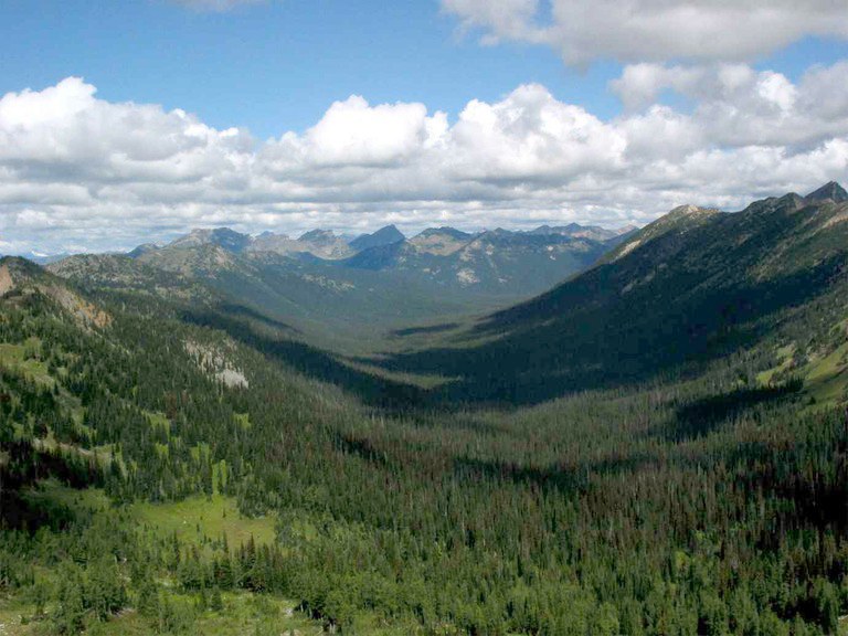
The West Fork Pasayten River trail is perfect for hikers seeking solitude or hoping to spot a moose. Follow the trail as it descends steeply from Slate Peak and meanders through alpine meadows.

Beginning from the trailhead near Slate Peak, hike north, enjoying broad views, including 7,855 foot Pasayten Peak and Gold Ridge to the east. The trail skirts the river, crossing multiple creeks along the way. After 8.8 miles, keep right at the junction to stay on the West Fork Pasayten Trail (472). There are several established campsites along the trail.

Continue another 7 miles to rejoin the West Fork Pasayten River. This is a popular pack trail, so stay alert and remember to yield to pack animals.

Once you arrive at the junction with Robinson Creek (478), you have many more miles of wandering at your disposal. Head north to the abandoned Pasayten Airstrip, east to Tatoosh Buttes, or hop onto Buckskin Ridge (498) and hike south back to Slate Peak. Keep in mind that the Buckskin Ridge trail, while gorgeous, is more difficult than the West Fork Pasayten River trail.

This trail is part of WTA's Lost Trails Campaign. Learn more about how we're saving lost trails across the state here.

Toilet Information

  • No toilet at trailhead

More information about toilets

WTA worked here in 2022, 2017, 2014, 2013, 2012 and 2011!

Hike Description Written by
Multiple authors contributed to this report, WTA Community

West Fork Pasayten River

Map & Directions

Trailhead
Co-ordinates: 48.7379, -120.6786 Open in Google Maps

Before You Go

Trail closed: Wildfire

See weather forecast

Parking Pass/Entry Fee

Northwest Forest Pass

WTA Pro Tip: Save a copy of our directions before you leave! App-based driving directions aren't always accurate and data connections may be unreliable as you drive to the trailhead.

Getting There

From Mazama on Hwy 20, follow the Lost River Road 7 miles and turn right to stay on NF-5400. Continue 10 miles and turn right to stay on NF-5400. In 2.3 miles, you’ll reach a green gate. Park here, and take the signed trail down the road past the gate.

More Hike Details

Trailhead

North Cascades > Pasayten

West Fork Pasayten River (#472)

Okanogan-Wenatchee National Forest, Methow Valley Ranger District

Guidebooks & Maps

USGS Topographic (7.5 min) Slate Peak

USGS Topographic (7.5 min) Pasayten Peak

USGS Topographic (7.5 min) Frosty Creek

Buy the Green Trails Pasayten Peak No. 18map

Buy the Green Trails Washington Pass No. 50 map

You can improve or add to this guidebook entry!

West Fork Pasayten River

19 Trip Reports

Hiked here recently?

Submit a trip report!
 
Trip Reports