Trip Report
Spade Lake, Peggy's Pond, Cathedral Rock, Deep Lake, Lake Vicente, Spinola Creek & Waptus Lake via Waptus River — Saturday, Sep. 5, 2015
 Snoqualmie Region > Salmon La Sac/Teanaway
Type of Hike
OvernightTrail Conditions
Obstacles on trail:Trees down across trail,
Muddy or wet trail,
Overgrown in places,
Mud/Rock slide or washout.
Road
Road recommended for high clearance onlyBugs
No bugsSnow
Intermittent snow - not hard to cross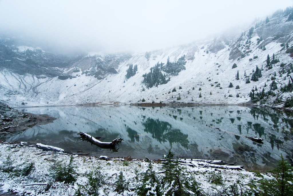
Squaw Lake, Peggy’s pond, Circle Lake, Venus Lake, Spade Lake, Waptus Lake, Deer Lake, Vicente Lake and Deep Lake.
It rains, it snows, it is windy and freezing cold again, which could mean only one thing – after the long and hot summer backpacking season is back!
This is one long (~30 miles) loop around the south side of Mount Daniel, highest crest peak in Alpine Lakes wilderness. Late July I walked another little 23 miles hike on the north slope of Daniel - https://www.facebook.com/kozhekin.nikita/posts/10152917539315741 Hyas Lake, Marmot Lake, Noname Lake, Jade Lake and liked them a lot. Just like Jade Lake, high alpine lakes on the south side of Daniel are filled with water from glacial melt, which gives them amazing blue color. There is also no trail for 5-6 miles of high alpine terrain to Circle and Venus lakes, which makes them a bit challenging to reach, but also one of the wildest and unspoiled jewels of the mountain.
Saturday morning me and the dog Cookie started around 10 am from the pothole ridden Cathedral pass trailhead. A few uneventful switchbacks up (despite the sign “wasp nest near second switchback, 8 stings per person”), we reached peaceful little Squaw lake, continued up to the Cathedral pass. Despite the clouds, we could see shiny blue of Deep Lake down below us. Instead of continuing down with PCT to the deep lake, we turned right on the Peggy’s pond trail. This little trail is already not for the faint of heart. It is deteriorating a lot and basically does not exist anymore in places, where one has to carefully walk the edge of Cathedral rock. Once we reached Peggy’s pond and a U-shape tarn official trail stops and cross-country travel begin. Because of the clouds we could not see much around us, so me and Cookie just started bushwhacking straight up the slope. It was pretty tough going and very steep and rocky in places, but we continued on grabbing to branches and roots. Luckily we didn’t get cliffed out and once reached 6200 feet found the nice straight boot path traversing the ridge to Circle lake. I assume it should be possible to find a better boot path up to it too, instead of going through the bushes like we did.
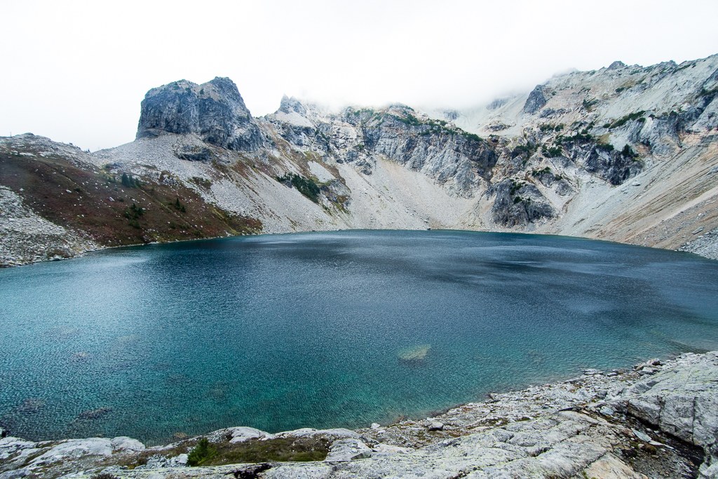
Now terrain is open and basically deserty. There is almost no vegetation, just rocks left by the recently retreated glaciers. Circle lake is blue and pretty, but not actually circle. This part of the trip was easy.
After circle lake things get tough again. It was very cloudy, below freezing and very-very windy. There is no boot path anymore, you basically have to walk the ridge between two lakes on scree. This scree is very nasty, wet from recent snow, very slippery, very loose and very-very steep. I hate going down straight on rock fall, but I hate traversing on the unstable scree even more. I was really freaking out in places, but Cookie did great and we managed to get up and down the lake, including going through a few feet of vertical chimney, where Cookie had to be lowered on the rope.
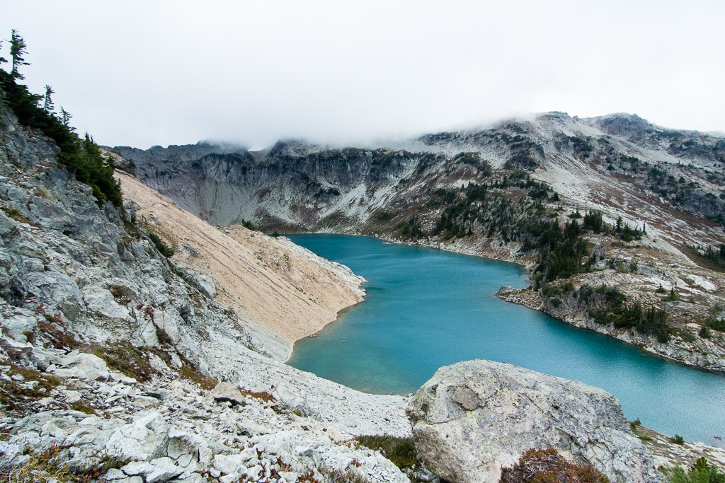
Finally, we got to lake Venus. And from Venus is straight down on glacier polished granite along the waterfall to a much more lovely and green Spade lake. Usually people stay at Venus or Circle Lake overnight, but it was still early and cold, and we had nothing to do, so we went down to Spade lake and then took official trail all the way down. Despite official status, Spade lake trail doesn’t seem to be maintained at all and is basically covered with tons and tons of blowdowns. It intersects with PCT at lower elevation, but instead of going to PCT we went even lower, to the low-low 3000 feet (even lower than the trailhead) huge Waptus lake and camped for the night at 7pm. I’m glad we did camp so low. It was raining and snowing heavily all night and Cookie curled into the smallest furry ball I’ve ever seen trying to keep warm. Also Waptus lake is pretty.
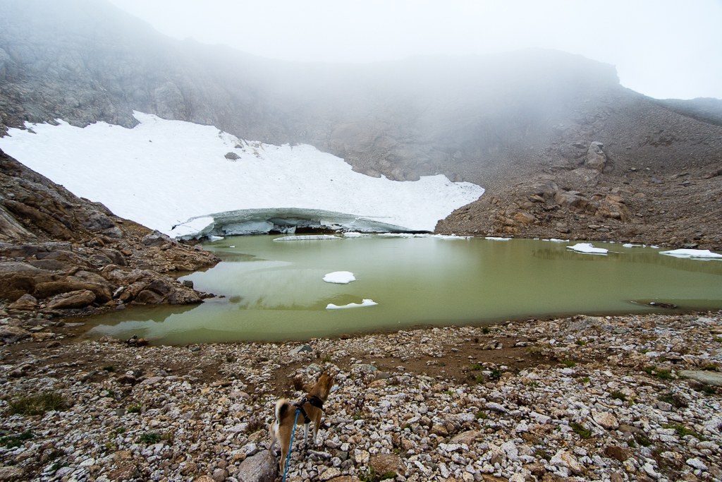
Next and very wet day we walked along the shore of Waptus lake to Spinola creek train, until it joined PCT again. PCT is very gradually going up, until it reaches Vicente Lake trail turnoff. Unfortunately by that point my GPS batteries died and I had no backup. Deer lakes looked nice and swampy and Vicente Lake trail was easy to follow until almost the very end. There some rock fall destroyed parts of the trail and with very bad visibility it was easy to get lost. We persevered through trial and error and finally got to the rock scramble across the creek to the lake. It was very steep, snowy and wet. A little hard with the dog, but we managed, both up and down.
From Vicente lake down again to PCT, and then to Deep lake. It is funny but we could see less of the Deep lake from the shore, than what we have seen of it from above the pass just the day before. Clouds now formed really thick and wet soup all around us. We went back to PCT, up the pass again and back to Cathedral pass trail. Back to the car at around 4pm.
https://connect.garmin.com/activity/891599271
https://connect.garmin.com/activity/891599273
Comments
here comes the Fall
Posted by:
seattlenativemike on Sep 08, 2015 02:58 PM
This was a pretty nifty way to access Spade Lake. Did you ever figure out where the trail was going from Peggy's Pond to Circle Lake? you said you did some bushwacking but then found a good straight boot path - ever find out where that started?
Posted by:
HermitThrush on Feb 18, 2017 02:59 PM
This was a pretty nifty way to access Spade Lake. Did you ever figure out where the trail was going from Peggy's Pond to Circle Lake? you said you did some bushwacking but then found a good straight boot path - ever find out where that started
Posted by:
HermitThrush on Feb 18, 2017 03:00 PM
Nope, never found that part of the trail, it is hard to see the trail there, because there is a lot of vegetation and a lot of boot trails all around, many ending nowhere. Once on the open ridge it is much easier to find the one boot path everyone is taking, because it is open.
Posted by:
Kitya on Feb 19, 2017 03:23 PM