
WOW! Talk about an adventure . . . I cut a wide swath through the Wenaha-Tucannon Wilderness over three nights/four days and somewhere in the neighborhood of 56 miles. Some parts of the trip were great, others were absolutely terrific, and others were simply maddening. None of it was boring and most of it was awesome. Here goes . . .
I started on the Panjab Creek Trail early afternoon on Friday, June 16th, and made the climb to Indian Corral in good time and in a light rain most of the way. There was some water on the trail due to drainage issues, but overall I found the trail to be in good shape and pleasant to hike. Perhaps a quarter-mile or so from where the trail hits the meadow is a well-used trail, complete with user-made sign ("Dusty Trail") that leads to a hunting camp ("Dusty Camp", again with a user-made sign).
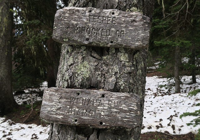
It was a bit tricky navigating from the meadow to the junction with Mount Misery Trail, but I eventually ended up at the (signed) junction with Crooked Creek Trail and headed over to Dunlap Spring to get some water. I then continued on Mount Misery Trail toward Diamond Peak and saw a beautiful cinnamon colored black bear in one of the meadows. Clover Spring and Bear Wallow Spring had signs and decent camping near Bear Wallow Spring, but I pushed on an ended up camping at a signless spring (and one unnamed on the USFS wilderness map) but that I've seen referred to other places as "Squaw Spring". This campsite appeared to be heavily used, but was conveniently located.
The next day I continued toward Diamond Peak intending to take the Melton Creek Trail down to Crooked Creek, to the Wenaha River, and to Fairview Bar to camp. A long day made even longer because I missed the junction and hiked all the way to the Diamond Peak Trailhead and had to backtrack. The junction is indistinct and was partially obscured by snow and, although signed, the sign is perfectly camouflaged. I didn't beat myself up over the mistake, figuring the extra 1.2 miles added to the hike were punishment enough. There was some snow in this stretch but nothing that was inconvenient.
I continued on the Melton Creek Trail and down its endless switchbacks, enjoying the nice views and wildflower patches. There were some blowdowns on the trail but nothing that really interfered with my pace, just allowed me to exercise some different muscle groups.
The crossing of Melton Creek was done without taking my boots off (or getting them wet) but at First Creek I did have to ford it, but it wasn't too big a deal.The lower stretch of Crooked Creek trail was rather overgrown, but the trail was still easily followed. The unbridged crossing of Crooked Creek on a log was a bit nerve-wracking but was convenient enough. The trail along the Wenaha River was in good shaped to Fairview Bar and appeared to have been recently worked on. The forest here ranged from having been badly burned to catastrophically burned and Fairview Bar was not an appealing place to camp, but it was where I laid myself to rest for the night after jumping in the river to cool down and rinse off.
The next morning I got an early start on the climb up to Smooth Ridge/Weller Butte. As seems to be the pattern in the Wenaha-Tucannon, the junction was indistinct but the trail was obvious as it headed up the open hillside. Some great views of the Wenaha Canyon made me stop in my tracks at the top.
Important warning here -- once the trail passes from the open slope into the recently burned forest, with dense and tall vegetation, it becomes exceedingly difficult to follow. I was impressed by just how quickly and completely the trail disappeared. I was able to follow stock tracks for a while, but then lost even those in the vegetation. I ended up getting way off the trail, totally turned around, and cut cross-country using map and compass and actually ended up on the Packer's Trail, which I used to connect with the trail to Smooth Ridge/Weller Butte. Embarrassing mistake, but one that was easily made, and I hope this trip report can help others from getting lost up there as well. Be prepared to use map and compass and take it slow up there . . . you will not be able to make "good time" from the top of the slope to the junction with Packer's Trail, at least in my experience.
From Packer's Trail junction on, the trail was distinct and absolutely delightful to hike. Wildflowers, views, birdsong . . . hard to beat! Twin Spring was a welcome respite and water refill after the rough morning.
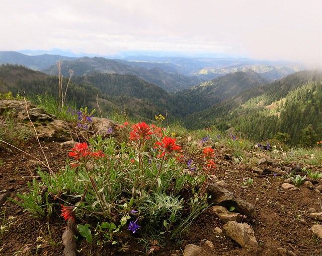
Weller Butte had some great wildflower displays and views and I continued on to Lodgepole Spring, where I got a bit turned around due to the hunting camps, side trails, game trails, etc. but I was able to backtrack, find the trail, and continue on (the trail stays lower in the woods than I expected) toward Oregon Butte, which was my destination for the night.
The sun was setting as I neared Oregon Butte and the last hour or so of hiking was pure bliss . . . beautiful sunset and views of the landscape and I made it Oregon Butte Lookout just as the stars were coming out. I had brought enough water from Rettkowski Spring to just bivy near the lookout and the stars were incredible. It was a clear, calm night and perfect for sleeping under the stars.
The sun came up early (too early for a tired hiker) and I packed up and headed out on Mount Misery Trail to Panjab Trail and out.
Few quick additional notes:
- Although there were two groups of hikers when I started on Friday, I didn't see them during my trip and only saw two other day hikers on Friday. When I arrived back at the trailhead on Monday, I saw two other groups coming out. During the middle days of my trip I saw no one.
- While there doesn't seem to be a huge amount of users, it seems that some of the groups that do camp here leave their mark pretty deeply with litter, building furniture, caching supplies, cutting wood, etc. Definitely seems like Leave No Trace hasn't been adopted by some of the groups yet. I suppose I'm guilty too though as I left behind a small notebook, bandana, and photocopied paper map and guidebook description when I fell in some deadfall while trying to regain the trail near Mud Spring and, unbeknownst to me, the bottom of my cargo pocket was ripped open and its contents disappeared into the vegetation.
- Wildflowers, wildflower and wide open spaces are the hallmarks of this trip and are nothing less than superlative in many places.
- Do not underestimate the density of vegetation and difficulty of following the trail from above Fairview Bar to the junction with Packer's Trail. I did and paid the price. Perhaps I missed a simple turn and things fell apart from their and better diligence could have prevented my misery, perhaps not. Regardless, this is not an area I would want to find myself unexpectedly benighted in. Maybe with warning other hikers will be better prepared to follow the faint trail -- I sure hope so!
- This trail, at this time of year, is absolutely spectacular. Go hike it soon or put it on your calendar for next year!

Comments
Luke Bakken on Panjab Trail, Mount Misery, Wenaha River Trail, Melton Creek Trail, Crooked Creek, Smooth Ridge
Thanks for the trip report!
Most of the LNT violations you saw are hunter's camps. If you find egregious examples and can note their location on GPS the Umatilla Forest Managers can use that information.
Posted by:
Luke Bakken on Jun 22, 2017 03:23 PM
BYOC on Panjab Trail, Mount Misery, Wenaha River Trail, Melton Creek Trail, Crooked Creek, Smooth Ridge
Great trip report. Thanks! My wife and I are planning on doing almost this exact loop this weekend. We're starting at TeePee. Going down to the Wenaha via Crooked Creek and back out via Weller Butte Trail.
I've never been on the Weller Butte trail, but I was expecting it to be "untamed". I'm not sure if you've ever been in the Blue Mountains before, but most of the Wenaha wilderness is not well maintained. It's very rare that you don't need to do at least some bushwacking on any overnight trip. I highly recommend using a GPS for anything other than day hikes out to the popular spots like Diamond Peak and Oregon Butte. The USFS map isn't that great and a lot of those trails don't even exist anymore. In some cases, they're really more just suggested routes...as in the case of the Weller Butte trail.
And unfortunately, the trash at established campsites is pretty common too. It's the hunters that pack in huge amounts of gear and provisions on horseback. It's a necessary evil, though. These trails get very little use from backpackers and without the hunters, there really wouldn't be any trails to use at all.
Posted by:
BYOC on Jun 29, 2017 03:24 PM
Froof_D_Poof on Panjab Trail, Mount Misery, Wenaha River Trail, Melton Creek Trail, Crooked Creek, Smooth Ridge
Thanks for the great adventure report Markweth! We don't see enough trip reports from the Blue mountains, but I guess the joy of seeing no humans for days on end in the wilderness makes up for that. :) My experiance heading up the smooth ridge was similar. I used a GPS to follow where the trail should have been between the climb up out of the Wenaha and the Jct with Packers Trail and found that it was completely lost in a handful of long stretches to the fire. Local folks I've talked to said that trail never has been more than an elk path.
Posted by:
Froof_D_Poof on Sep 28, 2017 01:08 PM