A Map In Your Pack Is Worth Two Left Behind
If you’ve read almost anything from WTA about getting outside you know we want you to be prepared when you go hiking. Have water and snacks, extra clothing and all the other 10 Essentials, including a map.
If you’ve read almost anything from WTA about getting outside you know we want you to be prepared when you go hiking. Have water and snacks, extra clothing and all the other 10 Essentials, including a map.

Maps (and knowing how to read them) are important when you're going hiking. Photo by Erika Haugen-Goodman.
But the map part can be tricky. While you can buy maps online from our partner Green Trails, or visit an outdoor store to get them, that takes time and pre-planning. For digital maps (and we suggest always carrying a paper backup), there are apps with good map resources, like Gaia GPS.
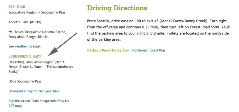
If you don’t have spare time to buy in person, or if you’re heading for the hills on a last-minute jaunt, WTA’s website has one more option to cover your bases, thanks to a recent addition to our Guidebooks & Maps section, found just to the left of the Driving Directions on each hike.

Plan Ahead
On many of Washington’s most popular trails, you’ll see links that take you to the corresponding Green Trails map, or to download a planning map that we've produced.
The Green Trails links go directly to the specific map of that area, making purchasing easy. I love Green Trails maps, and rely on them to orient myself in the backcountry. They are ground-truthed by hikers, and each one puts your hike in a larger context. You can use them to identify distant peaks, and the web of connecting trails on each one provides inspiration for future adventures. They are even waterproof versions.

Maps for Planning, or as a backup
If the price tag for a full map is more than you can spare, or if you’re heading out at the last minute, your alternate is WTA’s download link, which takes you to an 8.5x11 pdf file. This image shows the area immediately surrounding the trail you’re planning on hiking, as well as a highlighted track of the trail. You can print it out, or download it to your phone, so you can reference it even if you don’t have signal.
The tracks on those maps are ground-truthed by me and my team of volunteer hiking guide correspondents, who help me keep the Hiking Guide up to date. WTA produces the pdfs, creating them as the tracks come in, which is why not every single hike has a pdf map on it. Not yet, at least. Many of them do, though, including some local parks, and maps of those areas are useful when signage is poor.
 You can also often find useful maps of state parks and other smaller greenspaces at the kiosks, usually stationed at trailheads. Photo by Grady Olson.
Whether you’re a seasoned backpacker or just getting started hiking, we want you to be safe out there. And that means making it easier for you to have the resources you need for a safe and fun outing.
A map is no help if you don’t know how to read it. Find tips on getting started in our maps resource page.


Comments
A paper map never has a dead battery.
Posted by:
Olywa on Apr 27, 2021 06:57 PM