
Alpine Lookout is a classic central Washington ridge walk. The distance on this hike makes it a bit harder than moderate, but two-thirds of the climb is completed in the first two miles, and the rest of the way out follows the ups and downs along the ridge slowly climbing to the lookout.
There are great views south and east into the Enchantments. Occasional overlooks allow you to gaze down on Lake Wenatchee, across to Dirty Face lookout or north to Glacier Peak. Of course, there are great 360 degree view from the still occasionally staffed lookout.
There are good wildflowers in July and August and vivid fall colors in autumn. An added bonus is are the frequent mountain goat sightings near the lookout. Remember that mountain goats are wild animals -- stay well clear of them if they are hanging around, and never feed them.
This is a dry trail, with just one seasonal spring very close to the trailhead. Past after that, there is no water. Though in early spring you may pass traces of last winters snow, plan accordingly.
The hike starts out on the edge of an old logging area and quickly moves into forested old-growth as you hike steeply up to the ridge. Before arriving at the ridgeline, break out into an area that was heavily burned in the mid-1980s. Recovery is in full swing and soon the expansive views to the east will be obscured by lush forest cover.
In a little over a mile, reach the junction with the Nason Ridge trail. Here turn left, west. In a quarter of a mile the trail will come close to the north rim of Nason Ridge where there are excellent views down to Lake Wenatchee.
Nason Ridge is a multi-use trail. Horses are quite commonly spotted closer to the stables at Lake Wenatchee State park. In hiking this trail annually for ten years I have only encountered motorized trail bikes once, though they are more frequently found on the lower section of Nason Ridge Trail.
The trail continues for another three-quarters of a mile around the south side of aptly named Round Mountain. There is not a track to the top, and no need for one; it really should be named Round Hill, since the lower summit is forested across the top and there are no views. From here the trail will undulate up and down along the ridge. There are many open stretches filled with wildflowers and great views to the south.
At a bit over three miles from the junction watch for Nine-mile saddle. It is not hard to miss; the trail narrows to follow a ten-foot wide knife edge between steep, rock filled gullies that drop off to Highway 2 on the south and the Little Wentachee River drainage on the north. There is less protection to the north, and the view is stunning, so it is easy to miss the metal mileage marker “9” nailed to a tree on the south side of the trail.
If you're hiking with kids and you have a GPS, challenge them to find the other mileage markers on your return trip. I have found “8”, “7”, and “6” on the way back to the Round Mountain trail junction (but the GPS helped a lot). The markers are not always as easy as “9” was to spot, but all are pretty close to being one mile apart.
A few hundred yards beyond Nine-mile saddle, arrive at a trail junction where the Nason Ridge trail heads left, down to Merritt Lake. Merritt Lake provides an alternate route to Alpine Lookout, almost identical distance but more climbing as you start 600 feet lower. Stay right here. The lookout is up one last traverse, roughly 250 feet above this point and a bit more than one-half mile.
From the lookout, enjoy the views in all directions on a clear day. You can see Mounts Rainier and Stuart, Glacier and other peaks ranging up and down the Cascade crest. Alpine Lookout is the only remaining lookout structure in the Stevens Pass area, though many former lookout sites can be found in the immediate area.
WTA Pro Tip: For lookout-type views without the structures, you could also try hiking Rock Mountain, Dirty Face Peak, Poe Mountain, Mount David, or the harder to access Carne Mountain. All are excellent hikes. The most moderate is Poe via Irving Pass, the most challenging, Mount David.
Alpine Lookout

-
 Length
- 10.0 miles, roundtrip
-
 Elevation Gain
- 2,600 feet
-
 Highest Point
- 6,235 feet
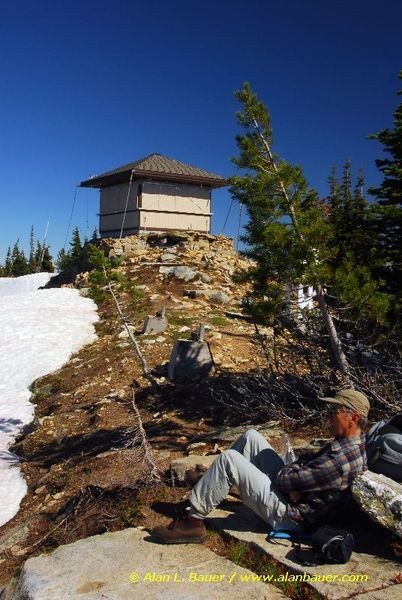
This is one of the most popular hikes along the US 2 corridor, and it's easy to understand why: a historic and active fire lookout, an enclave for mountain goats, miles of flower-blooming meadows, jaw-slacking views of Lake Wenatchee, Glacier Peak, and hundreds of other peaks. It's amazing there aren't more hikers sunning themselves on this Nason Ridge summit. And being on one of the area's first high peaks to shed its winter snows, Alpine Lookout makes for an excellent early summer adventure.
Continue reading
Parking Pass/Entry Fee
Northwest Forest PassHiking Alpine Lookout
Map & Directions
 Trailhead
Before You Go
Parking Pass/Entry Fee
Northwest Forest PassWTA Pro Tip: Save a copy of our directions before you leave! App-based driving directions aren't always accurate and data connections may be unreliable as you drive to the trailhead.
Getting There
On Highway 2 heading east, proceed to the junction of FR 6910, roughly 18 miles east from Stevens Pass. This junction is a quarter mile after the large rest stop. It is not signed well, so look carefully for where you can make a left turn. The turn off is on a slight curve, be watchful for approaching traffic.
On Highway 2 heading west from Leavenworth, proceed west to Coles Corner approximately 15 miles. Continue for another three-quarters of a mile. FR 6910 is on the right, as the road bends right. Look carefully for the turn, it is not signed well.
Once on FS 6910, in 0.2 miles you will cross a bridge over Nason Creek. In half a mile, you will cross under some power lines. 4.4 miles up this road, turn right on 6910.1. From here it is one quarter of a mile to the trailhead.


