

The Alpine Lakes Wilderness may be reached from numerous trail heads along the I-90 corridor. This little trail-gem sparkles, hidden in Snoqualmie Pass. It varies in terrain from abandoned logging road, through clear cut, all the way up to pristine alpine lake(s) nestled into a glacier scoured cirque. Seasonal changes make this medium difficulty hike worth returning to time and time again.
When you’ve left your car be certain to follow the directions on the sign: “Trailhead 100 Yards Up Road”. Walk those 100 yards, then take a spur road off to your left.
Formerly gated (the yellow posts indicate this), it's now simply a road. Walk up this road for a half-mile. The logging-road-turned-trail is fairly soul-less, though wildflowers flourish in the disturbed soils and the trees are gaining height. Magnificent blooms of beargrass are abundant here in late June and early July.
After a half mile on this second road, your route intersects with a narrow, winding trail. Look for a brown pole with a small sign featuring a hiking symbol and arrow pointing left. Start hiking up this true trail, through an old clearcut.
After 1.5 miles of hiking, find yourself in a clearing where there is a sign with arrows indicating the Lake Lillian and Margaret Lake trails. Since you're heading Twin Lakes and Lake Lillian, take the trail marked just for Lake Lillian.
From here, the trail descends to Twin Lakes over the course of a mile. Sandy bottomed and warm, this can be a perfect turn around point or meadow to luxuriate in. Stick with the most heavily trodden path bending off left of the lakes and cross the lake outlet/meadow.
If you're heading to Lake Lillian, the trail does a fair amount of up and down, rising, descending, and then rising steeply before reaching Lake Lillian. Along the way you will cross the toe of a sizable talus slope. Just as you get to the southern edge of the talus look for a waterfall cascading down Rocky Run to your left.
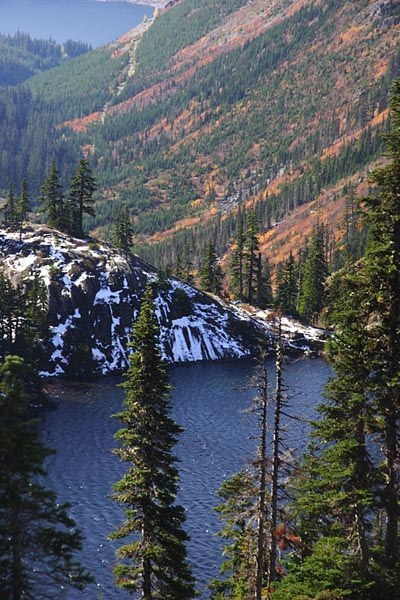
Lake Lillian will almost be a surprise when you pop over the ridge to it. The water is pristine, the granite and sparse hemlocks gorgeously framing this aquamarine paradise. The lake banks are steep so exploring can be difficult although a climbers track runs up the east side of the lake towards Rampart Ridge and beyond for the adventurous. Linger here at the lake for an hour or a day or two. You’ve only just crossed into the Alpine Lakes Wilderness.

 Trailhead


