
This hike has a little bit of everything.
To reach Little Joe Lake, hike Gold Creek Trail with gradual ups and downs to the Alaska Lake turnoff at about 5 miles. The main trail goes left and uphill to Alaska Lake. Take the other way.
The Joe Lake trail starts here and goes straight ahead into the open meadows of slide alder and vine maple. This is where the work begins as the trail is no longer maintained past this point. Follow this rough trail around Alaska Mountain paying careful attention to where the main trail is (survey tape in trees marks the way). You will have to duck, crawl, and plow your way through this tangle of brush and the occasional downed log. Watch your step as there are lots of rocks in the trail that will twist an ankle. It's a pretty tedious trek through here so slow down and take your time.
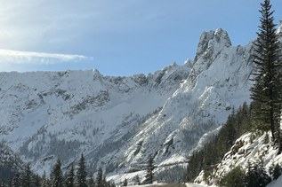
After about two miles, you will encounter a beautiful waterfall on your left. Once you cross the water you'll be on the right side the waterfall and the trail is no nonsense at this point. It goes straight up. You will not need hiking poles and coming back down almost guarantees removal of your pack and sliding it down in front of you with a rope.
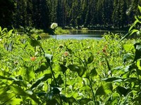
Once you have made it to the top, a plethora of campsites await you and if you are there in midsummer, squadrons of mosquitoes. Aside from the lake and meadows surrounding the lake, there are also several small ponds surrounding the lake.
-Side trip 1, at the Alaska Lake trail, there is an abandoned gold mine about 500' above the valley bottom. Look for it to the right of the Alaska Lake Trail. You can only see it from the bottom of the hill. Take a good look at where it is and then look for a faint trail that leads that direction off the Alaska Lake Trail. The mine has about 6" of water in it during the summer and can be explored without flashlights.
-Side trip 2, once at Joe Lake, the crest trail is a few hundred feet above the lake, the short route up is at the opposite end of the lake through the trees, but the no nonsense route up is right up the steep meadow or chute at the base of Huckleberry mountain. To the North of the lake on the PCT, there are numerous meadows and ponds to explore. Views are pretty good too.
Joe Lake

-
 Length
- 16.0 miles, roundtrip
-
 Elevation Gain
- 2,235 feet
-
 Highest Point
- 4,625 feet
This hike has a little bit of everything (trout-filled lake, views, forest, flowers) and surprisingly a good dose of solitude.
Continue reading
Hiking Joe Lake
Joe Lake
Map & Directions
 Trailhead
Before You Go
Parking Pass/Entry Fee
Northwest Forest PassWTA Pro Tip: Save a copy of our directions before you leave! App-based driving directions aren't always accurate and data connections may be unreliable as you drive to the trailhead.