The ridge is a gently rolling basalt plateau, running for 50 miles in an east-west direction between Ellensburg and Yakima, notable for cliffs and talus slopes at its perimeter, with elevation varying from 3800 to 6300 feet. The Forest Service’s Wilderness Evaluation from 2009 states, “[t]here are no major scenic values.… The key area attraction is the motorized trail system.” However, you may come to a different conclusion after visiting this amazing area! The northwest segment of Manastash Ridge covers 16.7 miles of rugged terrain from Quartz Mountain to Blowout Mountain, with Mount Clifty near the midpoint. Hiking options include an end-to-end traverse or covering a single segment, but come prepared to camp or bring adequate essentials for the mileage you will undertake.
From the trailhead parking lot near the summit of Quartz Mountain, descend a dirt path to where trail #1388 starts. Be prepared to share the gravelly and rocky trail with occasional motor bikers. The journey commences with jaw-dropping views of the Little Naches River valley and Mount Rainier to the Southwest. The trail runs west-northwest from Quartz, meandering over the ridgeline, with clear views of Mount Stuart to the northeast.
There are junctions with options for “most difficult” or “easy.” The “easy” versions involve relatively long diversions to trail junctions that add about 0.5 miles to the journey, so stick with the “difficult” segments which are not that much more difficult and shorten the journey.
At 1.1 miles, go straight at Little Naches Road. The trail zig-zags into and out of forest cover intermittently, with ridgeline views of nearby mountains. 2.1 miles into the hike, pass by rocky outcrops and peekaboo views of Mount Rainier to the southwest.
At 3 miles you reach Panther Ridge, approximately the midway point between Quartz and Mount Clifty. Continue 4.5 more miles to Clifty (summit elevation 6245 feet), where the trail drops and follows the countours of the mountain’s cliffs.
If you have come equipped for the full traverse, 9.2 more miles to Blowout Mountain, you will cross 3 recently built roads along the way. At Blowout, the trail contours on a bench on the north side of the mountain before its final junction, with the Blowout Mountain Trail.
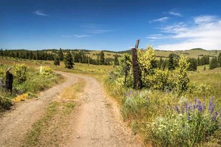
Along the way, you may see chipmunks, swallowtails, and red admirals. Wildflowers that bloom on this trail include arnica, lupine, paintbrush, Queen Anne’s lace, thistle, asters, and penstemon. Forest cover includes mountain hemlock, Douglas fir, larches, Engelmann spruce, subalpine fir, and western white pine. In some sections, the trail is steep and rugged. There are no water sources.
 Trailhead