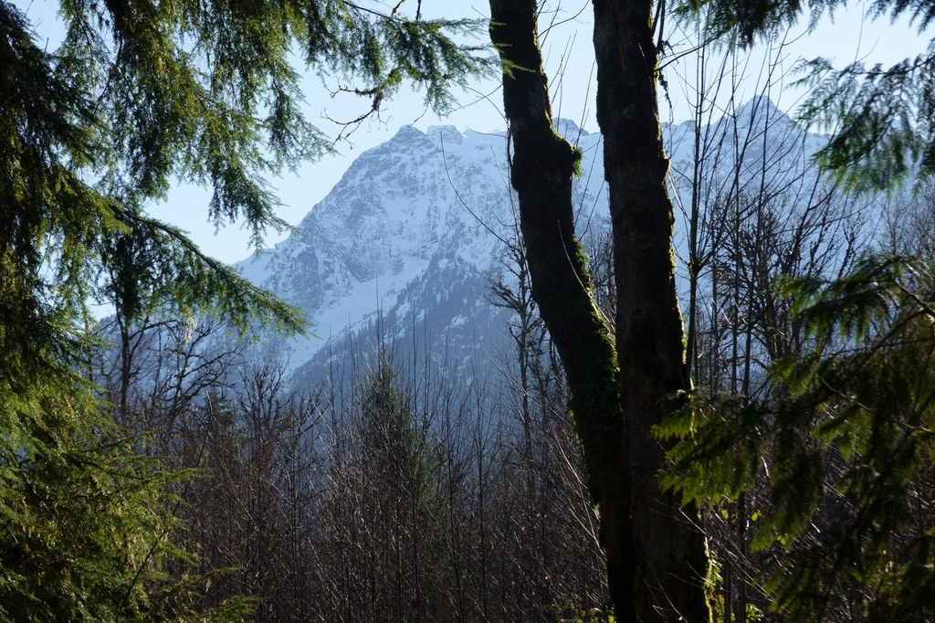
Whitehorse Trail - Swede Heaven to DaringtonRecent Trip Reports
Hiked here recently?
Submit a trip report!
There are
5
trip reports for this hike.
Day hike
Features:
Wildflowers blooming
Issues:
Blowdowns | Water on trail
Expand report text
Hide report text
Read full report
with photos
Once again, we lucked out with a mostly dry day! With all the rain we have been having, I am overjoy...
Once again, we lucked out with a mostly dry day! With all the rain we have been having, I am overjoyed when it stays dry long enough to get out and walk or hike! The Whitehorse Rail-Trail is 27 miles long, but only 6 miles are currently open. Snohomish County will be working on some safety issues with bridges, trestles and SR 530 crossings and hope in the future to open the rest of the trail.
The first time we went on this trail, I had trouble finding clear directions.....so here is my version: Take I-5 North to exit 208 (SR 530) and head towards Arlington/Darrington. Follow 530 through Arlington as if you are going to Darrington. Turn left at Swede Heaven Rd. The trailhead is about 1/2 to 3/4 of a mile down Swede Heaven Rd on the right. There is only enough parking for 2-4 cars at the trailhead so parking on the corner of SR 530 and Swede Heaven Rd and walking to the trailhead is the other option. On the SE corner of SR 530 and Swede Heaven Rd is the Whitehorse Shell and Food Mart....this is a good place to pick up a snack, get gas or use the restroom before or after the hike. There was no elevation gain in the 3 miles or so that we walked. It is a nice dirt and gravel trail. There were a few wet/muddy spots, but they were easy to walk around. A great trail for small children and would also be a lot of fun to ride bikes on. We ate our lunch on one of the bridges. They have nice wooden sides that make nice benches, as well as a good view of the water (which was running a lot higher than in the fall when we went). We were the only people on the trail today....aside from the resident dogs that seem to be a permanent fixture on the trail. They hung around and waited for us to finish lunch and then came and cleaned up the crumbs when we left. One dog named Gracie followed us for most of the trail - and would not stop. She is a golden retriever and very sweet, but followed us all the way out to SR 530 and we were worried she was going to get hit. She had tags on and we called her owner and he came and picked her up. For my full trip report and photos check out my blog post: http://ahomeschoolmomshikin[…]/whitehorse-rail-trail.html
Whitehorse Rail-trail
— Oct 06, 2010
— mburger718
Day hike
Features:
Fall foliage
Expand report text
Hide report text
Read full report
This was a nice, easy hike with lots of leaves on the ground and color on the trees. There are bridg...
This was a nice, easy hike with lots of leaves on the ground and color on the trees. There are bridges along the way that have wood edges that make nice benches to eat lunch or rest on.
We started out on Swede Heaven Rd. and walked about 1/2 mile North (If you decide to walk, keep a close eye on children, as there is a fair amount of traffic on Swede Heaven Rd.) to the signed trailhead. There is room to park on the corner of Swede Heaven Rd. and SR 530 and that is where we parked. There is room for a vehicle or two at the trailhead as well. We walked about 2 miles in and then turned around and walked back. We did encounter several wet, friendly dogs that accompanied us on most of our walk. We had children with us ranging from 2 to 12 years old and everyone enjoyed themselves. The kids enjoyed walking down to the river and kicking the leaves on the ground! Day hike
Features:
Fall foliage
Expand report text
Hide report text
Read full report
with photos
I had a great time wandering around the Darrington/Oso area today.
First order of business: The ...
I had a great time wandering around the Darrington/Oso area today.
First order of business: The Oso General Store is open for business! Please visit this fine store when you can - help keep this business thrive! They have lots of convenience store items, as well as an espresso window (open at 5 AM!), and a very NICE wine selection. The Whitehorse Rail trail is accessible in many places. After wandering various little access places along the Stilly (saw some eagles), I chose to visit the beaver ponds on the Whitehorse Trail a little beyond Trafton (which is 3 miles outside of Arlington). From Arlington, pass the Chevron in Trafton (Chevron is on the left), and continue a few miles to a little beyond the truss bridge at Monty Road. Look to your right, and turn down a road and park at one of the many little access points to the Whitehorse Trail. If you see a sea of dead snags along the right side of Hwy 530, you've gone too far. Turn around and take the first road you come to - the access is close to the sea of snags. The beaver ponds are a mere few minutes walk, and very pretty with reflections. I wandered about a mile or so beyond the ponds before returning to the truck. You can go much farther than a mile; but I was wearing sandals, and stopped to visit the beaver ponds on a whim. This is a nice, quiet, and pretty little rail trail. Day hike
Expand report text
Hide report text
Read full report
with photos
Snohomish County's Whitehorse Trail is a new rails-to-trails project that will eventually connect Ar...
Snohomish County's Whitehorse Trail is a new rails-to-trails project that will eventually connect Arlington and Darrington. Most of the trail is not technically open to the public, but gets quite a bit of hiker use anyway.
The 6 mile section of the trail between Swede Heaven Road and Darrington is one of the areas open for use now, and it is a good one. We walked the trail a couple miles from Swede Heaven Road (love that name) to the bluegrass festival grounds. The countryside is still very rural here; the vistas are mostly of forest. The trail approaches the N. Fork Stillaguamish several times and we greatly enjoyed climbing down to one of the fine riverside beaches and lazing in the warm sun. Here and there, we got great views of the awesome north face of Whitehorse Mountain, still draped with deep snow. Even on this spectacular Sunday, few users were to be seen. Perhaps there are too few legitimate users: with no enforcement and no one around to complain, one section of the trail has been illegally used as a shortcut for dirt bikes and ATVs. The Whitehorse Trail is a fine choice for hikers looking for an easy, low-elevation hike in the Darrington/Arlington area. Day hike
Expand report text
Hide report text
Read full report
with photos
Snohomish County has brushed and worked on parts of the portion of the old railroad grade that ran f...
Snohomish County has brushed and worked on parts of the portion of the old railroad grade that ran from Arlington to Darrington.
Friday I met a freind at Swede Heaven Road on Hwy 530. We then stashed my truck at the Darrington Ranger station and went back to Swede Heaven to begin our 6 mile rail-trail walk to Darrington. We walked on Swede Heaven Road a few minutes and picked up the rail-trail. It's still covered with a couple inches of hard-packed snow, but with Craig in tennis shoes and me in summer hiking boots, it was no problem. The trail is wide and free of brush. If it encroaches in summer, it's blackberry and no fun, but this portion is typically well-maintained, being so close to town. A bridge over pretty Squire Creek is very nice, as are the many wonderful views of the Stillaguamish river, peek-a-boo views of Round Mtn and Higgins, and an in-your-face views of Prairie Mountain and Whitehorse. This trail ends at Price Street, in the Forest Service Compound (but only a couple buildings belong to the FS nowadays). Sunday I joined freinds in Trafton to walk another portion of this trail. Trafton is at the Chevron station on Hwy 530 3 miles beyond the Jordan Road traffic light in Arlington. This portion of the trail is accessed from 115th Avenue a bit west of the Chevron. Drive this pretty road to the end, where there is a small parking lot at a farm that Snohomish County now owns (I'm hoping they'll make it a park museum!). There is no snow on this portion of the trail, and is very recently brushed and cleared, and some new gravel put down as well. Walk west on the trail, through old farmland, and to a big railroad bridge over the river. This bridge has new decking suitable for feet. Hold onto the kiddies, though; it's a train bridge and there are no railings. This is a very pretty walk along the river, and skirts some nice wetlands at about 2 miles from the trailhead. We saw a couple of eagles and bobcat tracks. You can go farther, but the trail ends at a railroad trestle in Arlington that is closed to the public. It's big, tall, and not suitable for young'uns to walk on (railroad ties, not decking for feet). An excellent way to spend a day. A rail trail is always great for a rainy day, and when it's sunny, the trail is wide enough to let sun shine on your face. To sum it up: Access one portion on Swede Heaven off Hwy 530. Access another portion west of the Chevron at Trafton on 115th Ave. |
Map it
|
Document Actions
- Email this page
- Print this
- Share


