

The Danville-Georgetown Open Space (DGOS) covers 340 acres just east of Maple Valley Town Square. It can be used in conjunction with several other natural areas. It is surrounded by Big Bend and Landsburg Reach Natural Area, Rock Creek Natural Area, Wetland 79 Natural Area and BN Peninsula Natural Area. Former logging roads form the backbone of the high-quality multi-use trails here. The area is named after the historic railroad line that once traversed the site and the former mining town named Georgetown.
The DGOS is a great starting place to enter into any of these other natural areas, but take care to stay on the trails, as to avoid trespassing on private property. There is also a privately-owned working forest nearby.
The area is filled mainly with second-growth Douglas Fir forest that is undergoing ongoing rehab by King County. They are working on reintroducing several native tree species. These areas serve as an active model of forest management that strives to balance ecological, economic and recreational values.
The trails here are well-maintained, often intersecting and crisscrossing other trails. Signage is available at some trail intersections, but it is somewhat unpredictable and can be misleading. Still, there are plenty of hike options here.
Putnam to Ridge Loop
One option in this trail network is a loop encompassing parts of Putnam Loop to the north and the Ridge Loop to the south. This route is what the mileage and elevation gain in this writeup refer to. A kiosk at the main trailhead contains a map and other resources. Taking a photo of the map (or bringing a paper copy) is advisable, because mobile data coverage in the area can be spotty.
If you are interested in bringing a large organized group (more than 12) or hosting an event, you must email the Regional Scheduling Officer or call: 206-477-6150. You can also text “KING DANVILLE” to 468311 for a downloadable map.
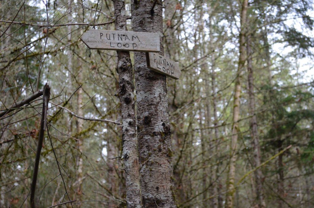
Start off along the trail on the north side of the road and after 0.1 miles, take a right at the sign marked Coyote, which you can follow for another tenth of a mile before taking a right at the marked trail for Putnam Loop.
This trail winds Northeast through placid forest behind the Summit Creek. After about 0.4 miles, take the center trail just past a white post labeled “Water” to stay in the Danville-Georgetown Open Space; turning left down the hill takes you toward additional trails in the Rock Creek Natural Area. A right will lead you to a dead end that is close to the nearby middle school.
Follow this trail for another half-mile before taking a right to stay on Putnam Loop, and then a left at the next fork in 0.1 miles to avoid a trail that leads to the middle school. After 0.3 miles the trail crosses Summit Landsberg Road; jog slightly to the right to find the new trailhead across the road. Turn right at the first fork, as the trail meets a more recently logged area that’s bursting with new growth. Follow this unsigned trail about 0.2 miles until you reach a large access road.
Turn left at the access road to walk uphill on the road for a few hundred feet, until you see the sign for Ridge Loop on your right. Ridge loop winds gently uphill with no steep sections, but beware of a potentially tricky stream crossing after 0.4 miles. Shortly after the stream, take a right at a logging road to stay on Ridge Loop. After 0.1 miles, take a right at the signed 3 Elk trail to head back toward the trailhead.
Extending your hike
A left here will take you deeper into the network of trails at the south end of the DGOS. You will soon see the road through the vegetation, but follow the trail when it turns right. In a few hundred feet you’ll arrive at a crosswalk that leads directly back to the trailhead where you started.
South Loops
Another area hikers can explore is the southern half of the Danville-Georgetown Open Space. It is especially popular with equestrians, so be aware of horses (and their droppings) as you navigate this crisscrossing network of trails. These trails don’t offer any particularly steep climbs or drops, but muddy trail conditions are prevalent in the lower points as the trails roll up and down the hillside.
From the kiosk at the trailhead, take the crosswalk to the south side of SE Summit Landsburg Road and follow the trail as it immediately jogs right. You’ll find yourself on a stretch of 3 Elk Trail, a broad gravel trail that runs the breadth of the southern side of the Danville-Georgetown Open Space.
After a quarter mile, turn right to join the Ridge Loop, which winds uphill through dense forest. After 0.2 miles, you can turn right to take a small section of the Lone Wolf Trail, which rejoins the Ridge Loop after another 0.2 miles.
After about half a mile, Ridge Loop crosses into private land. This is apparent on the King County Parks map, but there’s no marking along the trail itself. If you decide to continue, you’ll see several marked trails branch off of Ridge Loop into other areas of the private land.
The most direct route back to the Danville-Georgetown Open Space is to turn left when you see the sign for another section of Lone Wolf Trail, about a mile after the previous intersection of Ridge Loop and Lone Wolf.
You’ll know you’re back in the park when Lone Wolf crosses 3 Elk Trail. At this point, you can cruise on 3 Elk all the way back to the trailhead, or continue on Lone Wolf for a more strenuous hike through undulating forest. After 0.4 miles, Lone Wolf meets 3 Elk again, and at this point you can take a right onto 3 Elk for an easy half-mile back to the trailhead.
Usage notes
The DGOS is managed by King County Parks and is stewarded by Back Country Horsemen and is open to all non-motorized vehicles. The trails appear heavily used by horses in particular, the trailhead even includes a box for mounting a horse and a hitching post.
In spring the area can be quite muddy and would definitely require shoes that you don’t mind being both wet and dirty. The southern parts of the trails also include several crossings of a small creek that does not require extra equipment, but does require care and patience. If you would like to bring a canine companion, they must remain on their leash and be cleaned up after.
DGOS is available for day use only.
local history
The Danville-Georgetown Open Space and surrounding natural area’s trails are largely repurposed former logging roads. The area is named after the historic railroad line that once traversed the site and the former mining town named Georgetown.

 Trailhead


