

Take a rugged trek through creek canyons, down a four-wheeling road, over a remote pass, and back down through a multi-use trail to complete a challenging loop hike. You may have equestrians, mountain bikers, and ORV users for company, but any type of user can appreciate the views you’ll get along the way.
From the De Roux trailhead, hop on the Boulder - De Roux trail and enjoy the hike alongside De Roux Creek. The trail starts out flat, crossing a large, sturdy bridge and wandering alongside the creek, but soon begins to climb.
Continue 1.3 miles before arriving at a junction. To the left is signed “De Roux Spur 1392.1”. This trail leads to Koppen Mountain, and offers a slightly more direct way to the continuation of the Boulder-De Roux trail, which connects, appropriately, De Roux Creek to further west Boulder Creek.
But your way is the right hand trail, signed for “Gallagher Head Lake”. It’s a mile and a half of steady climbing here, as you go from 4080 feet to 5520 feet. Climb through the signature forest of the Teanaway alongside De Roux Creek as it becomes ever more dramatic, complete with crashing rapids and waterfalls. Top out at a creek crossing that takes some balance (or at least a set of trekking poles) to make it across dry.
From here, it’s relatively smooth sailing through a gorgeous river valley, complete with three established campsites with creek access. Please use the currently existing ones and do not create new sites. After three-quarters of a mile of meadow wandering the trail gets back down to business, beginning to climb away from the creek. One major switchback, and you’re at Gallagher Head Lake.
Expect company here. The lake is also accessible via an ORV road and a couple of campsites make it one of the only places ORVers can enjoy the beauty of the Teanaway. You’ll also be using the ORV road for the next couple of miles, so be careful on the descent and share the road.
From the viewpoint at the lake, cross a bridge recently replaced by the 509s, a club based out of Ellensburg. Hike around the west side of the lake, rhen begin descending, gently at first, but soon quite steeply, on the rutted road. At a large “Y” in the road, take the right-hand lane (straight ahead) and curve around to cross South Fork Fortune Creek You’ll cross back in just a few hundred more feet, and then the road begins to moderate its steep descent.
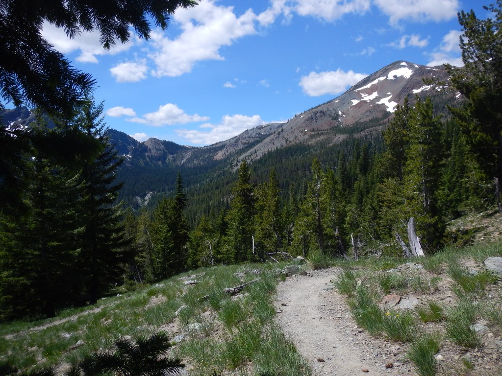
Be on the lookout for a trail branching off to the right. A downed tree curves along the road, but as you approach it, the trail is quite evident. Step onto this trail, and immediately begin regaining the 600 feet you’ve just lost from the lake.
While some maps indicate that this trail is more of a route, it’s fairly easy to follow. But it’s steep, and you’ll likely need breaks. Take them, and take in the stupendous views. Hawkins Mountain looms across the valley from you, and the snowy shoulders of The Cradle are further in the distance.
Topping out in the saddle, enjoy your first grand views of the Esmeralda Peaks and the craggy ridgeline that hides Lake Ingalls area. Begin descending, following large cairns. If there are none, just head downhill straight from where you came out – the trail becomes evident soon enough.
In less than a quarter mile, arrive at a junction. Left takes you to Lake Ann, straight ahead is your path. Now it’s 2.7 miles down into Esmeralda Basin. In spring, wildflowers are rampant here. Take advantage of the many creek crossings to refill your water bottle as needed. It may be all downhill from here, but it’s still quite exposed, and hot midday.
Nearly all of this loop is open to mountain bikers, equestrians, and hikers, so be sure to share the trail and know who has right of way. At one point, about 1.75 miles from the junction with the trail to Lake Ann, arrive at a Y junction. Take the left-hand trail and immediately cross a small creek, staying on the north side of the Basin.
Continue heading steadily down, trading wildflowers for evergreen trees, as you near a large creek. This is the headwaters of the North Fork Teanaway River. At the junction for Ingalls Way trail, there’s another good water access to refill, if necessary. You still have 1.7 miles to the end.
From the Ingalls Way junction, expect plenty of company. Lake Ingalls is one of the most popular hikes in the state, and plenty of people will be on trail heading that way. Do note that while this trail is multi-user, Ingalls Way is hiker-only. Luckily, the trail is quite wide for the rest of the way, and you only have 0.3 miles left to the Esmeralda Trailhead.
However, to reach your car, you’ll need to walk the road, (or follow a somewhat narrow, brushy route maintained primarily for horses) for a further 1.4 miles. This will spit you out right at the De Roux Campground, right where you started.
 Trailhead


