
Along with the numerous other I-90 hikes there is no shortage of ‘workout’ on this hike. Like its counterparts, this trail is largely for those interested in heading up, steeply. Moderated with switchbacks at times, and with a gradual traverse when you need it, the rewards here are not without effort. The actual summit is a rock-scramble, but the views and the flower-packed west facing slope near the top can be enjoyed without making the true top. More than a few remaining old-growth trees and a soft tread make this a well-rounded hike whether it is a training hike or your weekend reward.
Despite heavy logging, road building, and the old Chicago/Milwaukee railroad grade, which was decommissioned in the sixties, this trail maintains a lush character with numerous old-growth trees. The first few miles crosses power lines, the Iron Horse Trail, and Forest Service road 9020. Stick with it and power up the at-times steep trail. Peek-a-boo views of the Alice Valley and Mount Kent to the east will keep you interested.
At roughly 2.5 miles into the hike one needs to exercise caution around a series of avalanche chutes and snow bridges which can be undermined by flowing water. These snow runnels can be quite dangerous and hard-packed with snow. At this elevation, snow frequently lasts until early July so be cautious and realistic with your abilities and equipment. If there is snow, come back when it is gone, since on these steep slopes, snow can slide at any time. The trail continues to about 4 miles, where it turns west and then quickly north towards the summit ridge.
This last mile of the hike has small meadows, a vernal pond, and scrambly little rocky sections of trail. Although most will be satisfied with the views from this area, the true summit may beckon to others. Those who venture up should keep in mind: rain can make the rock slippery and although technically easy the scramble to the summit is very exposed. Watch for the steps and hand holds blasted into the ridgeline.
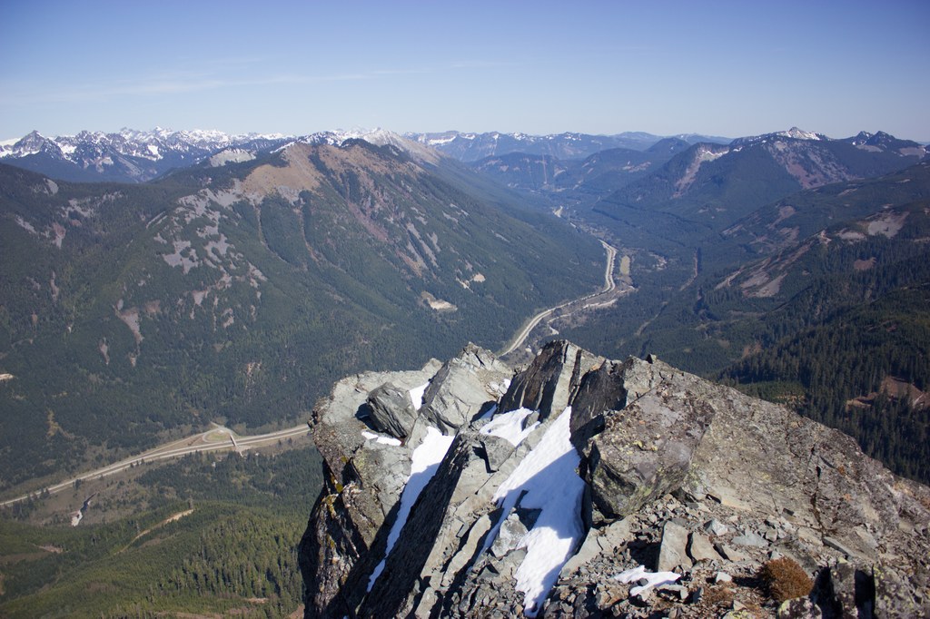
Views from the top encompass the full range of I-90 peaks, Snoqualmie Pass, and much of the Alpine Lake Wilderness. As you carefully descend the rocky summit, think of the pioneers who first documented these lands. General George B McClellan visited this area in 1853 surveying (unsuccessfully) for a route for rail lines to pass through the Cascades. He chose the never-used Yakima Pass. The more popular route was Snoqualmie Pass, home now to the major interstate highway you used to get to the trailhead.
McClellan Butte

-
 Length
- 10.5 miles, roundtrip
-
 Elevation Gain
- 4,073 feet
-
 Highest Point
- 5,162 feet
Parking Pass/Entry Fee
Northwest Forest Pass
Along with the numerous other I-90 hikes there is no shortage of ‘workout’ on this hike. Like its counterparts, this trail is largely for those interested in heading up, steeply. Moderated with switchbacks at times, and with a gradual traverse when you need it, the rewards here are not without effort. The actual summit is a rock-scramble, but the views and the flower-packed west facing slope near the top can be enjoyed without making the true top. More than a few remaining old-growth trees and a soft tread make this a well-rounded hike whether it is a training hike or your weekend reward.
Continue reading
Hiking McClellan Butte

WTA worked here in 2024, 2020, 2017, 2016 and 2014!
Map & Directions
 Trailhead
Before You Go
Parking Pass/Entry Fee
Northwest Forest PassWTA Pro Tip: Save a copy of our directions before you leave! App-based driving directions aren't always accurate and data connections may be unreliable as you drive to the trailhead.
Getting There
The main McClellan parking lot is on the south side of I-90 at the West Tinkham Road, Exit 42. Turn right at the stop sign at the end of the ramp. Pass the Department of Transportation facility and continue a hundred yards or so. Turn right into the parking area. Directions to the alternate parking area on the primitive logging road is for the intrepid to find on their own.


