
The 0.7-mile interpretive trail from the upper falls viewpoints to the lower falls viewpoint is family- and pet-friendly, good for beginners, teaches the basics of the flora and fauna near Snoqualmie Pass, informs about local Native American culture, and ends with impressive views of a Washington icon.
From the railed Falls Viewpoint, head down the walkway and make a right turn, and then a left, leading you behind the gift shop and visitor center. You will come to a kiosk with a map. The broad, gravel trail is just across the access road from the kiosk. As you descend approximately 250 feet over 0.4 miles, take a look at interpretive plaques introducing the native wildlife and provide their Snoqualmie names. Ferns, salmonberry, vine maple, alder, bigleaf maple, western hemlock, Douglas fir, and western redcedar are the major flora here, and they put on a flashy display of color in the fall. This section is a steep, providing a short challenge on the way back up. It is an excellent introduction to the region for novice hikers.
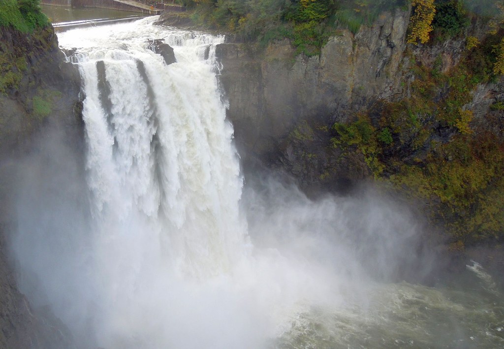
At the bottom of the hill, the trail passes by a lower parking lot and then follows a boardwalk along the river. Take in the sound of the waters crashing as you walk the final flat 0.3 miles to a viewpoint of the river curtaining down in a cloud of spray. Read the signs that chronicle the falls’ historical and cultural significance.
The Snoqualmie Tribe consider the falls to be humanity’s place of origin. The indigenous peoples of this region came, and continue to come, to this sacred place for restoration and reflection.The Snoqualmie Tribe continues to be an active steward of this place and asks you to be mindful when visiting. Since 1898 the Snoqualmie River’s 268-foot drop has been used to generate electricity, now the site is now managed by Puget Sound Energy. In the early 90s, Snoqualmie Falls became a cult icon when it featured prominently in the credit sequence to David Lynch's television series "Twin Peaks". The success of the show turned the falls into a local landmark that draws 1.5 million visitors per year.
Though you may be tempted to get closer to the famed falls, please don’t climb over the gate or railings to the river below, as the surfaces are often slippery, and river levels may change unpredictably.
WTA Pro Tip: After your hike, continue east on SR-202 for 1 mile for a visit to historic Snoqualmie, with its boutique shops, small restaurants, and train museum.
Snoqualmie Falls

-
 Length
- 1.4 miles, roundtrip
-
 Elevation Gain
- 250 feet
-
 Highest Point
- 450 feet
The 0.7-mile interpretive trail from the upper falls viewpoints to the lower falls viewpoint is family- and pet-friendly, good for beginners, teaches the basics of the flora and fauna near Snoqualmie Pass, informs about local Native American culture, and ends with impressive views of a Washington icon.
Continue reading
Hiking Snoqualmie Falls
Map & Directions
 Trailhead
Before You Go
The main parking area at Snoqualmie Falls is a paid lot. There are free parking areas available in the upper and lower lot.
WTA Pro Tip: Save a copy of our directions before you leave! App-based driving directions aren't always accurate and data connections may be unreliable as you drive to the trailhead.
Getting There
From Seattle, head east on I-90 to exit 22 for Preston. Cross over the freeway and turn right onto SE Highpoint Way/Preston Fall City Road. Continue 1.5 miles, coming to a traffic circle after crossing the Snoqualmie River. Turn right at the circle onto SR-202 East, continuing 4.0 miles until you reach the parking area on the right side of the road. There is room here for about 50 cars.
There are restrooms and a gift shop near the parking area.
take transit
This trailhead is accessible by bus! Plan your visit by bus using TOTAGO.


