Trails for everyone, forever

Home Go Hiking Hiking Guide Stirrup Lake
link

Stirrup Lake

Snoqualmie Region > Salmon La Sac/Teanaway
47.3045, -121.4036 Map & Directions
Length
2.4 miles, roundtrip
Elevation Gain
476 feet
Highest Point
3,586 feet
Calculated Difficulty About Calculated Difficulty
Easy/Moderate
  • Wildflowers/Meadows
  • Mountain views
  • Wildlife
  • Dogs allowed on leash
  • Lakes
  • Fall foliage

Parking Pass/Entry Fee

Northwest Forest Pass

The trail to Stirrup Lake is a road less traveled and a moderate hike through second-growth forest to a serene alpine lake tucked between Big Muffin and Meadow Mountain, paying tremendous dividends for lovers of huckleberries, wildflowers, and riparian fauna. Continue reading

Rating
3.88 out of 5

(8 votes) Log in to rate

Hiking Stirrup Lake

There remain a select few cirques of serenity, alpine lakes that are relatively unvisited. Stirrup Lake numbers among those riparian oases, its flora and fauna shielded by a location east of Snoqualmie Pass and a network of sporadically signed National Forest roads. Stirrup Lake rests in a saddle between Meadow Mountain and Big Muffin. If you wish to reach the shores of Stirrup Lake, pay close attention to the directions, as not all roads in this region have clear signage.

From the trailhead, walk west-southwest. Ground cover includes thimbleberry, salmonberry, devil’s club, deer ferns, and huckleberry—did I mention huckleberry? You will be wading through those bearers of ripe fruit in the late summer months, as they attempt to overgrow the trail. Overgrown spots are passable. Wildflowers on this trail include fireweed, pearly everlasting, paintbrush, lupine, Pacific columbine, and oxeye daisy. Expect to encounter blowdowns, since you are not on a wilderness superhighway.

Speaking of superhighways, 0.7 miles from the trailhead you will cross the Pacific Crest Trail at an oblique angle. Lest ye be tempted by the broad, fair tread of the PCT, maintain your route on the bootpath to the left. Continue to gradually gain altitude. Most of the 400 net feet of elevation gain on this trail happens in the first mile. Watch for the variety of evergreens that make up the recovering forest and note their cones that carpet the trail: Douglas fir, western hemlock, mountain hemlock, cedar, and western white pine.

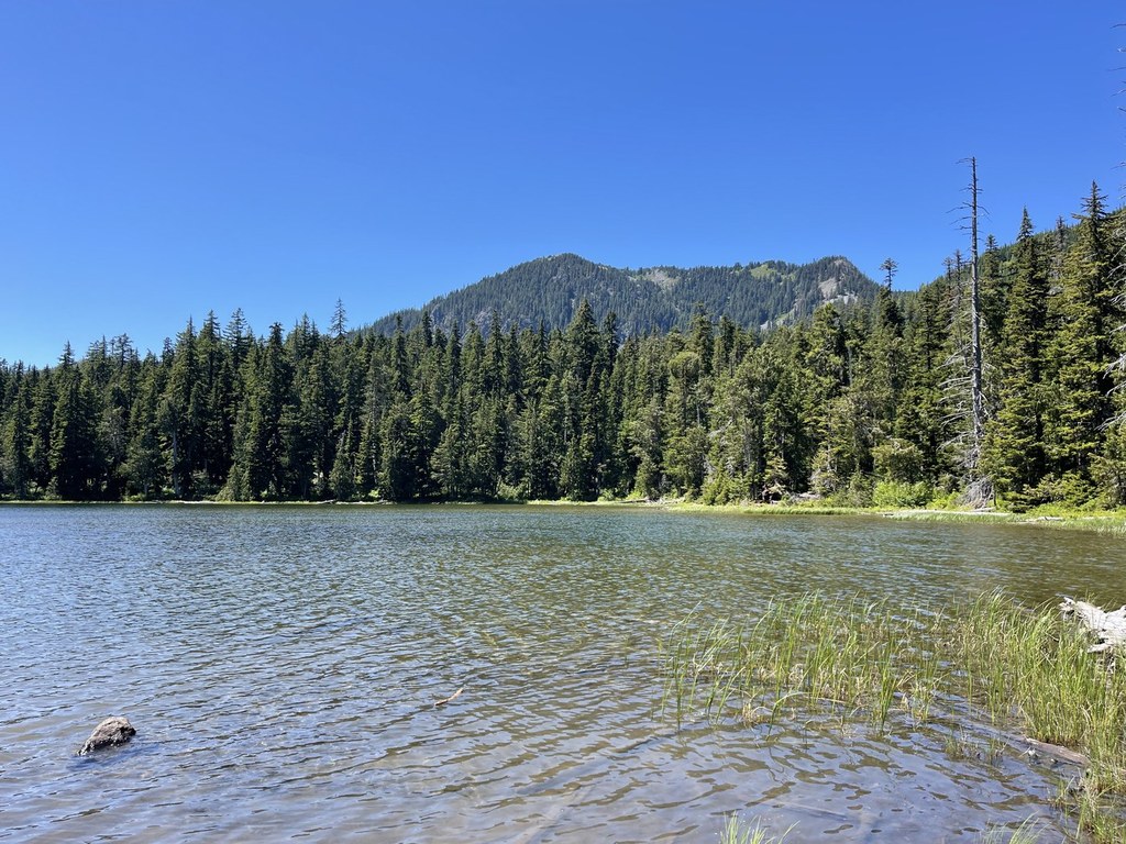
Just before you reach the lake, at a maximum altitude of 3586 feet, the overgrowth opens up, to announce your impending arrival. Follow the trail down to the banks of the lake, 1.2 miles from the trailhead, where Stirrup Creek dumps out. Dragonflies, damselflies, and water skimmers dart back-and-forth. Mosquitoes may bite. To the northwest, Meadow Mountain and its majestic reflection meet your gaze. You may have a close encounter with a hummingbird, but also know that elk and black bears wander through the area, drawn to the berried late summer treasure of this area.

If you wish to see more, the trail continues west along the south shore of the lake and another half mile to Meadow Pass, where you can link up with FR 5483. It is also possible to camp on the shore of the lake next to Stirrup Creek’s outlet.

Toilet Information

  • No toilet at trailhead

More information about toilets

WTA worked here in 2012, 2011 and 2010!

Hike Description Written by
Maxwell Krem, WTA Correspondent

Stirrup Lake

Map & Directions

Trailhead
Co-ordinates: 47.3045, -121.4036 Open in Google Maps

Before You Go

See weather forecast

Parking Pass/Entry Fee

Northwest Forest Pass

WTA Pro Tip: Save a copy of our directions before you leave! App-based driving directions aren't always accurate and data connections may be unreliable as you drive to the trailhead.

Getting There

From Seattle drive east on I-90 and take exit 62, then turn right onto the road at the bottom of the exit (unsigned, Stampede Pass Road). Continue 1.1 miles and turn right onto FR 5480. FR 5480 is unmarked, but there is a sign for “Lost Lake 4 mi -->” and a white fire station at the intersection. After 1.5 miles you will cross a wooden plank bridge. After 1.6 miles on FR 5480, turn left onto (signed) FR 5483. Drive 2.9 miles until reaching (unsigned) FR 5484 and turn left (FR 5484 is marked only by a sign that has orange arrows pointing both left and right). Drive 0.1 mile (for a total of 5.7 miles from I-90) to a small pull-out parking area to your left. On the right, a sign marked “Stirrup Lake Tr. No. 1338” indicates that you reached the destination. The parking area can accommodate 2-3 cars. There is no privy at the trailhead.

More Hike Details

Trailhead

Snoqualmie Region > Salmon La Sac/Teanaway

Stirrup Lake (#1338)

Okanogan-Wenatchee National Forest, Cle Elum Ranger District

Guidebooks & Maps

Green Trails Snoqualmie Pass Gateway No. 207S

Buy the Green Trails Snoqualmie Pass Gateway No. 207S map

You can improve or add to this guidebook entry

Stirrup Lake

48 Trip Reports

Hiked here recently?

Submit a trip report!
 
Trip Reports