
Three-night backpack from Panjab trailhead up Panjab Trail to Indian Corral; Mt Misery Trail east to Sheephead and west to Oregon Butte; return via Turkey Creek Trail.
Looking for a mellow start-of-the-season backpack we had our eyes set on Mount Misery Trail (Misery Highline in Romano's Backpacking Washington). There aren't many trip reports for this corner of the state, especially this early in the season, so we weren't sure what to expect. We learned at Pomeroy Ranger Station that the Diamond Peak trailhead was still inaccessible due to snow on the road (same for Teepee trailhead, which was expected). Hence we had to work a little harder for the easy ridgeline rambling and first climb 2400' up Panjab trail.
Trailhead access: Well-graded gravel road to Panjab trailhead. Diamond Peak and Teepee trailheads inaccessible due to snow.
Trail conditions
- Missing bridge at Panjab trailhead: Both the FS website and WTA hike description say the trail is inaccessible until the bridge is replaced. That's a little misleading. The two creek branches are easily crossed with dry feet via downed trees ~100' upstream from the bridge location. Fording also wouldn't have been difficult through shin~knee-deep water.
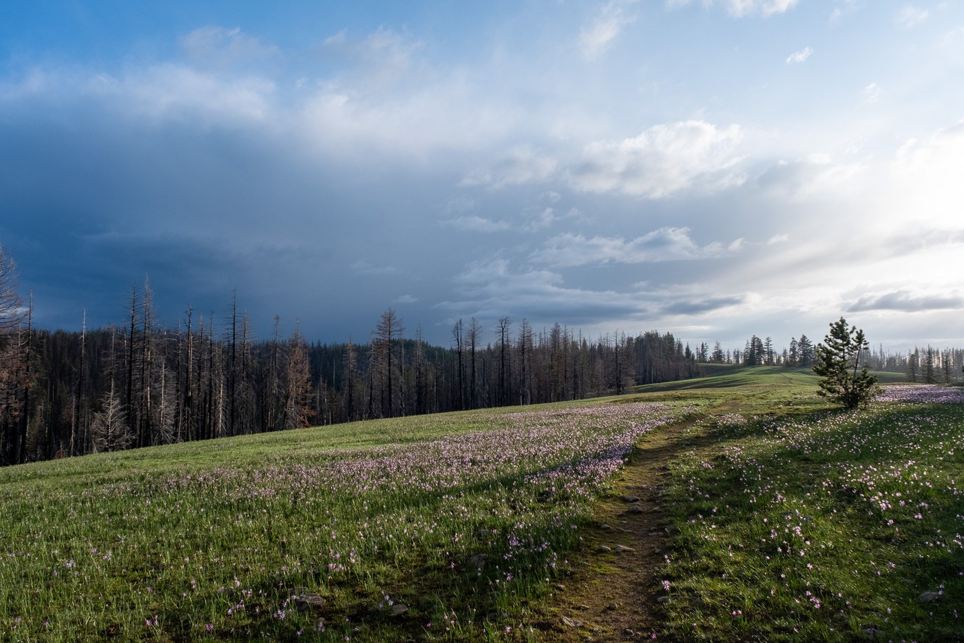
- Panjab trail to Indian Corral: This was the best-maintained section of the trip. Basically no obstacles and mostly obvious tread. Only one point where the trail crosses a creek and almost immediately switches back to the other side had us confused for a moment. I think the climb through burnt sparse forest could get unpleasant in midsummer heat but was quite enjoyable this time of year.
- Indian Corral to Sheephead (day hike eastwards on Mt Misery Trail): Generally good conditions. The forest section between Clover and Bear Wallow Springs is severely burnt and has some blowdowns but nothing difficult. Some patches of snow and muddy sections that probably won't stick around much longer.
- Indian Corral to Oregon Butte: Some more blowdowns and a bit larger snow sections. Nothing dramatic.
- Oregon Butte to Teepee trailhead: We felt this was the least enjoyable section of the trip, at least in relative terms. There wasn't much alive yet in the burnt forest besides mushrooms. Going was slower due to more blowdowns and longer snow sections. Not many views until shortly before the trailhead. Maybe the higher trail over West Butte would have been the more interesting option?
- Turkey Creek Trail from Teepee to Panjab trailhead: Much less maintained than Panjab trail. Some tangled double-blowdowns that need scrambling through. A few somewhat interesting creek crossings and places where the creek had usurped the trail. The denser forest and narrower valley may be desirable in midsummer heat but we were glad we had chosen Panjab for our ascent.
Water: All the springs along the ridge that we checked out were flowing nicely. Snow patches spared us some water carrying when camping high above Oregon Butte Spring.
Campsites: Plenty on the ridge, sometimes with glorious views. Just take care not to disturb the meadows and keep your distance from the many burnt dead trees. Don't put your trust into the campsites Romano promises along lower Turkey Creek: You might be able to find something in a pinch, but we didn't see any obvious dry flat spots that weren't surrounded by burnt snags. There's a flat site at Teepee trailhead, but I wouldn't exactly enjoy camping next to the huge parking area and horse troughs.
Wildflowers: A LOT. It clearly was too early for peak wildflower show. Lupines and Balsamroot hadn't even started yet on the ridge. Shady aspects had the recently melted out brown look. But the sunnier meadows were already carpeted in bright colors by Grass Widows, Glacier Lilies, Spring Beauties, and many others. Lots of Arnica in the valley. Calypso Orchids seem to like the Turkey Creek valley.
Wildlife: Many deer hoof prints, fresh bear tracks, and scat along the ridge trail, but we didn't see any big wildlife. Many small birds that kept their distance. Butterflies were very active along Panjab Creek.
Bugs: No Mosquitoes, yay! Some of the largest ticks I've ever seen, boo!
Weather: The 5000' forecast promised lows around 40 and highs around 60 F, which was probably accurate. However, a stiff breeze made it feel colder much of the time. Some thunderstorms brushed past us, sprinkled a little spray once or twice while hiking, and one night dumped a mighty downpour on our tent. Otherwise a pleasant mix of sun and clouds.
Crowds: Zero. Complete solitude for four days and no sign of recent human visitation on the ridge.
PS: I'm confused about the WTA hiking guide entry for "Mount Misery": Trailhead directions are to Teepee trailhead and the endpoint in the description is Oregon Butte lookout. That hike is much shorter than the quoted 16 miles and already exists in the hiking guide as "Oregon Butte". So it would make sense for this entry to describe the ridge line hike from Diamond Peak trailhead to Oregon Butte. But then the trailhead is wrong (should be same as for "Mount Misery Loop") and the roundtrip distance would be closer to 25 miles.


Comments
Craig Romano on Panjab Trail, Mount Misery, Oregon Butte, Turkey Creek, Mount Misery Loop
Glad you got to this part of the state and had a great adventure. Nice notes and I will update in my book about Turkey Creek. The fire has certainly changed things there. I will be working with WTA member Holly Weiler on a new edition Day Hiking Eastern Washington and we will be hiking all of the trails in this region and updating the info. Happy Trails!
Posted by:
Craig Romano on Jul 06, 2023 04:25 PM
bryan_g on Panjab Trail, Mount Misery, Oregon Butte, Turkey Creek, Mount Misery Loop
Great report! I try to do this loop each spring but missed it this year. Glad to hear the bridge removal didn't affect access too much.
The fire in last 15 years have made significant changes to this area! Hopefully we get enough support over next few years to keep these trails from being lost like so many others in the Wenaha-Tucannon wilderness.
Posted by:
bryan_g on Jul 19, 2023 11:35 AM