Sleep Under Starry Skies: 12 Summer Backpacking Destinations
One of the best rewards after a long hike into the backcountry is relaxing in camp and gazing into a velvety night sky jam-packed with stars.
The Milky Way splashed across the sky is an incredible sight, and amateur and professional photographers alike love to capture scenes of the night sky that only a light-pollution-free area can offer.
There are plenty of backcountry camps all over Washington where campers can enjoy the solitude and majesty of a starry night sky. We've collected just a few hikes that are gorgeous during the day, so your trip to camp is as scenic and beautiful as your evening stargazing time.
Stargazing tips
Remember that stargazing can be fun, but any time you're walking around in the dark, there are some special considerations.
- Step carefully. It may seem obvious, but scope your stargazing spot with safety in mind.
- Save your eyes (and your companions) from light blindness by using the red setting on your headlamp or flashlight. If you don't have a red light, simply tape some red saran wrap over the light.
- Bundle up! Dress warmly and sip some hot tea, cocoa, or broth to stay warm as night falls.
- Heading out in the winter? Check out our tips for exploring the winter nighttime sky.
Backpacking tips
- Before heading out for an overnight, review the backpacking basics.
- Check trip reports and contact a ranger before heading out for an overnight. Some of the trails below may have snow on them well into summer, and you may need a permit to stay overnight at some of these camps.
- Check (and recheck) weather conditions to find cloud-free skies.
Central Cascades
Schaefer Lake
Location: Stevens Pass -- East
Length: 10.0 miles, roundtrip
Elevation Gain: 2700 feet

Schaefer Lake reflecting the surrounding hills. Photo by trip reporter Lucy.
Schaefer Lake is a great day hike destination, but it's just long enough and has just enough elevation gain that you may want to reward yourself with an overnight in this scenic lake basin. And the peaks all around you are sure to block out any light pollution, making it truly dark for the late-night stargazing.
> Plan your visit to Schaefer Lake using WTA's Hiking Guide
Chiwawa River
Location: Stevens Pass -- East
Length: 12.6 miles, roundtrip
Elevation Gain: 2100 feet

The trail to Chiwawa River offers gorgeous views. Photo by mattslagle.
The Chiwawa River Trail offers hikers the rugged scenery that's the signature of the Glacier Peak Wilderness but for less effort than other hikes nearby. Try this trail to enjoy solitude while basking in sublime mountain scenery. There are also great campsites to set up home away from home while you wait for the stars to come out.
> Plan your visit to Chiwawa River using WTA's Hiking Guide
Mount Rainier
Dewey Lake
Location: Chinook Pass - Hwy 410
Length: 6.0 miles, roundtrip
Elevation Gain: 1270 feet

Burned forests give way to wide open views at Crow Lake Way. Photo by Ryan Cavanaugh.
Dewey Lake is a great location near Mount Rainier, so it's quite popular and you'll definitely want to arrive early to get both a spot in the parking area and a spot at the lake. But the hike is gorgeous, and the wildflowers are gorgeous. Do be aware that in the early summer this trail can get muddy.
> Plan your visit to Dewey Lake using WTA's Hiking Guide
South Puyallup to Klapatche Park
Location: Longmire/Paradise
Length: 18.6 miles, roundtrip
Elevation Gain: 5000 feet

Klapatche Park has great views of both the nighttime sky, and the mountain. Photo by Joey Smith.
This section of the Wonderland Trail is a great overnight option for stargazing. Klapatche Park is a high-elevation campsite with minimal tree cover and an incredible view of Mount Rainier to serve as a background for your nighttime photography. Make sure you snag a backcountry permit for this one ahead of time!
> Plan your hike on the South Puyallup trail to Klapatche Park using WTA's Hiking Guide
Snoqualmie Region
Kaleetan Lake
Location: North Bend Area
Length: 20.2 miles, roundtrip

A nice, impacted campsite near Kaleetan Lake. Photo by gavinforster.
Kaleetan Lake is an easily accessible route off of I-90 that takes hikers into the popular Alpine Lakes Wilderness. After a forested approach and after passing by a few other lakes, you'll land at Kaleetan Lake. Kaleetan Peak stands directly at the opposite end of the lake, a view worth the price of admission, paid in sweat and sore feet.
> Plan your visit to Kaleetan Lake using WTA's Hiking Guide
Spade Lake
Location: Salmon La Sac/Teanaway
Length: 25.6 miles, roundtrip
Elevation Gain: 5200 feet

A view of Spade Lake from above. Photo by Sheep.Deep.
Starting from the Waptus River Trail, Spade Lake can be reached via a steep, uphill climb through old-growth. It's is a lovely, lonesome lake nestled in a rocky cirque high on Mount Daniel. Because it's a hefty hike to access, it's once of the more remote lakes in the Alpine Lakes Wilderness.
> Plan your visit to Spade Lake using WTA's Hiking Guide
South Cascades
Loowit Trail
Location: Mount St. Helens
Length: 28.0 miles, roundtrip
Elevation Gain: 6,000 feet

The starscape above the mountain at night. Photo by FilipTD.
The Loowit Trail has plenty of wide open camps to take in the night sky. Plus, it's far enough away from most major cities that campers will be truly stunned by the skies overhead. If you're not up for a 28 mile hike, try the eight-mile Plains of Abraham Loop. Just know that camping is not permitted between the South Fork of the Toutle River and Windy Pass.
> Plan your hike on the Loowit Trail using WTA's Hiking Guide
Stagman Ridge - The Bumper
Location: Mount Adams Area
Length: 12.0 miles, roundtrip
Elevation Gain: 1900 feet

A milky creek running through a meadow along the Stagman Ridge Trail. Photo by aubrey.white.13.
Campsites in Horseshoe Meadow will give overnighters comfortable accommodations for stargazing. During the day, the hike into camp offers excellent insight into a wide variety of Washington ecosystems, from a forest recovering from wildfire to austere alpine splendor, to views of Mount Adams.
> Plan your visit to Stagman Ridge and the Bumper using WTA's Hiking Guide
Southwest Washington
Observation Peak
Location: Southwest Washington -- Lewis River Region
Mileage: 5.0 miles, roundtrip
Elevation Gain: 500 feet

Wildflowers foregrounding a wide open view. Photo by trip reporter Fighting Quaker.
The site of a former fire lookout, Observation Peak offers extensive views of the South Cascades and the Goat Rocks for a relatively short hike. But it's important to note that there are a couple of different approaches to the summit — most people start from the Trapper Creek Trailhead.
> Plan your hike to Observation Peak using WTA's Hiking Guide
Olympic Peninsula
South Coast Wilderness Trail
Location: Pacific Coast
Length: 17.0 miles, roundtrip
Elevation Gain: 250 feet

The orange sunset peeking through the rocks. Photo by mattj19.
What better place to see the stars from an unobstructed campground than along the coast? The South Coast Wilderness Trail will keep you busy for three days of coastal trekking. At night, backpackers can enjoy not only stunning sunsets, but a night horizon full of stars.
> Plan your visit on the South Coast Wilderness Trail using WTA's Hiking Guide
Moose Lake
Location: Northern Coast
Length: 8.2 miles, roundtrip
Elevation Gain: 1,500 feet

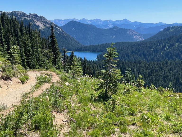
Looking down at Moose Lake sitting below a rocky peak with patches of snow. Photo by trip reporter spaceistheplace.
Start high and head low to little Moose Lake. Camping here requires reservations, as with so many locations in Olympic National Park, but it's well worth it, for the stunning scenery during the day and quiet and peace at night.
> Plan your trip to Moose Lake using WTA's Hiking Guide
Central Washington
Sun Lakes - Dry Falls State Park
Location: Grand Coulee
Length: 6.0 miles, roundtrip
Elevation Gain: 350 feet

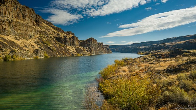
Deep lake surrounded by dry grasses and a rocky promontory. Photo by demonstrate.
The trails at Sun Lakes-Dry Falls State Park are great for slightly more advanced backcountry hiking. Camp at the frontcountry campsite, then head back into the park when the stars come out. Just be sure to bring a flashlight or headlamp, and consider doing a scouting hike in the daylight so your first trip in isn't at night.
> Plan your visit to Sun Lakes - Dry Falls using WTA's Hiking Guide
Eastern Washington
Panjab Trail
Location: Palouse/Blue Mountains
Length: 5.6 miles, roundtrip
Elevation Gain: 2500 feet

If you're feeling up for it, you can connect the Panjab Trail with Oregon Butte to get views like these. Photo by trip reporter RichP.
Hike the Panjab Trail to its end and revel in the destination -- a beautiful, wide-open alpine meadow full of wildflowers. Once you arrive, look for a camp at Indian Corral and settle in, the light show will begin as soon as the sun has its curtain call.
> Plan your hike on the Panjab Trail using WTA's Hiking Guide
Thirteenmile
Location: Kettle Range
Length: 16.0 miles, roundtrip
Elevation Gain: 2000 feet

Wide open sky views at Thirteenmile. Photo by Todd.
With miles of roaming in rolling, remote parkland, the Thirteenmile Trail is a great choice for new and seasoned backpackers alike. Hike in two miles or eight miles -- anywhere along the generous ridgeline makes for great overnight camping and stargazing.
> Plan your visit to Thirteenmile using WTA's Hiking Guide
North Cascades
North Fork Entiat River
Location: Entiat Mountains/Lake Chelan
Length: 26.0 miles, roundtrip
Elevation Gain: 4000 feet

Mountain views from one of the many campsites on the North Fork Entiat Trail. Photo by trip reporter chrisburke.
Challenge yourself on this long backpacking trail that includes a multitude of locations for prime stargazing. Be flexible for this trip, since conditions change frequently on trail here.
> Plan your hike on Copper Ridge using WTA's Hiking Guide
Twisp Pass
Location: Methow/Sawtooth
Length: 9.0 miles, roundtrip
Elevation Gain: 2460 feet

Yellow larches sprinkled on the hillside on the Twisp Pass Trail. Photo by trip reporter JustLikeHiking.
A gorgeous destination in and of itself or a gateway to further days of wandering, Twisp Pass is a stunning place to be for sunset and the star show afterwards. Head here and you're sure to get one heck of a view on a clear night
> Plan your trip to Twisp Pass using WTA's Hiking Guide
- Check out more locations: Didn't see a spot that works for you listed above? Search our Hiking Guide, browse trip reports, or see what our Facebook community had to say about where they go to lie beneath the stars.

