Pacific Crest Trail (PCT) Section J - Snoqualmie Pass to Stevens Pass - East
Imagine not crossing a road for 75 miles! Backpackers who complete the Snoqualmie - Stevens segment of the Pacific Crest Trail will hike through some of the most remote and diverse mountain country along the entire 2650-mile trail.
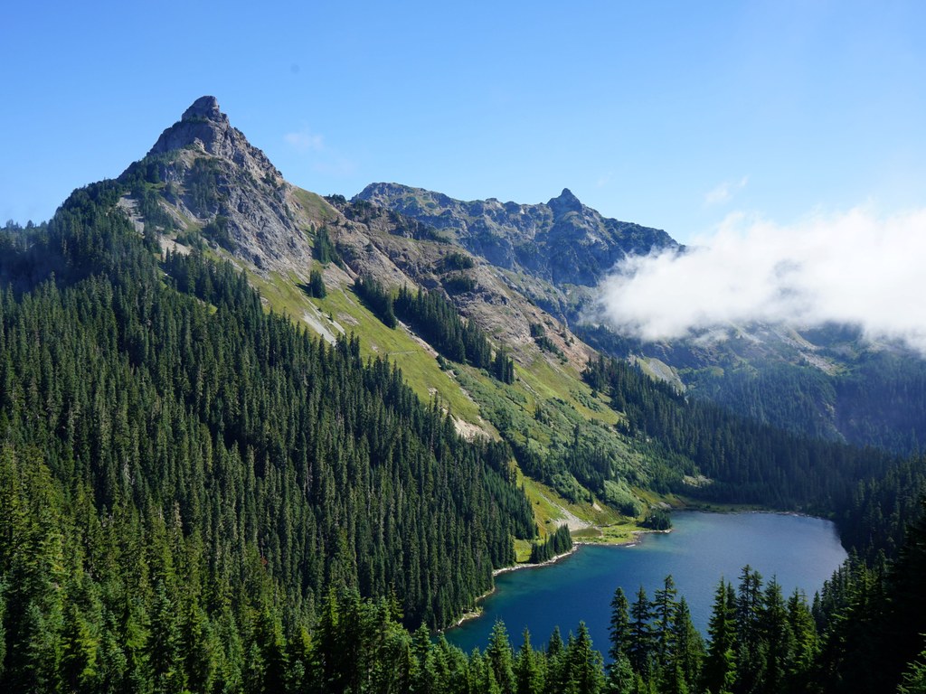
The route traverses the Alpine Lakes Wilderness, and the trail passes by a least a dozen lakes along the way, many of them swimmable in late-summer. But the lakes aren't the only attraction - you will encounter meadows, old growth and views of towering mountains. This trail is not for the beginning backpacker. There is considerable elevation gain (and loss) - 16,000 feet! Some places are impassable until well into August when the snow melts out. And the distance requires hikers to carry six or seven days of food and arrange for a car shuttle or pick-up at Stevens Pass. It is best for hikers of this segment to pick up a map from the Pacific Crest Trail Association (www.pcta.org) and buy the Pacific Crest Trail Oregon & Washington guidebook by Jeffrey Schaffer and Andy Selters published by Wilderness Press. The details this book provides cannot possibly be matched in a short online hiking guide description.
Driving Directions:
From Seattle drive I-90 to exit 52 (signed for Snoqualmie Pass west). At the bottom of the exit ramp, turn left (north) and cross under the freeway. In about 100 yards, turn right onto a dirt road leading into the PCT trailhead. At Stevens Pass, the PCT exits at the crest near the ski area. Recent Trip Reports
Hiked here recently?
Submit a trip report!
There are
46
trip reports for this hike.
See all trip reports for this hike.
Pacific Crest Trail (PCT) Section J - Snoqualmie Pass to Stevens Pass - East
— Sep 24, 2011
— john deer
Day hike
Expand report text
Hide report text
Read full report
This is a popular trail on a nice weekend day - both the hiker parking lot and horse lot were...
This is a popular trail on a nice weekend day - both the hiker parking lot and horse lot were overflowing by the time I rolled in at a leisurely 10 am. I had been out hiking a lot lately so I hoped I could do a round trip as far as Joe Lake and I almost made it that far.
All of the blow downs and snow that were around in mid August are gone now. They have been replace with another trail nuisance - unleashed dogs and jerk wad owners that insist it is OK to let them run loose. In spite of that the trail and views were very nice - Guye Pk, Snoqualmie Mt, Red Mt, Denny, The Tooth, Chair, Roosevelt, Kendall, Alaska, Chikamin, Stuart, etc. I thought the crowds might thin out as I passed the Katwalk but there were still a lot of folks well beyond that point. Fortunately, the dogs were not. There were probably 6 or more tents at the Ridge/Gravel saddle. Past that point, there were only a few people; some trail runners; one guy doing a one-way hike from Gold Creek; and a few others. There were more views of peaks plus the lake views of Alaska, Joe, and Edd Lakes - all well below the trail and un-visited by me on this day. On the return trip, the elected for the short cut via the old PCT. It was about a mile shorter but required the double crossing of Commonwealth Ck plus some brushy areas lower on the trail. Multi-night backpack
Features:
Wildflowers blooming | Fall foliage | Ripe berries
Issues:
Blowdowns | Bridge out | Overgrown | Mudholes | Bugs
Expand report text
Hide report text
Read full report
with photos
Day One: Left Stevens Pass and ended up spending the night at Trap Lake, bugs were heavy, but manageable. The...
Day One: Left Stevens Pass and ended up spending the night at Trap Lake, bugs were heavy, but manageable. The trail to this point was in fine condition.
Day Two: Made our way to Deep Lake, the trail was in good shape through here as well, the ford across Daniel Creek was easy and largely safe for most skill levels, I saw no way to get across in a timely dry fashion, so in we went. The hike down to Deep Lake seemed like forever, I believe this is where I started to notice the PCT's habit of having long, long switchbacks. The bugs at Deep Lake weren't as bad as I'd heard. Day Three: Hiked to Waptus River bridge before taking a break, then headed up the hill there, this is the first section that was really in need of some brush clippers, the Alder is trying to reclaim the trail. This night we camped not far from the Escondido Tarns area. It started raining a bit that night. Day Four: We made it down to the Lemah Crossing after a long, long series of switchbacks over much blowdown, finding one bridge in solid shape and the other completely gone. The crossing here was not difficult or dangerous however. The trail then took us through a burn and up to Spectacle Lake. We had decided earlier to make Huckleberry Mountain our next camp so we headed out, the rain came in waves. Reaching Spectacle Point the horizon became black with clouds and the wind was cold and fast. We decided there we'd just make a go at hiking out. After a long windy and rainy walk through some of the best, albeit obscured by clouds, scenery on the whole hike, we made it to the Katwalk in fading light and by the time we saw the freeway, the light was nearly expired. We made our way to the trailhead with flashlights. Phew! What a day! Overall: Water was abundant in most all locations, bugs were generally not a nuisance, trail was generally in great condition and camping was often ample. Highly recommend this trip, Happy Trails!
Pacific Crest Trail (PCT) Section J - Snoqualmie Pass to Stevens Pass - East, Joe Lake, Spectacle Lake, Pete Lake, Kendall Katwalk
— Sep 03, 2011
— TRAILer Trash
Multi-night backpack
Features:
Wildflowers blooming | Ripe berries
Issues:
Blowdowns | Bridge out | Bugs
Expand report text
Hide report text
Read full report
We headed out from Snoqualmie Pass in a group of 5 following the pct. Labor Day weekend was perfect as...
We headed out from Snoqualmie Pass in a group of 5 following the pct. Labor Day weekend was perfect as far as the weather goes! The trail ascended fairly gradual with few downed trees on the way up to Kendall Katwalk. After the katwalk there were a few patches of snow, but nothing sketchy at all; the snow was about 100ft wide.
We decided to stop at Joe Lake to call it a night, not realizing that the lake is fairly far away and you have to bushwack through heavy underbrush down a steep hill. Luckily we found a snow patch close to the trail with water running out of it (the stream is marked by orange markers). The way from Joe Lake to Spectacle Lake was snow free and BEAUTIFUL! There are wild flowers for miles and the view is spectacular! At Spectacle Lake the bugs were a little heavy at times and we got pretty bit up, but it's worth the torment to experience the beauty of the lake. After Staying at Spectacle Lake we headed down the pct and took the junction toward pete lake. The trail to the trail head was extremely flat and was a great way to end our nearly 30 mile trip. DO THIS TRIP! IT IS AWESOME! Multi-night backpack
Features:
Wildflowers blooming
Issues:
Blowdowns | Bridge out
Expand report text
Hide report text
Read full report
with photos
I planned to do this trip 10 years ago, light and fast over a weekend. Finally it was time to...
I planned to do this trip 10 years ago, light and fast over a weekend. Finally it was time to make it happen... but having 10 years go by, I thought a nice long weekend would be a better proposition. There is always the trade - when you add days, you need to carry more food.
To cut to the chase for those that want to know about the trail, it is in great condition. Still some blowdowns, still minor patches of snow, bridge still out at Lemah crossing, still have the "treacherous" crossing above Hyas lake... but all of it doable quite easily. The bridge out is supported by a sufficient log crossing 20 feet down stream - didn't get my feet wet. The treacherous crossing - plan on wet feet. Best bet is with Tevas/Keens/ other water sandals, using trekking poles just plow through the water. Be careful the wet rocks are extremely slippery! so don't plan on rock hopping. Wildflowers were abundant and beautiful everywhere. Wildlife, I saw a moutain goat mom and her kid on the north side of Huckleberry, and I saw a good size buck crashing through the woods just before the Lemah creek crossing... oh, and some brown toads around the ponds on Esconido ridge area. My trip: Day 1, Snoqualmie pass to Spectacle lake - about 19 miles. I think the hardest day, but with the most spectacular views. Day 2, Spectacle lake to Deep Lake - ~26 miles - the saunter over escodido ridge was a highlight of scenic beauty. The top of the ridge essentially marks the end of teh blowdowns for the duration of the trip. And the trail from here to the end seemed in general easier going. Day 3: Deep Lake to Hope Lake ~22 miles - longer than it needed to be, but Trap Lake looked crowded and I wanted to make my final day a short one. Snow on the North side of Surprise peak is pretty much the most I saw anywhere. Day 4: Hope Lake to Stevens Pass ~ 8 miles. least enjoyable scenery of trip, including power lines, ski-lifts and generally tree-covered views. But exhilarating to get it done! My food plan - because I found it worked and has some nice benefits: Breakfast was a 1 liter water bottle of protein mix. Gets you going in the morning quickly and good start to hydration. The day was spent drinking a couple or more liters of water with energy/recovery drink mix (P90x formula if you need a recommendation). And snacking on some trail mix (nuts and berries), A protein bar each day, and Turkey Jerky. Late lunch/dinner consisted of the Mountain House "Chicken Wrap" where you just add cold water... I added more than required to make it more like a soup that I drank rather than filling any tortillas. Benefits: Notice no cooking required = no stove or fuel. And secondly, pretty close to a liquid diet, and if your protein powder is highly digestible means... very little digestive waste - for me one stop the entire trip. My total pack weight was 25lbs at the start, plus 6lbs of camera gear. Ok, so it CAN be done in 3.5 days, heck even less if you are gung-ho. But despite my sense of accomplishment, I do NOT recomment doing this trip this fast. First the obvious reason is you don't have as much time to go slow and enjoy the scenery or take a dip in a few of the inviting lakes (Deception lake(s) was quite inviting - but had to press on. But more important to me, from a photographic point of view, is that my 20mile days just happen to put you camping at low points = lakes along the way. It seems that 5x15 mile days would better line you up for higher camps, providing better morning/evening light, provided you are willing to pack water up to potentially dry high points. My recommendation for future high point camps are as follows: 1. Col between Huckleberry and Chikamin ridge - had some water in ponds. 2. Park Lakes area, or the final ridge before dropping down to spectacle lake. 3. Anywhere along the top of Escondid ridge area... and it has sone mice lakes and ponds (in particular the little lake on the south side of the ridge. 4. Some nice camping areas on the East side of Cathedral peak (Or Peggy's pond - though I didn't go there this trip). (Might find ponds nearby). 5. The col between Trap and Surprise lake. (No water) Taking a 6th day would give plenty of time to smell the roses and pick the select camping spots to meet your interests. Enjoy! Day hike
Features:
Wildflowers blooming | Ripe berries
Issues:
Blowdowns | Bridge out | Overgrown
Expand report text
Hide report text
Read full report
with photos
Summary: 55 mile run / hike, start at Snoqualmie Pass, PCT to Waptus lake, then Lake Ivanhoe to Dutch Miller...
Summary: 55 mile run / hike, start at Snoqualmie Pass, PCT to Waptus lake, then Lake Ivanhoe to Dutch Miller Gap, Goldmeyer Hot Springs, Old PCT to Red Mtn Pass, Commonwealth Basin back to Snoqualmie Pass. Plan: 11 hours Actual: 16 hours Bringing headlamps was a wise choice....
The entire loop was done in running shoes. No poles or traction devices are needed. Lots of ripe berries along the way. The long story, with trail detailed trail conditions for each section: Adam Lint and I set out at 7:15am on Sunday morning from the PCT trailhead at Snoqualmie Pass. There are several trees across the trail on the climb to Kendall's Catwalk, but easy to get around / over. May be 1/2 mile past the junction with the Commonwealth Basin trail the PCT crosses an open area (avalanche path in the winter). The actual trail just crosses the open area. If you don't pay attention you (like us and many others) might follow a false trail uphill that ends after 50 - 100 yards. The rest of the way to the Catwalk is in good condition with no snow on the trail. After the Catwalk there are a few snow patches but the entire PCT section of the trail to Waptus Lake is runable. Got to Park Lakes in about 3 hours, then descended partly through burned-out forest, crossing the outflow of Spectacle Lake (Delate Creek) on a solid bridge. The bridge over Lemah Creek is gone, but there is log across a little downstream. About a mile later you cross another creek (not sure of its name) on a solid bridge. Get some water here as the climb up Escondido Ridge is long and dry (except for a smaller creek near the start of the climb). Eventually the trail flattens out and you pass several small lakes / ponds. The section just above Escondido Lake has seen some recent trail work as the tread is very new. The 3.7 miles (Green trails map) from trail 1329 down to the trail 1362 junction seems to be a little longer than 3.7 miles... got there at 3:00pm. trail 1362 to Lake Ivanhoe and Dutch Miller Gap. This is where my problems really started. My stomach hadn't been feeling that good before, but after drinking some water it came back out, and then some. Trail is in great shape, but I wasn't, so we ended up walking most of the way to Lake Ivanhoe. It's one of the most scenic lakes I've seen, surrounded by rugged peaks and cascading waterfalls. Just before the Lake the trail splits, and we chose to go around the lake clockwise. You have to cross the outflow of Lake Ivanhoe here on a broken, but still in place bridge. As you begin the final climb to Dutch Miller Gap you cross a creek cascading down on exposed granite, and then down into the lake. Dutch Miller Gap to Goldmeyer Hot Springs, trail 1030: First mile is pretty steep down, then flattens out near the junction with Williams Lake. Still couldn't eat / drink much and we jogged most of the downhills, and walked the occasional uphills and the overgrown sections (about a mile total ove overgrown areas, but almost all soft stuff, no salmonberries or other thorny stuff). Trail is easy to follow... Eventually made it to the road and decided to run down the road instead of the trail to the hotsprings. (You have to follow the road for about 1/2 mile anyway, but then you have the option of turning off onto the Middle Fork Trail for the the last 3 miles to the hotsprings.) Go to the hot springs at about 7:10pm. Did not feel good and threw up again. Katie, the caretaker at the hotsprings, was very helpful and made me some ginger tea, and also sent an e-mail to my wife that we'd be later than expected, and not the call S&R. Left the hot springs at 7:30pm. Goldmeyer Hot Springs to Red Mtn Pass - Old PCT. At this point we had about 1 hour of daylight left... Immediately after crossing Burnboot Creek on the log bridge (very easy crossing) we turned left on a indistinct looking trail (look for a small sign for "red mtn pass 4 miles") upstream. The trail follows the creek upstream for about 200 meters and then starts climbing unrelenting with many switchbacks towards Red Mtn Pass (1800ft to 5300 ft). Bring plenty of water as there is NO water available until close to the top. There are several trees across the trail, but they pose no problem to the avid hiker. In some sections, especially the upper part of the trail, huckleberry bushes start to overgrow the trail a bit, but even in the dark it was no problem to follow the trail. Eventually you ascent above treeline and the trail switchbacks up next to a snowfield, which as of Aug. 30th was still in part covering the trail. Once you reach the "false summit" you're almost there, at least elevation-gain wise. Now the trail descends slightly and crosses a talus field before the final push up a gully to Red Mtn Pass. There were several snowfields covering the trail leading up the the gully. Fortunately there was about a 2-5 ft gap between the rockwall on the right and the snow fields on the left. At one point the snow was about 10 ft thick, but had a 4 ft high snow cave under it for us to pass through. Would have been super cool if I had felt better. The gully was still partly snow-covered, but even in the dark with just running shoes and a stick we picked up along the way we were able to make it up without too much trouble. We reached Red Mtn Pass at 9:30pm. View of the sky and Milky Way was awesome. Even saw a shooting star. Commonwealth Basin trail 1033. Trail's in good condition, kind of steep and rocky in the upper part for descenting at night. Commonwealth creek crossing on a log was easy. We chose to descend the PCT rather than the somewhat shorter trail because we didn't know how easy it would be to follow that trail in the dark. Threw up one more time on the way down. Got to the car by 11:30pm. |
Cathedral Rock. Photo by Steve Podleski.
2010, 2011
Map it
|
Document Actions
- Email this page
- Print this
- Share


