Trails for everyone, forever

Home Go Hiking Hiking Guide Chatter Creek

Chatter Creek

Central Cascades > Leavenworth Area
47.6086, -120.8820 Map & Directions
Length
11.4 miles, roundtrip
Elevation Gain
4,959 feet
Highest Point
6,692 feet
Calculated Difficulty About Calculated Difficulty
Hard
Chatter Creek Trail by Jessica Wynne Full-size image
  • Dogs allowed on leash
  • Established campsites
  • Fall foliage
  • Mountain views
  • Ridges/passes
  • Rivers

Parking Pass/Entry Fee

None
Saved to My Backpack

No matter how you tackle it, this hike is a workout. March through thick Ponderosa forests up to subalpine larch stands and a view from the pass, with options to continue on for a small alpine lake with backcountry campsites and access to other wilderness trails. Continue reading

Rating
4.00 out of 5

(4 votes) Log in to rate

Hiking Chatter Creek

The trail begins at the Chatter Creek Trail sign on the northwest side of the parking lot. At first, the dirt trail is flat, hugged by vine maple that turns crimson in the fall. The initial incline is mild and rolling, lulling you into a sense of gentle exertion. Throughout portions of the trail, expect it to be brushy and almost overgrown at times.  At 1 mile, cross a footbridge over Chatter Creek. 

With this warm-up section behind you, the trail begins to climb more steeply, averaging a 20% grade over the next mile. At 1.2 miles, cross into the Alpine Lakes Wilderness. The trail is mostly dirt with some rocky sections. 

At 2.3 miles, there is a water source and at least four forested backcountry campsites. Between August and September, this could be the last reliable water source until you’re almost done climbing to the pass. A seasonal water source is available at 2.6 miles. Another viable campsite is located at 3 miles, but there is no water without a walk.

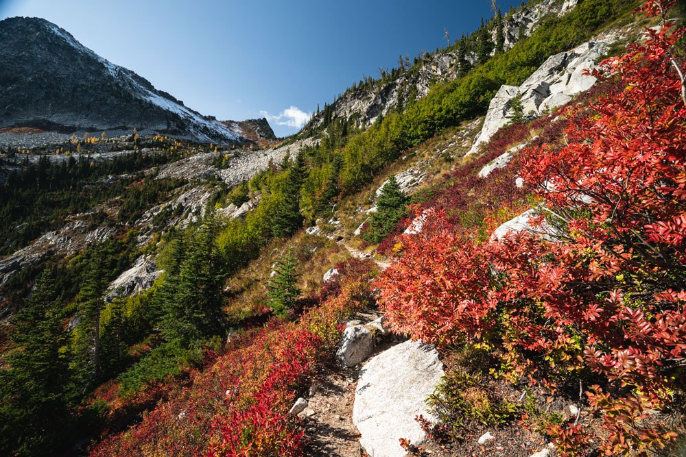
The views begin to open up as you climb out of the dense forest. A seasonal water source may be available at 3.8 miles. The trail gives you a break with a lower grade, showcasing views of the basin below Grindstone Mountain. Soon, you will be looking down on the area you’re traversing.  

The next mile rises another 1,300 feet as you ascend to the pass. The trail can be very rocky and steep, with almost no shade. When you stop to catch your breath, listen for pikas chirping from the boulder fields. Near the pass, at about 4.8 miles, find a seasonal water source on the left of the trail, and a small, exposed campsite on the right.

Reach the pass and take in the views. At this point, you’ve climbed about 4000 feet in 5 miles. The views here are expansive, so if you’ve had your fill, this is a reasonable turnaround point. You may choose to extend your trip to view the golden larches or Lake Edna. If so, continue northwest over the pass. Be aware that even in early fall, there can be ice and snow on this side of the pass as it is shaded the entire day. 

After a short descent, the trail heads left, winding around large boulders. If there is snow, the trail can be easy to lose. There are small streams throughout the area. At 5.7 miles, reach the end of the Chatter Creek Trail as it joins with the Icicle Ridge Trail. From here, you can turn around, or continue on to Lake Edna and beyond.

Toilet Information

  • No toilet at trailhead

More information about toilets

Hike Description Written by
Jessica Wynne, WTA Correspondent

Chatter Creek

Map & Directions

Trailhead
Co-ordinates: 47.6086, -120.8820 Open in Google Maps

Before You Go

See weather forecast

Parking Pass/Entry Fee

None

WTA Pro Tip: Save a copy of our directions before you leave! App-based driving directions aren't always accurate and data connections may be unreliable as you drive to the trailhead.

Getting There

From Highway 2 on the western edge of Leavenworth, at the traffic circle, take Icicle Road out of town (if heading east on US-2, first exit; if heading west, second exit). Follow for 8.4 miles, then continue onto NF-7600.

The road becomes gravel, continue for 6.5 miles. Watch out for occasional potholes.Turn right into the Chatter Creek Trailhead parking lot. If you pass the Chatter Creek Campground, you’ve gone too far. Gravel lot has room for approximately 20 vehicles. There are no facilities at this trailhead.

More Hike Details

Trailhead

Central Cascades > Leavenworth Area

Chatter Creek Trail (#1580)

Okanogan-Wenatchee National Forest, Wenatchee River Ranger District

Guidebooks & Maps

Alpine Lakes Wilderness, Nathan Barnes & Jeremy Barnes, Mountaineers Books

Pacific Northwest Hiking, Scott Leonard & Sean Patrick Hill, Avalon Travels

USGS Chiwaukum Mountains

USGS Jack Ridge

GreenTrails #177, Chiwaukum Mountains

Adventure Maps Inc, Alpine Lakes Wilderness Map & Guide

Buy the Green Trails Chiwaukum Mtns No. 177 map

You can improve or add to this guidebook entry!

Chatter Creek

191 Trip Reports

Hiked here recently?

Submit a trip report!
 
Trip Reports