Trails for everyone, forever

Home Go Hiking Hiking Guide Vanson Ridge

Vanson Ridge

South Cascades > White Pass/Cowlitz River Valley
46.4176, -122.1724 Map & Directions
Length
3.3 miles, one-way
Elevation Gain
1,730 feet
Highest Point
4,100 feet
Calculated Difficulty About Calculated Difficulty
Moderate
Green River Valley from Vanson Ridge. Photo by Dream Delay. Full-size image
  • Dogs allowed on leash
  • Established campsites
  • Lakes
  • Mountain views
  • Old growth
  • Ridges/passes
  • Rivers
  • Summits
  • Wildlife

Parking Pass/Entry Fee

None
Saved to My Backpack

Vanson Ridge is a 3.3-mile connector trail between the Goat Mountain and Green River trails in Mount St. Helens National Monument. A welcome respite for many thru-hikers traveling the Goat Mountain loop route, it is also popular with mountain bikers as an exciting offshoot of the Green River trail. Continue reading

Rating
3.00 out of 5

(6 votes) Log in to rate

Hiking Vanson Ridge

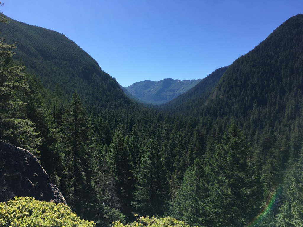
At a distance of 5.5 miles from the parking area for the Green River trail along FR 2612, turn right at the junction with Vanson Ridge trail. Follow amidst lush greenery as it twists and turns under towering old-growth Douglas fir and western red cedar for a half-mile. The trail then begins to switchback up the ridge, and in another two-tenths of a mile over a total of 450 feet elevation, arrives at a small rocky outcropping and incredible viewpoint over the Green River Valley.

Continuing your exploration, hike up another 1,375 feet over about 2.5 miles on varying degrees of forested switchbacks. Be mindful and alert that mountain bikers frequent this area. There are multiple small creek crossings for water filtering here, and many more partial views of the valley through the trees.

At 3.3 miles, reach a junction. Here, you have the options of visiting Vanson Lake or Vanson Peak. For the lake, turn right onto Goat Mountain trail and follow 0.5 mile, veering right onto Vanson Lake trail and descending to the lake in 0.25 mile. For the peak, pass straight through the junction and onto the signed trail for Vanson Peak. Ascend steeply over about a mile and 800 feet of elevation. Reaching a clearing bordered with blooming beargrass and a rocky outcropping, take in the outstanding views of Mount Rainier, Mount Adams and nearby Riffe Lake.

Toilet Information

  • No toilet at trailhead

More information about toilets

WTA worked here in 2012 and 2010!

Hike Description Written by
Josh Machniak, WTA Correspondent

Vanson Ridge

Map & Directions

Trailhead
Co-ordinates: 46.4176, -122.1724 Open in Google Maps

Before You Go

See weather forecast

Parking Pass/Entry Fee

None

WTA Pro Tip: Save a copy of our directions before you leave! App-based driving directions aren't always accurate and data connections may be unreliable as you drive to the trailhead.

Getting There

From Randle, drive 8 miles south on FR 25. Just after crossing the Cispus River, turn right onto FR 26 (paved). Continue 12 miles until a junction with FR 2612 and turn right. Continue 0.4 mile to the trailhead.

Alternatively, from Morton, follow the Goat Creek guide entry directions to the end of the bridge across Riffe Lake/Cowlitz River. Take a left here onto FR 2742, follow past the Cowlitz Falls Dam to where it intersects with FR 25 and Huffaker Bridge. Take a right onto an uphill gravel road, FR 26. Follow this eventually paved road to FR 2612. Continue for 2.6 miles, bearing left at a curve with an unsigned intersection and find the signed trail crossing the road. Park on the road shoulder.

More Hike Details

Trailhead

South Cascades > White Pass/Cowlitz River Valley

Vanson Ridge (#213.1)

Gifford Pinchot National Forest and Mount St. Helens National Volcanic Monument

Guidebooks & Maps

Day Hiking: Mount St. Helens (Romano & Theisen - Mountaineers Books)

Buy the Green Trails Mount St. Helens NVM No. 332S map

You can improve or add to this guidebook entry!

Vanson Ridge

9 Trip Reports

Hiked here recently?

Submit a trip report!
 
Trip Reports