Hike the State 2025: Four WTA staff share favorite fall hikes
Get excited for your next adventure with four WTA staffers as they reveal some of their favorite hikes from around the state. No matter your preferred type of trail, there's something here for everyone. Get ideas to help you plan an unforgettable autumn and sample some bigger trips you might want to spend the shoulder season planning for next year.

If you try any of these hikes, we'd love to hear about it in a trip report. If you can't make it out on trail right now, save them to your My Backpack account for later. By saving hikes to your backpack and writing trip reports, our hike recommender tool can help you find even more personalized hike suggestions.
If you find these WTA resources helpful, consider becoming a member and supporting our work. Thank you for investing in the future of trails.
Tips for hiking safely in fall
- Five essential tips for hiking safely in fall
- Wear bright colors, keep dogs leashed and more tips for hiking safely in hunting season
Tiffany's Hikes
TIFFANY CHOU - COMMUNICATIONS COORDINATOR
 Tiffany was born in New Jersey, but grew up in Washington. After studying biology and computer science, she worked as a software engineer for 3.5 years until she discovered her love of hiking. She completed a southbound thru-hike of the Pacific Crest Trail in 2019, then spent the next 2 years as a wilderness instructor. Tiffany originally joined WTA as a part of the Emerging Leaders Program, then found her way to the amazing communications team and runs WTA's Hiking Guide. She's usually out hiking, backpacking, or at home planning her next adventure
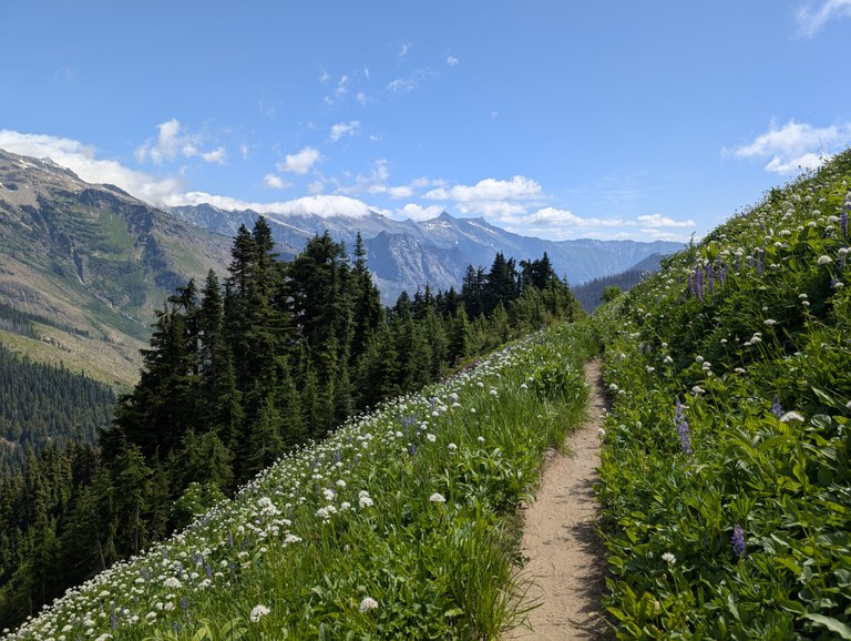
LOOWIT TRAIL
Location: Southwest Washington > Mount St. Helens
Length: 32 miles, roundtrip
Elevation gain: 6,000 feet

September views along the Loowit. Photo by Tiffany Chou.
Challenging and otherworldly, a full loop of the Loowit Trail is unlike almost any other hike you’ll do. Over 30 miles, you can cross vastly different (and difficult!) terrains — massive ravines cut through Mount St. Helens from its eruption 45 years ago, swaths of ash and volcanic rock, lush meadows of wildflowers, rocky boulder fields and more.
If you’re hoping for a shorter hike on the Loowit, the June Lake trail is the shortest approach to the Loowit, and makes for a great day hike (since the trailhead parking lot is day-use only). If you want to check out the blast zone, the Windy Trail and Loowit Falls are both mindblowingly beautiful; just remember that the trails are closed during weekdays in summer through 2027 for construction.
> Plan your hike around Mount St. Helens on the Loowit using WTA’s Hiking Guide
Luther Burbank Trail
Location: Puget Sound and Islands > Seattle-Tacoma area
Length: 3 miles, roundtrip
Elevation gain: 120 feet
A rainy winter day along the trail. Photo by Tiffany Chou
There’s much to see and enjoy at this waterfront park — miles of hiking trails, floating docks, small sand beaches, playgrounds and more. This urban park has it all. Fido and the little ones are sure to have fun on the playgrounds, sand beaches and off-leash dog areas (there’s even a dog shower!). Many large grassy areas make for perfect afternoon picnics on warmer fall days. And if pickleball is your thing, courts await you.
> Plan your hike to Luther Burbank using WTA’s Hiking Guide
Pacific Crest Trail Section K - Stehekin to Stevens Pass
Location: Central Cascades > Glacier Peak Wilderness
Length: 106 miles, one-way
Elevation gain: 19,300 feet
Wildflowers near White Pass in July. Photo by Tiffany Chou.
For those who want a challenge, to see some extraordinarily remote parts of Washington and meet some thru-hikers on the last leg of their long hike, this section of the PCT is arguably the toughest Washington section. It’s rugged, relentless, quiet and absolutely gorgeous.
Looking for something shorter? Starting from Stevens Pass, the hike to Lake Valhalla is a relatively mild alternative to the oft-taken route from the Smithbrook trailhead. And if you’re just looking to see one of the prettiest parts of this section of the PCT, check out the 30-mile White Pass - Pilot Ridge Loop; you’ll not only get one of the highlights of the section — especially around White Pass — but lovely old-growth forest, Blue Lake and incredible views along Pilot Ridge.
> Plan your hike along Section K using WTA’s Hiking Guide
Joe's Hikes
JOE GONZALEZ - Digital CONTENT COORDINATOR
 Joe grew up in the San Francisco Bay Area. He has been enchanted by the Pacific Northwest ever since thru-hiking across it along the Pacific Crest Trail in 2016. His passion for empowering hikers launched a career in guiding backcountry trips and developing adventure travel itineraries in iconic regions of the US. These opportunities have allowed him to thru-hike the Appalachian Trail, Continental Divide Trail, and more. He is excited about promoting equity and trail awareness in his current role as Digital Content Coordinator. When he’s not thru-hiking, you can find him foraging, paddling, or lost in a good story.
The Press Traverse
Location: Olympic Peninsula
Length: 44.0 miles, one-way
Elevation gain: 6,742 feet
.jpg")
Photo by Joe Gonzalez.
The Press Traverse is a historic route that slices north to south through the heart of Olympic National Park. It cuts through old growth rain forests, meanders along reclusive river valleys and passes historical cabins along the way. This point-to-point thru hike guarantees an intimate experience with Olympic National Park — fall mushrooms, tall trees and all!
To sample a portion of the route from the spacious Whiskey Bend trailhead on a trail through an old-growth forest with access to features like the Goblin's Gate, Rica Canyon, Krause Bottom and the historic Humes Ranch Cabin. 4.1 miles further will take you to Lillian Camp. Rest here and take advantage of the backcountry privies, or consider a short walk down the quiet Lillian River trail.
> Plan your hike along The Press Traverse using WTA’s Hiking Guide
Round Lake
Location:North Cascades > Mountain Loop Highway
Length: 11 miles roundtrip
Elevation gain: 4,300 feet

Photo on the way to Round Lake by Joe Gonzalez..
Round Lake is the perfect out-and-back option for hikers looking for a tucked-away weekend gem. Enjoy fiery berry patches and fungi galore, but expect to earn it: this rugged trail is steep, and in the late summer and early fall, hikers should be prepared for rime ice and freezing temperatures in the lake’s basin. Trekking poles (and maybe a mushroom guidebook) are preferred!
> Plan your hike to Round Lake using WTA’s Hiking Guide
The Wonderland Trail
Location: Mount Rainier
Length: 93 miles
Elevation gain: 22,000 feet

Photo by Joe Gonzalez.
The Wonderland Trail’s spot among Washington’s most iconic hikes is well-earned. And in the fall, it offers golden meadows of grass, brilliant deciduous foliage and amazing fungi biodiversity. Enter next year’s lottery, or day hike sections this fall to get a slice of autumn next to one of the PNW’s most famous volcanoes.
Research and learn more about 2026 permits or consider splitting your visit into three separate day hikes to enjoy fall in Mount Rainier:
> Plan your hike of The Wonderland Trail using WTA’s Hiking Guide
Holly's Hikes
HOLLY WEILER - SENIOR EASTERN WASHINGTON REGIONAL COORDINATOR
 Holly’s passion for trails has its roots in trail running, but over the years she has transitioned into a seasoned backpacker who loves her time in the backcountry. When she’s not running or backpacking, you can find her doing trail maintenance. An early introduction to trail work through Conservation Northwest turned into a bit of an obsession, and she's now the proud owner of four crosscut saws and two pulaskis. After several seasons of volunteer trail work and Hike-a-Thoning for WTA, she's excited to be doing outreach and leading trail work in the Spokane area — that is, when she’s not working on her MFA in Creative Writing at Eastern Washington University.
Mount Spokane State Park
Location: Eastern Washington > Spokane Area
Length: A system of 100+ miles
Elevation Gain: Various

Photo of Mount Spokane by Holly Weiler.
Mount Spokane State Park is the largest of all Washington State Parks, with an interconnected trail system of over 100 miles and containing eight named peaks with outstanding views of the surrounding landscape. That means the most difficult thing about hiking within Mount Spokane is narrowing down the options to decide which trails to choose!
Locals should probably just plan to hike here weekly throughout the fall in order to watch the long progression of fall colors: the huckleberry plants kick off the show following the first frost in September (choose trail 130 and 140, or the Nordic trail system), with the park’s aspen, Douglas maple, and cottonwood turning golden in early October (choose trail 110), and concludes with the western larch rounding out the show in mid-October (stand on any of those eight summits to take in the full impact, but if I had to choose one, it would be Mount Kit Carson).
> Plan your hike to Mount Spokane using WTA’s Hiking Guide
Fishtrap Recreation Area
Location: Eastern Washington
Length: 15+ miles of trails
Elevation gain: 126 feet
 Photo by Holly Weiler.
Hike here to experience a vibrant shrub-steppe ecosystem just off I-90, in a landscape shaped by the retreating Missoula Floods.
There are five main parking lots to access the trail system, which consists of over 15 miles of trails, some of which are singletrack and some of which are former farm roads. If visiting to glimpse a view of Fishtrap Lake and seek out the kolk (from the Dutch for vortex, a giant hole in the basalt carved by receding flood waters), the best access point is the Miller Ranch Trailhead for the North and South Fishtrap Loop. These trails can be completed individually for a hike of approximately 4.5 miles each, or can be combined to create a larger approximately 8 mile loop.
Those looking for a shorter hike option, especially those interested in birding opportunities, may prefer to access the trail system at Folsom Farm. A short out-and-back double-track trail above the wetlands is available from this location, which can optionally be extended to include the Hog Canyon Loop (approximately 6 miles). The Fishtrap Recreation Area is managed by the Bureau of Land Management, which allows both car camping at several sites near the trail system as well as backpacking. Since the majority of the fall color in this area consists of aspen groves, plan to visit in early October for maximum color. The leaves drop shortly after the first hard frost.
Safety tip: Fishtrap is a popular location for upland bird hunting, especially pheasant hunting. Many bird hunters have trained hunting dogs with them to retrieve their quarry. It is also open to other hunts that traditionally occur in the fall, so wearing hunter orange is advised, and non-hunting dogs should remain on leash.
> Plan your hike to Fishtrap using WTA’s Hiking Guide
Kettle Crest
Location: Eastern Washington > Kettle
Length: 44 miles, roundtrip
Elevation gain: 8,000 feet

Photo by trip reporter Bob and Barb.
Easy access and fabulous fall colors make the Kettle Crest an excellent choice for dayhiking, car camping, or backpacking. The main spine of the Kettle Crest National Recreation Trail is 43 miles long with three trailhead access points, and feeder trails offer additional access points to the Kettle Crest from both the east and west sides, opening up excellent route options of varying distances.
The best dayhiking options are available just off the pavement on Highway 20 at Sherman Pass, where the Sherman Peak Loop is a 6 mile option just south of the highway and the Columbia Mountain Loop is an 8 mile route just north of the highway (each accessed from the same parking lot). In late September into early October, Columbia Mountain might be best since it has a lovely aspen grove where the Loop Trail breaks off from the main Kettle Crest Trail. By mid-October the aspen will have started to lose their leaves, but the western larch will be putting on a fantastic show instead.
There will likely be some hunting presence during the fall hunting seasons, so it's advisable to wear blaze orange when visiting the Kettle Crest in the fall.
> Plan your hike to the Kettle Crest using WTA’s Hiking Guide
Allie’s Hikes
ALLIE TRIPP - STRATEGIC INITIATIVES SENIOR MANAGER
 Allie has worked at WTA since 2015, first on the fundraising team and more recently on the community engagement and impact team. Her perspective on hiking has changed in the last year as a new mom, where time in nature is even more needed and appreciated than ever before. You might see her on trails in the Teanaway or bird watching on the coast.
Ridgefield
Location: Central Cascades - Blewett Pass
Length: 6.5 miles, roundtrip
Elevation gain: 1,800 feet

Photo by trip reporter dirtbagmama.
While fall might make you think of foliage colors, for the bird-nerds out there, fall also brings color in the form of migrating birds. Ridgefield National Wildlife Refuge contains more than 5,000 acres of marshes, grasslands and wooded areas that is prime habitat for birds and other wildlife. WTA volunteer crews have also spent 11 days at Ridgefield this year improving the trails on this system, including installing 8 benches where you can pause and enjoy a warm beverage you’ve brought (or pop out your binoculars).
The accessible Kiwa Trail is a flat trail of crushed gravel or boardwalk, suitable for strollers and wheelchairs. This trail is only open from May 1-September 30; it closes in winter to provide quiet for nesting winter waterfowl.
> Plan your hike to Ridgefield National Wildlife Refuge using WTA’s Hiking Guide
SWAUK FOREST DISCOVERY TRAIL
Location: Central Casacdes - Blewett Pass
Length: 2.45 miles, roundtrip
Elevation gain: 660 feet
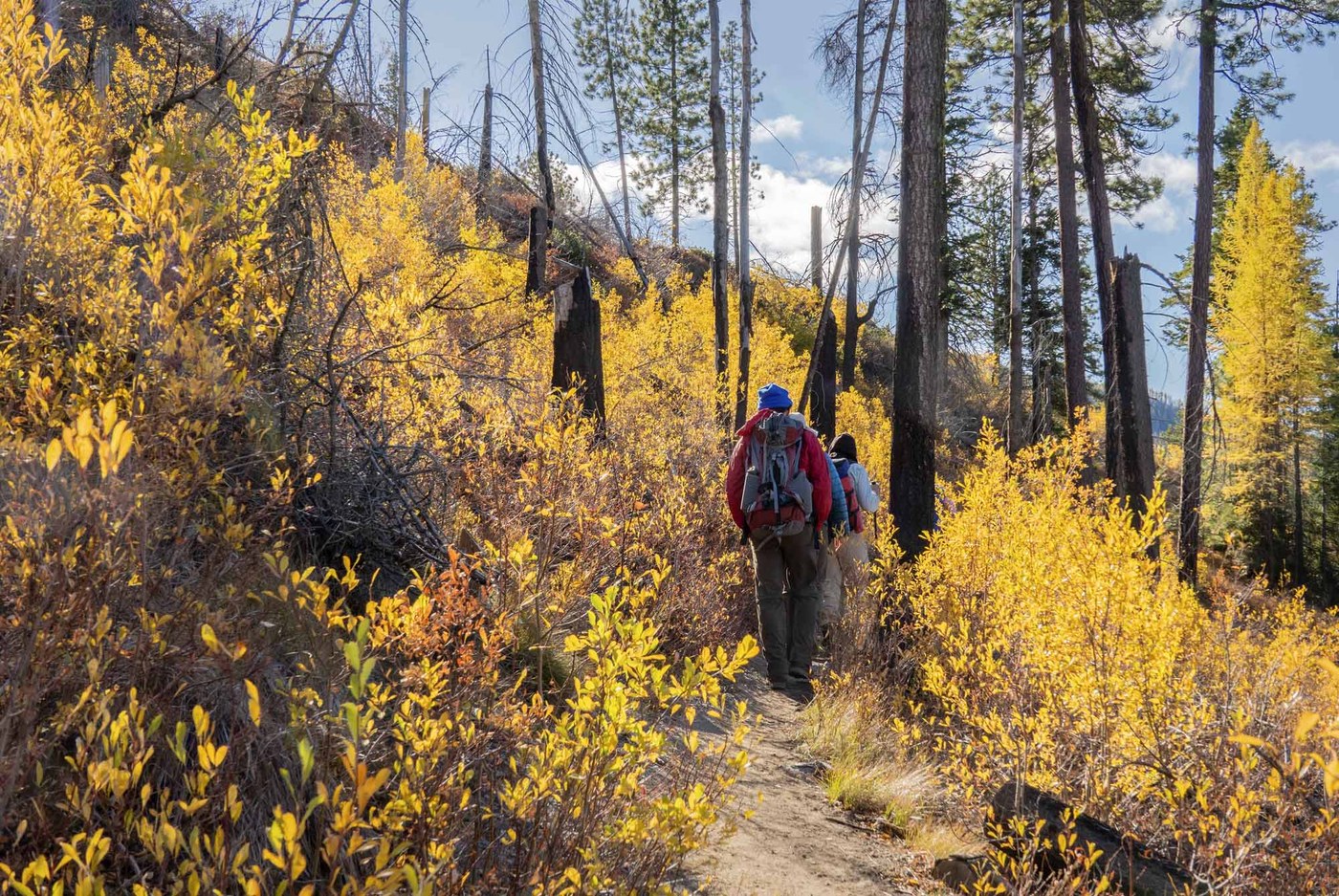
Photo by David Hagen.
For those of us who don’t have all day (or multiple days) to larch march, the Swauk Forest Discovery Trail is a relatively easy-to-access (off the highway) trail that offers a healthy dose of neon yellow larches in its 2.5 miles. It’s a great place to stop and stretch your legs while driving over Blewett Pass (to Leavenworth’s Oktoberfest, perhaps?) but also a straightforward trip from Ellensburg or Cle Elum.
Stopping to enjoy all the interpretive stops will definitely extend your time along this loop, there are also several log benches where you can pause and take in the color and smells of fall. This is a hike that can provide a real sense of achievement for younger hikers, though a close eye should be kept on them -- it’s also a great introductory hike to folks who have less miles under their belt.
> Plan your hike to Swauk Forest Discovery Trail using WTA’s Hiking Guide
Your Questions, Answered
There were so many great questions during Hike the State 2025, and we didn't have time to answer all of them. Here are a few we heard from several folks, along with our answers and links to WTA resources:
How do I know what pass or permit is needed for a particular trail?
Each hiking guide entry indicates what pass is needed to park at the trailhead, or if necessary, to camp in the area. You'll find it just above the photo for the hike, next to the heading "Parking Pass/Entry Fee". These passes and permits are determined by who manages the land you will be hiking on. To understand more about what is needed for different trails, WTA's Passes and Permits page explains the ins and outs of permits, including seasonal changes, costs, and why permits exist.
This fall, you will be able to buy a pass at some Forest Service trailheads using Scan and Pay. Learn more about this system here.
How can I enjoy a popular fall destination?
If you do want to see a popular larch destination, try to go during the week or super early to find safe and legal parking. Always go with a backup option or two nearby. It’s really important to park for the people. Emergency responders NEED to be able to get to a trailhead.
How can I find groups of people to go hiking with?
WTA has a resource page with links to a plethora of hiking groups around the state.
How can I access trail information when I’m out of service?
Once you have a WTA account and you are logged into it on the Trailblazer app on your phone, you’ll automatically have offline access to all the hikes you have saved in My Backpack.
I want to hike with my dog. any tips?
Our top tips: Learn where dogs are allowed to hike with you, keep your dog (and wildlife) safe by using a leash, and pick up and carry their waste out with you. (An old Tupperware or yogurt container is handy to prevent squish and smell.) In fall, dress them in bright colors, like a yellow, orange or pink reflective vest.
Raising a well-behaved hiking pup can be a challenging yet deeply rewarding process, and we want to help make it as easy (and fun!) as possible. From choosing dog-friendly hikes to keeping your four-legged buddy safe, we have more tips to help prepare you and your pup for a great time on trail.
What should I know about encountering wildlife on my adventures?
It is very common to have concerns about running into animals, large and small, while out hiking. Please keep in mind that a lot of behaviors that help keep humans safe are also important because they keep wildlife safe and protected, like staying on trail, not approaching or feeding wildlife (no matter how cute or friendly they are) and properly storing food, including packing out the waste from all the food you pack in, including pistachio shells, banana or orange peels, sunflower seeds, etc.
For more specific tips on hiking with various wildlife, check out the following guides to build up your knowledge: